Hervartov
| Hervartov | ||
|---|---|---|
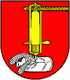
| coat of arms | map | |

|
|
|
| Basic data | ||
| State : | Slovakia | |
| Kraj : | Prešovský kraj | |
| Okres : | Bardejov | |
| Region : | Šariš | |
| Area : | 9.872 km² | |
| Residents : | 517 (Dec. 31, 2019) | |
| Population density : | 52 inhabitants per km² | |
| Height : | 450 m nm | |
| Postal code : | 086 22 | |
| Telephone code : | 0 54 | |
| Geographic location : | 49 ° 15 ' N , 21 ° 12' E | |
| License plate : | BJ | |
| Kód obce : | 519243 | |
| structure | ||
| Community type : | local community | |
| Administration (as of November 2018) | ||
| Mayor : | Miroslav Mackanič | |
| Address: | Obecný úrad Hervartov 84 08622 Kľušov |
|
| Website: | www.hervartov.sk | |
| Statistics information on statistics.sk | ||
Hervartov (German Herbertsdorf , Hungarian Hervartó ) is a municipality in northeastern Slovakia 9 km southwest of Bardejov .
The remote place, which lies in the eastern foothills of the Čergov , was first mentioned in 1406 as Eberhardtuagasa . It was founded by German colonists, but the German residents were assimilated by the Slovaks over the centuries. At first the place belonged to the rule of Hertník , then later to the city of Bardejov.
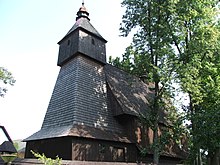
The Roman Catholic wooden church from 1593 to 1596, which is dedicated to St. Francis of Assisi , is worth seeing . The church is possibly the oldest surviving wooden church in Slovakia. In 2008 the building was inscribed on the UNESCO World Heritage List .
Web links
Commons : Hervartov - collection of images, videos and audio files

