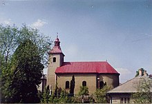
Fričkovce
| Fričkovce | ||
|---|---|---|
| coat of arms | map | |

|
|
|
| Basic data | ||
| State : | Slovakia | |
| Kraj : | Prešovský kraj | |
| Okres : | Bardejov | |
| Region : | Šariš | |
| Area : | 9.351 km² | |
| Residents : | 735 (Dec. 31, 2019) | |
| Population density : | 79 inhabitants per km² | |
| Height : | 465 m nm | |
| Postal code : | 086 42 ( Hertník Post Office ) | |
| Telephone code : | 0 54 | |
| Geographic location : | 49 ° 11 ' N , 21 ° 15' E | |
| License plate : | BJ | |
| Kód obce : | 519162 | |
| structure | ||
| Community type : | local community | |
| Administration (as of November 2018) | ||
| Mayor : | Matej Straka | |
| Address: | Obecný úrad Fričkovce č. 103 086 42 Hertník |
|
| Website: | www.frickovce.sk | |
| Statistics information on statistics.sk | ||
Fričkovce (German Fritschhau , Hungarian Alsófricske - until 1907 Fricske is a municipality in) east of Slovakia with 735 inhabitants (December 31, 2019). It belongs to the Okres Bardejov , a Prešovský kraj district , and is part of the traditional Šariš landscape .
geography
The municipality is mainly located in the so-called Raslavice furrow (in Slovak Raslavická brázda ) in the western part of the Ondavská vrchovina mountain range and is traversed by the Fričkovský creek . The western part of the municipality extends to the main ridge of the Čergov Mountains , so the municipality is exactly on the border between the Western and Eastern Carpathians . The center of the village is at an altitude of 465 m nm and is 14 kilometers from Bardejov and 30 kilometers from Prešov .
Neighboring municipalities are Hertník in the north, Bartošovce in the east, Osikov in the southeast and south and Terňa (district Hradisko) in the west.
history
The place was first mentioned in writing in 1427 in a Porta directory of the Sáros County as Frychchaw , in the same year there were 24 Porta in Fričkovce, which at that time corresponded to a medium-sized village. However, the village was founded in the 14th century by a mayor on a property of the Perényi family . In the late 15th and first half of the 16th century the village was owned by the Mariássy family , and in the second half of the 16th century by the Bornemissza and Darholc family . In 1600 there were 20 subject houses and one mayor's house in the village, in 1828 there were 65 houses and 497 inhabitants, whose main sources of income were forestry, agriculture and clapboard. The first school in town was founded in 1883, before that the students had to attend a school in neighboring Osikov. Because of the local famine, many residents emigrated in the late 19th and early 20th centuries.
The place in Sáros County belonged to the Kingdom of Hungary until 1918 and then came to Czechoslovakia or now Slovakia. After the Second World War, the infrastructure was gradually expanded: in 1950 the entire village was electrified, between 1988 and 1991 all households were connected to a natural gas supply, and sewage pipes were built from 1992–1994.
population
According to the 2011 census, Fričkovce had 686 inhabitants, 663 of whom were Slovaks , two Russians and one Ukrainian . 20 residents gave no information on ethnicity.
651 residents confessed to the Roman Catholic Church and one resident to the Evangelical Church AB. One resident was non-denominational and the denomination of 20 residents was not determined.
Buildings
- Roman Catholic Martinskirche in the classical style from the years 1821-22
- Roman Catholic Church of Mary of the Rosary from 1997
Individual evidence
- ↑ Results of the 2011 census (Slovak) ( Memento of the original from March 5, 2016 in the Internet Archive ) Info: The archive link was inserted automatically and has not yet been checked. Please check the original and archive link according to the instructions and then remove this notice.
Web links
- Entry on e-obce.sk (Slovak)


