
Tatranská Javorina
| Tatranská Javorina | |||
|---|---|---|---|
| coat of arms | map | ||

|
|
||
| Basic data | |||
| State : | Slovakia | ||
| Kraj : | Prešovský kraj | ||
| Okres : | Poprad | ||
| Region : | Tatry | ||
| Area : | 94.021 km² | ||
| Residents : | 198 (Dec. 31, 2019) | ||
| Population density : | 2 inhabitants per km² | ||
| Height : | 1000 m nm | ||
| Postal code : | 059 56 | ||
| Telephone code : | 0 52 | ||
| Geographic location : | 49 ° 16 ′ N , 20 ° 8 ′ E | ||
| License plate : | PP | ||
| Kód obce : | 580368 | ||
| structure | |||
| Community type : | local community | ||
| Structure of the municipality: | 2 parts of the community | ||
| Administration (as of November 2018) | |||
| Mayor : | Alena Pitoňáková | ||
| Address: | Obecný úrad Tatranská Javorina 33 05956 Tatranská Javorina |
||
| Website: | www.tjavorina.eu | ||
| Statistics information on statistics.sk | |||

Tatranská Javorina ( German Uhrngarten or Urgarten , Polish Jaworzyna Tatrzańska , Hungarian Javorina ) is a municipality in northeastern Slovakia . It is located at the foot of the High Tatras , about 25 km from Zakopane in Poland and 45 km from Poprad .
history
The community started in the 18th century. In 1759 an ironworks with hammer and blast furnace was built in the area of today's town, and in 1837 a rolling mill was built. This plant was closed in the middle of the 19th century and a cardboard factory and wood pulp production were opened in 1875. As a result of the industrial settlement, a seasonal settlement was created around the factory, which was officially included in the Jurgov / Jurgów municipality and was independent from 1863.
In 1879 the area was bought by the Prussian nobleman Christian Kraft, Prince of Hohenlohe-Öhringen . He expanded the small town and tried to set up a wild life.
In 1918 the place became a border town to Poland and was a point of contention between the two states in the Czechoslovak-Polish border conflicts . From September 1938 to November 1939, the place was then occupied by Poles and was named Jaworzyna Spiska . From 1947 to the end of 1992 the municipality was part of Ždiar .
Surname
The name of the place comes from the former maple forests (Slovak javor ) in the area, after which some geographical objects were named (river Javorinka , valley Javorová dolina and peak Javorový štít (2417.6 m above sea level)). The German name comes from the dialect pronunciation of "Ahorngarten", other forms mentioned are also Urengarten and Urngarten .
local community
The settlement Podspády (German Fluder ) also belongs to the municipality .
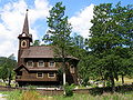
Wooden church in Javorina

Tatranská Javorina-Łysa Polana border crossing . The Biela voda (pol. Białka) river flows on the right.

Controversial border area between Poland and Slovakia around Javorina


See also
- Czechoslovak-Polish border conflicts (Map area No. 6)