Mainz-Upper Town
|
Upper town district of Mainz |
||||||||||||||||||||||
|---|---|---|---|---|---|---|---|---|---|---|---|---|---|---|---|---|---|---|---|---|---|---|
| Coordinates | 49 ° 59 '23 " N , 8 ° 15' 54" E | |||||||||||||||||||||
| height | 87 m above sea level NN | |||||||||||||||||||||
| surface | 5.868 km² | |||||||||||||||||||||
| Residents | 22,086 (Dec. 31, 2019) | |||||||||||||||||||||
| Population density | 3764 inhabitants / km² | |||||||||||||||||||||
| Proportion of foreigners | 20.1% (Dec. 31, 2019) | |||||||||||||||||||||
| Post Code | 55131 | |||||||||||||||||||||
| prefix | 06131 | |||||||||||||||||||||
Administration address |
Gleiwitzer Strasse 2 55131 Mainz |
|||||||||||||||||||||
| Website | www.mainz.de | |||||||||||||||||||||
| politics | ||||||||||||||||||||||
| Mayor | Daniel Köbler ( Greens ) | |||||||||||||||||||||
| Allocation of seats (local advisory board) | ||||||||||||||||||||||
|
||||||||||||||||||||||
| Transport links | ||||||||||||||||||||||
| tram | MVG Mainz lines 50, 52, 53 | |||||||||||||||||||||
| bus | MVG Mainz line 9, 62, 64, 65, 66, 67, 69, 70, 71, 76, 78, 90, 93, ORN line 652, 660, MVG Mainz - ORN community line 75 | |||||||||||||||||||||
Oberstadt is a district of the Rhineland-Palatinate state capital Mainz .
It essentially comprises the parts of Mainz that were built after the first north-west expansion of the city in the 1870s in the south and south-west of the (then) city at the beginning of the 20th century. The new residential area created in this way has a completely different character than the Neustadt : In Mainz-Oberstadt loosened, green-colored settlements dominate. During the Second World War , this area suffered significantly less damage than the old and new towns, so that buildings from the first half of the 20th century can be found everywhere. The local district as an administrative unit was only created in 1989 when the former inner city district was divided into Oberstadt, Neustadt, Altstadt and Hartenberg-Münchfeld . With around 22,000 inhabitants, the Upper Town is the third largest district in Mainz after Neustadt and Gonsenheim .
Location and scope
A large part of the upper town arose in the area of fortifications that were razed at the beginning of the 20th century, from which the Mainz green belt was created; the planning concept for the southern expansion of Mainz was presented in 1908 by Friedrich Pützer .
Neighboring districts
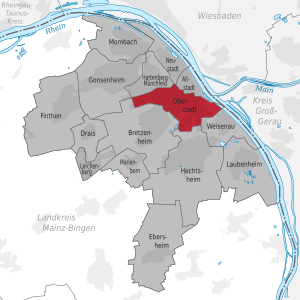
The following districts of Mainz border the Upper Town in a clockwise direction:
in the north Mainz-Neustadt and Mainz-Altstadt , in the south-east Mainz-Weisenau , in the south Mainz-Hechtsheim , in the south-west Mainz-Bretzenheim and in the north-west Mainz-Hartenberg-Münchfeld .
Borderline
The northernmost point of the upper town is on Alicenplatz, where the new town from the northwest, the old town from the east and the upper town from the south meet. Alicenstraße goes uphill to the south-southeast in the direction of Kästrich ; to the west you can see the entrance to the two Mainz railway tunnels . To the east is the old town. The border leads on the slope between Kupferbergterrasse and Terrassenstrasse, and in the extension between Mathildenstrasse (both sides of Oberstadt) and Breidenbacherstrasse (both sides of the old town) around Kästrich to Gautor, where it bends in an easterly direction and leads over Eisgrubweg towards the citadel and Roman theater . St. Stephen's Church is located north of the Eisgrubweg in the old town . From the Roman Theater, the border follows the Mainz-Worms railway line southeast to the Mainz-Weisenau border , the easternmost point of the upper town.
From the eastern edge of the Volkspark, the border between Oberstadt and Weisenau runs west-southwest to Hechtsheimer Strasse, past the Theresianum and the former IBM site. From there, the upper town borders on Mainz-Hechtsheim to the south, the border runs in a westerly direction along the Academy of Sciences and Literature and the Kurmainz barracks. From the Kurmainz barracks, the border leads north-east along the Dampfbahnweg (a dirt road, the name of which is reminiscent of the local Mainz steam train that ran here until the 1920s ), to the left of which the Wildgraben, which already belongs to Bretzenheim, flows. Passing the high-rise buildings of the Berlin settlement, the border turns to the northwest and runs along the Schaftriebweg (right you look up to the Rodelberg). To the southwest of the Paris Gate , the border crosses Pariser Strasse . On the other side, the border (further on the Schaftriebweg) runs again in (but only on the upper town side) built-up area along the south-western edge of the Silesian Quarter. It crosses the Wildgraben to the south and follows it a little to the west. The Wildgraben kinks to the north into the sewer system, while the border towards the south to the street “Am Wildgraben”. In the area of the former Zahlbach, the border follows in a west-northwest direction, south of the main cemetery and the university grounds (sports institute and botanical garden ) to Koblenzer Straße. The former Roman aqueduct is located in this area. The Koblenzer Straße follows the border to the north as far as Saarstraße, which, leading to the east, separates the upper town from Hartenberg-Münchfeld . Down Saarstrasse, the border runs along the main cemetery to the Employment Agency, and via Binger Strasse and Alicenbrücke to the northeast back to Alicenplatz.
District of the upper town
The west of the upper town is formed by the university .
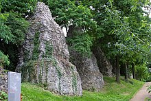
The strip east of it forms the left slope of the Zaybach valley with the main cemetery in the north, the Jewish cemetery on its southern edge, and south of it the area around the Römersteine (with the buildings of the former Hildegardis-), formerly known as “Attach” (from “Aqueduct”) Hospital in the middle). This part of the Zaybach valley with its steep slopes forms the northern part of the former suburb of Zahlbach (incorporated in 1804).
The right slope of the Zaybach valley rises to the former Roman legion camp. To the north of this is the well-to-do residential area on Linsenberg, which was created in the course of the fortress expansion (where the first traces of settlement from the Paleolithic were found); to the south is the university clinic ; to the south of this, in turn, is the Silesian Quarter, which was built in 1933/34 as a "Frontkämpfersiedlung" and expanded after the Second World War to provide housing for the professors and employees of the newly built university.
From the Linsenberg to the citadel, the Römerwall / Drususwall runs through the upper town from west to east. To the north is the Kästrich , which is closed in the south by the Powder Tower and Gautor . Here is the tip of the conspicuously fan-like spreading settlement on Fichteplatz towards the southwest . This was created as a large housing project after the First World War with 1,000 residential units. Plans by Friedrich Pützer were already available from before the First World War; City planning officer Fritz Luft was responsible for the planning . The individual buildings were built by various architects, mostly in the spirit of the New Objectivity . To the south of it you can find the Gutenberg Gymnasium and the Mainz Turnverein from 1817 (the second oldest sports club in Germany), and finally the Rodelberg, an artificial (now populated) mountain that was raised from the excavation of the slitting of the railway tunnel between 1932 and 1934.
The valley created by the slitting of the railway tunnel with the railway connection from the main train station to the Mainz Römisches Theater train station is located east of the Gautor on the northern edge of the district. To the south of it, on the other side of the Drusus Wall, lies the settlement at Fort Elisabeth . The settlement was built between 1954 and 1958 and is a characteristic (and considered convincing) example of the then modern urban architecture. In a relaxed arrangement there are two star houses, two disc houses and an arcade house, sophisticated house types of the time, as well as the trapezoidal former administration building of Westbauträger GmbH. Against the background of the rather conceptless rebuilding of Mainz after its destruction in the Second World War, this settlement is still highlighted as a successful architectural project of the time. An original draft had taken up the reconstruction planning by Marcel Lods in a modified form. However, it was never realized, and the resulting settlement is far from this approach.
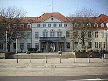
To the east of the settlement is the Vincenz and Elisabeth Hospital of the Catholic Clinic in Mainz , to the south then the Military District Command II (formerly IV) of the Bundeswehr in the Generalfeldzeugmeister barracks and the Rodelberg. To the east of the barracks is the Friedrich Ebert-Siedlung , which was founded between 1928 and 1930 on the initiative of the later Lord Mayor Franz Stein , among others . In the south on the Rodelberg lies the Berlin settlement , which was built in the early 1960s as part of Ernst May's urban planning and was given its name when the Berlin Wall was built at the time .
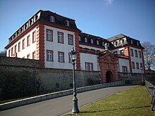
Again in the north, the citadel offers a good view of the old town of Mainz . To the south of it continues the green belt (which also includes the area on the Linsenberg and the Römer / Drususwall), which is closed off by an allotment garden on the southern edge of the district. To the east of the citadel is the city park on the site of the former Favorite , which, like the settlement area to the south of it (with the Ketteler settlement built by the Catholic Ketteler-Bauverein from 1923 to 1933 ) and the Volkspark to the southeast of Favorite, are counted as part of the green belt becomes.
Buildings, squares and other sights of the Upper Town
- Roman theater (excavations)
- Roman city gate
- Moguntia
- Reading Foundation
- Sektkellerei Kupferberg
- Roman stones
- Villa Musica on the bastion
- Drususstein
- city Park
- At the monastery garden
- Main cellar door of the former Mainzer Aktien beer brewery
- citadel
- Main cemetery Mainz
- Bust of Peter Cornelius by Hugo Lederer (1930)
- University Botanical Garden
- Settlement on Fichteplatz
- Settlement at the Charterhouse
- The Görzsiedlung of Bau- und Sparverein Mainz (a residential area in the Zahlbachtal below the university clinic, opposite the Roman stones). The Mainz merchant Adolf Görz (from 1857 to 1900) donated 300,000 marks to the city for charitable purposes, which were used to build this settlement with green inner courtyards (from 1903 to 1937). The estate is considered a well-preserved example of cooperative housing in Mainz. It consists of eleven closely spaced, symmetrically arranged three or four-story apartment buildings in a restrained home style .
- Luther Church , built in 1949 as the first church in Mainz after the Second World War as a so-called emergency church by Otto Bartning .
- Alice Clinic
politics
The Mainz-Oberstadt local council consists of 13 members. The Greens have been the strongest parliamentary group with four seats since the local elections in 2019 . A total of seven parties are represented in the current local advisory board (for details see info box).
The mayors of the district, which has been independent since 1989, have been:
- Wilfried Jung (SPD, 1989-2009)
- Ursula Beyer (SPD, 2009-2019)
- Daniel Köbler (Greens, since 2019)
traffic
A part of the former federal highway 40 runs through the upper town , over which there is a transition to the A 63 at the Mainz-Süd interchange . Another important traffic artery is the Saarstrasse, which is partly in the area of the Mainzer Oberstadt and leads from Finthen over the university area towards the main station.
The district is connected to the local public transport system of the city of Mainz by several MVG bus and tram lines. The city center can be reached in just under 10 minutes. Two ORN bus routes provide connections to the municipalities of the Mainz-Bingen and Alzey-Worms districts .
literature
- Claus Wolf: The districts of Mainz. Emons Verlag, Cologne 2004, ISBN 3-89705-361-6
- Franz Dumont (ed.), Ferdinand Scherf, Friedrich Schütz: Mainz - The history of the city. Zabern, Mainz 1999 (2nd edition), ISBN 3-8053-2000-0
- Wilhelm Huber: The Mainz Lexicon. Hermann Schmidt, Mainz 2002, ISBN 3-87439-600-2
Web links
- Information from the City of Mainz on the Oberstadt district
- Settlement at Fort Elisabeth. In: arch INFORM .
- Residents in Mainz by district on December 31, 2019 - mainz.de (PDF)
Individual evidence
- ↑ Informational directory of cultural monuments - district-free city of Mainz (PDF; 1.2 MB) Ed .: Rhineland-Palatinate General Directorate for Cultural Heritage
- ↑ Article on the election of Ursula Beyer
- ↑ Preliminary final result of the election of the mayor in Mainz-Oberstadt


