Strait of Gibraltar
| Strait of Gibraltar | ||
|---|---|---|
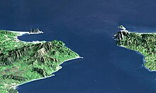
| Satellite image (left: Spain, right: Morocco) | ||
| Connects waters | Mediterranean Sea | |
| with water | Atlantic Ocean | |
| Separates land mass | Morocco (NW- Africa ) | |
| of land mass | Iberian Peninsula (SW Europe ) | |
| Data | ||
| Geographical location | 35 ° 58 ′ N , 5 ° 29 ′ W | |
|
|
||
| length | 60 km | |
| Smallest width | 14 km | |
| Coastal towns | Tarifa , Gibraltar , Ceuta | |
| Islands | Isla de Las Palomas , Isla del Perejil , Isla de Santa Catalina | |
The Strait of Gibraltar (also known as the Strait of Gibraltar ; in ancient times fretum Gaditanum or fretum Herculeum ) is a strait that connects the Mediterranean Sea to the Atlantic Ocean . It is bordered in the north by Spain with the southernmost city of mainland Europe, Tarifa , and the British crown colony Gibraltar , in the south by Morocco and the Spanish exclave Ceuta . Both Gibraltar and Ceuta, known in antiquity as the " Pillars of Heracles ", and Tarifa are important port cities . The Strait of Gibraltar is 14 to 44 km wide and about 60 km long. It reaches a depth of 300 m to 900 m below sea level .
The Strait of Gibraltar is one of the busiest waterways in the world, with around 300 merchant ships passing through it every day. Due to the constant east-setting current on the surface, caused by the approximately 1.4 m lower level of the Mediterranean compared to the Atlantic in connection with the often prevailing westerly winds, which are intensified in the street by jet action , it has long been an obstacle difficult for ships to overcome . In the depths there is a countercurrent with which the more salty Mediterranean water flows into the Atlantic. In ancient times it was only through this countercurrent, which was made usable with a sea anchor as a drive, that ships could sail from the Mediterranean into the Atlantic.
To protect marine mammals in the strait, the Spanish government has set a speed limit of 13 knots (24 km / h) for ships.
history
The entire region is an area of strong tectonic activity.
About six million years ago, the strait closed, turning the Mediterranean into a vast salt lake that eventually dried up. This period and the processes associated with it are known as the Messinian salinity crisis .
About 5.33 million years ago, at the turn of the Miocene to the Pliocene , the latest findings indicate that the land bridge between Europe and Africa was initially slightly lowered , so that only small amounts of water spilled from the Atlantic into the dried-up Mediterranean basin for several millennia. Gradually, the water dug deeper and deeper into the land bridge until finally about 100 million cubic meters per second flowed in through a 200 kilometer long and up to 11 kilometer wide canal, with a speed of 144 kilometers per hour the flow channel by 40 centimeters per Day deepened (Zanclean flood). A total of 500 cubic kilometers of rock was washed away. As a result, at the height of this process, the water level in the Mediterranean basin rose daily by more than 10 meters until the Mediterranean was refilled after a maximum of two years. Since then, this strait has been the only natural connection between the Atlantic and the Mediterranean and Black Seas.
Location, settlement
![]() Map with all coordinates: OSM | WikiMap
Map with all coordinates: OSM | WikiMap

According to the IHO , the Strait of Gibraltar is to the west by a line from Cape Trafalgar ( 36 ° 10 ′ 57 ″ N , 6 ° 1 ′ 58 ″ W ) to Cape Spartel ( 35 ° 48 ′ 2 ″ N , 5 ° 54 ′ 22 ″ W ) , and to the east by a line from Europa Point ( 36 ° 6 ′ 34.2 ″ N , 5 ° 20 ′ 46.5 ″ W ) , the southernmost point of Gibraltar, to Punta Almina ( 35 ° 54 ′ 0 , 9 ″ N , 5 ° 16 ′ 41.2 ″ W ) , the easternmost point of the city of Ceuta.
On the northern coastline in Europe (Trafalgar – Gibraltar) from west to east lie Cádiz , San Fernando , Chiclana de la Frontera , Conil de la Frontera , El Palmar de Vejer , Cape Trafalgar , Los Caños de Meca , Barbate (also the one of the same name Estuary), Zahara de los Atunes , Punta Paloma , Tarifa , Algeciras with its wide bay, Los Barrios , San Roque , La Línea de la Concepción and Gibraltar.
The only islands in the Strait of Gibraltar are three islands very close to the coast, namely the Isla de Las Palomas off the city of Tarifa , the Isla del Perejil west of Ceuta and the small Isla de Santa Catalina belonging to Ceuta . About 150 km east of the strait is the uninhabited Spanish Isla de Alborán : The sea area in the western Mediterranean around and west of the island to the Strait of Gibraltar is named after its Alborán Sea .
The southern coast of the road is made up of Cape Spartel (رأس سبارتيل, the most north-western point of Africa), Tangier , Punta Malabata , Ksar-es Sehir , Benzú and Ceuta ( Tetuan further inland).
The threshold to the Mediterranean
At the surface of the water, over 1 million cubic meters of water flow from the Atlantic Ocean into the Mediterranean Sea every second. In the opposite direction, a little less water flows from the Mediterranean towards the Atlantic. This salty, heavy deep water flows close to the sea floor over the Gibraltar sill, which is around 300 meters deep at its lowest point, into the Atlantic. There it sinks to a depth of 600 to 1500 meters. It flows northwards off the coast of the Iberian Peninsula.
is located in the east and Tandscha / Tangier to the west .
Illegal immigration
Since Spain's accession to the European Union , the region around Tarifa has been increasingly targeted by Africans, especially from the Maghreb , who are trying to illegally enter Europe because of its proximity to the Moroccan coast . The strong current, the winds and the often violent waves make the few kilometers of crossing on the mostly overloaded and unsuitable boats a dangerous and often fatal endeavor. Hundreds of drowned people are found on Spanish beaches every year. In the years from 1997 to 2001, according to a census by the Moroccan Association of Friends and Families of Victims of Illegal Immigration ( l'Association des amis et familles des victimes de l'immigration clandestine , AFVIC) on the Moroccan and Spanish coastal strips of the Gibraltar found a total of 3,286 dead. How many are drifted off to sea and never found is unknown. It is estimated that the number is about three times as high as that of those washed up on the beaches - almost 2,000 more deaths per year.
Projects
For several years, plans have been drawn up to build a bridge to connect Africa and Europe. This would be one of the longest bridges in the world. In addition to the length, the tectonic conditions and the protection of the pillars from ship collisions would place particular demands on the designers.
At the end of 2003, Spain and Morocco agreed on a budget of 27 million euros for the preparation of feasibility studies for a two-tube railway tunnel with a maintenance tunnel . On January 31, 2007, the European Commission adopted “Guidelines for Transport in Europe and the Neighboring Regions”. Among the five transnational axes as “motorways of the sea” was the “southwest axis”: “Connection of the south-western region of the EU with Switzerland and Morocco, with a connection to the Trans-Maghreb corridor through Morocco, Algeria and Tunisia as well as its extension to Egypt”. According to a report by orf.at, Morocco has submitted its plans for a Gibraltar tunnel. The 2006 design competition for the tunnel was won by Giovanni Lombardi .
A more unrealistic project is the construction of a dam across the Strait of Gibraltar. The plan goes back to the German architect Herman Sörgel , who planned and pursued this project, which became known under the name Atlantropa , from 1928. The plan was to build a gigantic dam in the Strait of Gibraltar , which would have caused the sea level in the Mediterranean to drop by around 100 to 200 meters. The primary goal of this intergenerational project should be to gain new territory and energy for Europe and the African Mediterranean countries in abundance. A similar project for a partial dam was called in 1997 to mitigate climate change by diverting currents in the Atlantic.
Trivia
The Strait of Gibraltar is a stretch of the Ocean's Seven .
Movie
- Sven Jaax: A ferry to Africa. (Documentation, Germany, 2010, 43 min.)
- Daniele Grieco: The Last Giants - When the Sea dies (documentary, Germany, 2009, 92 min.)
Web links
Individual evidence
- ^ D. Garcia-Castellanos et al .: Catastrophic flood of the Mediterranean after the Messinian salinity crisis. In: Nature Vol. 462, December 10, 2009, pp. 778-781, doi : 10.1038 / nature08555 .
- ^ International Hydrographic Organization: Limits of Oceans and Seas. (= Special Publication. No. 28). 3rd edition, Inprimerie Monégasque, Monte-Carlo 1953 ( full text as PDF file ).
- ^ RG Johnson: Climate control required a dam at the Strait of Gibraltar. In: Eos, Transactions American Geophysical Union. July 8, 1997, Vol. 78. No. 27, pp. 277-281, doi : 10.1029 / 97EO00180 .


