Montgomery County, Alabama
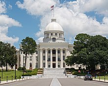
 Montgomery County Courthouse |
|
| administration | |
|---|---|
| US state : | Alabama |
| Administrative headquarters : | Montgomery |
| Address of the administrative headquarters: |
County Courthouse P.O. Box 1667 Montgomery, AL 36102-1667 |
| Foundation : | December 6, 1816 |
| Made up from: | Mississippi Territory |
| Area code : | 001 334 |
| Demographics | |
| Residents : | 229,363 (2010) |
| Population density : | 112.2 inhabitants / km 2 |
| geography | |
| Total area : | 2071 km² |
| Water surface : | 27 km² |
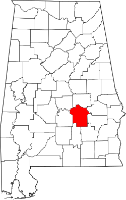
| map | |
| Website : www.mc-ala.org | |
The Montgomery County is a county in the US state of Alabama of the United States . The county seat is Montgomery .
geography
The county is located in southeastern Alabama and has an area of 2071 square kilometers, of which 26 square kilometers are water. It is bordered clockwise by the following counties: Elmore County , Macon County , Bullock County , Pike County , Crenshaw County , Lowndes County, and Autauga County .
history
Montgomery County was formed from the Mississippi Territory on December 6, 1816. It was named after Major Lemuel P. Montgomery of Virginia , who was fatally wounded in the Battle of Horseshoe Bend .

64 buildings and sites in the county are on the National Register of Historic Places (NRHP) (as of April 5, 2020), four of them have the status of a National Historic Landmark : the Alabama State Capitol , Dexter Avenue Baptist Church , Montgomery Union Station and Trainshed and the United States Post Office and Courthouse-Montgomery .
Demographic data
| growth of population | |||
|---|---|---|---|
| Census | Residents | ± in% | |
| 1820 | 6604 | - | |
| 1830 | 12,695 | 92.2% | |
| 1840 | 24,574 | 93.6% | |
| 1850 | 29,711 | 20.9% | |
| 1860 | 35,904 | 20.8% | |
| 1870 | 43,704 | 21.7% | |
| 1880 | 52,356 | 19.8% | |
| 1890 | 56.172 | 7.3% | |
| 1900 | 72,047 | 28.3% | |
| 1910 | 82,178 | 14.1% | |
| 1920 | 80,853 | -1.6% | |
| 1930 | 98,671 | 22% | |
| 1940 | 114,420 | 16% | |
| 1950 | 138.965 | 21.5% | |
| 1960 | 169.210 | 21.8% | |
| 1970 | 167,790 | -0.8% | |
| 1980 | 197.038 | 17.4% | |
| 1990 | 209.085 | 6.1% | |
| 2000 | 223.510 | 6.9% | |
| 2010 | 229.363 | 2.6% | |
| Before 1900
1900–1990 2000 2010 |
|||

As of the 2000 census , Montgomery County's population was 223,510. Of these, 12,043 people lived in collective accommodation, the other residents lived in 86,068 households and 56,804 families. The population density was 109 inhabitants per square kilometer. The racial the population was composed of 48.85 percent white, 48.58 percent African American, 0.25 percent Native American, 0.99 percent Asian, 0.03 percent from the Pacific island area and 0.35 percent from other ethnic groups Groups; 0.94 percent were descended from two or more races. 1.19 percent of the population were Hispanic or Latino of any race.
Of the 86,068 households, 32.2 percent had children and adolescents under the age of 18 living with them. There were married couples living together in 43.8 percent, 18.6 percent were single mothers, 34.0 percent were non-families, 29.5 percent of all households were single households and 9.4 percent had people aged 65 and over or above. The average household size was 2.46 and the average family size was 3.06.
25.8 percent of the population were under 18 years old, 11.7 percent between 18 and 24, 29.8 percent between 25 and 44, 20.9 percent between 45 and 64 and 11.8 percent were 65 years or older. The median age was 34 years. For every 100 females there were 90.8 males and for women aged 18 and over there were 86.7 males.
The median income for a household in the 35,962 USD , and the median income for a family 44,669 USD. Males had a median income of $ 32,018 versus $ 24,921 for females. The per capita income was $ 19,358. 13.5 percent of families and 17.3 percent of the population lived below the poverty line.
Worth seeing
The city of Montgomery is home to the Jasmine Hill Gardens and Outdoor Museum , an 80,930 square meter botanical garden and museum .
Places in Montgomery County
- Ada
- Barachias
- Bethlehem
- Boylston
- Brassell
- Brassell Bottom
- Canaan
- Cantelous
- Canty
- Capitol Heights
- Carter's Hill
- Catoma
- Cecil
- Chisholm
- Cooks
- Curries
- Davenport
- Davis Crossroads
- Dublin
- Flatwood
- Fleta
- Friendship
- Gibson
- Grady
- Hobbie Farm
- Hope Hull
- Hunter
- Kilby
- Lapine
- Le Grand
- London
- Lynndale
- Macedonia
- Mommy
- McDade
- Meadville
- Merry
- Mitylene
- Montgomery (City)
- Mount Carmel
- Mount Meigs
- Mount Meigs Station
- Naftel
- Perry's Mill
- Pike Road (Town)
- Pine level
- Pinedale
- Pintlala
- Ramer
- Red level
- Robinson Crossroads
- Roxana
- Sellers
- Shepherd Hill
- Snowdoun
- Southmont
- Sprague
- Steiner
- Stills Crossroads
- Strata
- Taylor
- Teasley's Mill
- Tharin
- Waugh
- Wiley
literature
- Thomas McAdory Owen: History of Alabama and Dictionary of Alabama Biography. SJ Clarke Publishing Co., Chicago IL 1921.
- Virginia O. Foscue: Place Names in Alabama. University of Alabama Press, Tuscaloosa et al. 1989, ISBN 0-8173-0410-X .
Individual evidence
- ↑ GNIS-ID: 161577. Retrieved on February 22, 2011 (English).
- ↑ Montgomery County at alabama.gov . Retrieved February 12, 2011
- ↑ Extract from the Encyclopedia of Alabama . Retrieved February 12, 2011
-
↑ Search mask database in the National Register Information System. National Park Service , accessed April 5, 2020.
Weekly List on the National Register Information System. National Park Service , accessed April 5, 2020.
Listing of National Historic Landmarks by State: Alabama. National Park Service , accessed April 5, 2020. - ↑ US Census Bureau - Census of Population and Housing . Retrieved March 15, 2011
- ↑ Extract from Census.gov . Retrieved February 28, 2011
- ↑ Excerpt from factfinder.census.gov.Retrieved February 28, 2011
- ↑ Excerpt from census.gov ( memento of the original from July 15, 2011 on WebCite ) Info: The archive link was inserted automatically and has not yet been checked. Please check the original and archive link according to the instructions and then remove this notice. Retrieved March 31, 2012
- ↑ Montgomery County, Alabama , 2000 census datasheet at factfinder.census.gov .
Web links
Coordinates: 32 ° 13 ′ N , 86 ° 13 ′ W


