
Isterberg
| coat of arms | Germany map | |
|---|---|---|

|
Coordinates: 52 ° 21 ' N , 7 ° 9' E |
|
| Basic data | ||
| State : | Lower Saxony | |
| County : | County of Bentheim | |
| Joint municipality : | Schuettorf | |
| Height : | 35 m above sea level NHN | |
| Area : | 20.31 km 2 | |
| Residents: | 580 (Dec. 31, 2019) | |
| Population density : | 29 inhabitants per km 2 | |
| Postal code : | 48465 | |
| Area code : | 05922 | |
| License plate : | NOH | |
| Community key : | 03 4 56 010 | |
| Association administration address: | Markt 2 48465 Schüttorf |
|
| Website : | ||
| Mayor : | Günter Wilminik (Isterberg Voting Association) | |
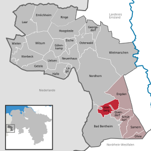
| Location of the municipality of Isterberg in the Grafschaft Bentheim district | ||
  |
||

The municipality of Isterberg is located in the Grafschaft Bentheim district in Lower Saxony .
geography
Geographical location
The community is located between Bad Bentheim and Nordhorn and is part of the Schüttorf community .
There is no actual village center. The municipality is named after the mountain of the same name , which is one of the last foothills of the Teutoburg Forest with a height of 68 meters in the municipality.
The furthest branch of the Teutoburg Forest is not located directly at the Isterberg, but ends in Gildehaus . The last trees of the Teutoburg Forest stop at Gronauer Straße, leaving Gildehaus in the direction of the Netherlands. To suggest, however, that in former times the Teutoburg forest to extending the Princely bush that the peasantry is Bardel.
Community structure
- Neerlage
- Wengsel
history
Origin of the place name
The name of the community is derived from the mountain Isterberg, which probably owes its name to a Germanic cult site. This place of worship was dedicated to the tribal god Istraz. Istraz is the nickname Wodans, the main common Germanic god. Another possible interpretation is an affiliation with "heester, Heister". Heister or Hester stands for "those who live in young beech trees".
Incorporations
Isterberg was created on March 1, 1974 from the merger of the municipalities of Wengsel and Neerlage.
politics
Municipal council
The municipal council consists of three councilors and six councilors. With a turnout of 70.66%, the only voting community of Isterberg became the sole parliamentary group in the local council.
- Distribution of seats
- Isterberg voter community: 9 seats
mayor
The mayor of the community of Isterberg elected on November 15, 2016 is Günter Wilmink. His deputies are Gabriele Feitsma and Friedrich Kleine Ruse.
Heinrich Verwold was previously honorary mayor from 2006 to 2016.
societies
There is a local YMCA (YMCA Isterberg-Quendorf), which not only serves as a meeting point for young people, but also for adults - especially older citizens.
There is also a rural youth association in Isterberg, which u. a. a famous tent festival organized in the county every year.
In the volunteer fire Isterberg many volunteers involved.
traffic
The regional bus route 40 of the Verkehrsgemeinschaft Grafschaft Bentheim (VGB) connects Isterberg with Nordhorn and Bad Bentheim every hour . There is also a regular connection to Quendorf and Schüttorf with the regional bus route 50 .
Web links
Individual evidence
- ↑ State Office for Statistics Lower Saxony, LSN-Online regional database, Table 12411: Update of the population, as of December 31, 2019 ( help ).
- ^ Jürgen Udolph (research): The "place name researcher". In: website NDR 1 Lower Saxony . Archived from the original on December 3, 2016 ; accessed on October 8, 2018 .
- ^ Federal Statistical Office (ed.): Historical municipality directory for the Federal Republic of Germany. Name, border and key number changes in municipalities, counties and administrative districts from May 27, 1970 to December 31, 1982 . W. Kohlhammer, Stuttgart / Mainz 1983, ISBN 3-17-003263-1 , p. 255 .
- ↑ a b City Council. In: Website of the municipality of Isterberg. Retrieved October 11, 2018 .
- ↑ Line network of the VGB (PDF)