
Pianella (Abruzzo)
| Pianella | ||
|---|---|---|

|
|
|
| Country | Italy | |
| region | Abruzzo | |
| province | Pescara (PE) | |
| Coordinates | 42 ° 24 ' N , 14 ° 3' E | |
| surface | 46 km² | |
| Residents | 8,577 (Dec 31, 2019) | |
| Population density | 186 inhabitants / km² | |
| Post Code | 65019 | |
| prefix | 085 | |
| ISTAT number | 068030 | |
| Popular name | Pianellesi | |
| Website | Pianella | |
 Panorama of Pianella |
||

Pianella is an Italian commune with 8577 inhabitants in the province of Pescara in the Abruzzo region .
The neighboring municipalities are: Catignano , Cepagatti , Loreto Aprutino , Moscufo , Nocciano , Rosciano and Spoltore .
Attractions
In the old town there are beautiful buildings from the 18th century such as the Palazzo de Felici or the Palazzo Sabucchi. A little off the beaten track is the church of Santa Maria Maggiore (called "Sant'Angelo" by the inhabitants) from the early to mid-12th century. In addition to beautiful frescoes, the church also has a stone pulpit from the 12th century by Master Acuto.
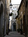
In the old City

Palazzo Comunale

Palazzo de Felici

Chiesa di Santa Maria Maggiore
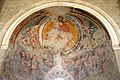
Frescoes by S. Maria Maggiore

Stone pulpit
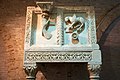
Detail view of the pulpit


,_01.jpg)

,_ambone_del_Maestro_Acuto.jpg)
,_02.jpg)
Viticulture
In the municipality of vines are varieties Montepulciano for the DOC - wine Montepulciano d'Abruzzo grown.
Web links
Individual evidence
- ↑ Statistiche demografiche ISTAT. Monthly population statistics of the Istituto Nazionale di Statistica , as of December 31 of 2019.

Abbateggio | Alanno | Bolognano | Brittoli | Bussi sul Tirino | Cappelle sul Tavo | Caramanico Terme | Carpineto della Nora | Castiglione a Casauria | Catignano | Cepagatti | Città Sant'Angelo | Civitaquana | Civitella Casanova | Collecorvino | Corvara | Cugnoli | Elice | Farindola | Lettomanoppello | Loreto Aprutino | Manoppello | Montebello di Bertona | Montesilvano | Moscufo | Nocciano | Penne | Pescara | Pescosansonesco | Pianella | Picciano | Pietranico | Popoli | Roccamorice | Rosciano | Salle | San Valentino in Abruzzo Citeriore | Sant'Eufemia a Maiella | Scafa | Serramonacesca | Spoltore | Tocco da Casauria | Torre de 'Passeri | Turrivalignani | Vicoli | Villa Celiera