Alanno
| Alanno | ||
|---|---|---|

|
|
|
| Country | Italy | |
| region | Abruzzo | |
| province | Pescara (PE) | |
| Coordinates | 42 ° 18 ′ N , 13 ° 58 ′ E | |
| height | 307 m slm | |
| surface | 32.51 km² | |
| Residents | 3,458 (Dec. 31, 2019) | |
| Population density | 106 inhabitants / km² | |
| Post Code | 65020 | |
| prefix | 085 | |
| ISTAT number | 068002 | |
| Popular name | Alannesi | |
| Patron saint | San Biagio | |
| Website | Alanno | |
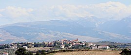
 Look at Alanno |
||
Alanno is an Italian commune in the province of Pescara in the Abruzzo region .
Location and dates
Alanno is 35 kilometers southwest of Pescara . 3458 residents live here. The districts are Alanno Stazione, Case, Catena, Colle Grande, Costa delle Plaie, Feliceantonio, Fraticelli, Gobeo, Madonnella, Maltempo, Oratorio, Pennesi, Petricca, Ponte Fara, Prati, Sperduto, Tarantolà, Ticchione and Zampetta. The neighboring municipalities are Cugnoli , Manoppello , Nocciano , Pietranico , Rosciano , Scafa , Torre de 'Passeri and Turrivalignani .
The community has a motorway connection to the A25 . There is also a small airfield ( Aviosuperficie ) for general aviation .
The city's inhabitants live from tourism and agriculture ( viticulture ).
history
The origin of the place is unknown.
Attractions
The old town of Alanno is located on a hill. There are also three medieval towers here. The church of Francis and the church of S. Maria delle Grazie are worth seeing. The church dell'Oratorio delle Grazie from the 17th century is located three kilometers outside the village.
Viticulture
In the municipality of vines are varieties Montepulciano for the DOC - wine Montepulciano d'Abruzzo grown.
Web links
Individual evidence
- ↑ Statistiche demografiche ISTAT. Monthly population statistics of the Istituto Nazionale di Statistica , as of December 31 of 2019.


