Pottschach
|
Pottschach ( district ) locality cadastral community Pottschach |
||
|---|---|---|
|
|
||
| Basic data | ||
| Pole. District , state | Neunkirchen (NK), Lower Austria | |
| Judicial district | Neunkirchen | |
| Pole. local community | Ternitz | |
| Coordinates | 47 ° 42 '12 " N , 16 ° 0' 4" E | |
| height | 427 m above sea level A. | |
| Residents of the village | 4869 (January 1, 2020) | |
| Area d. KG | 6.14 | |
| Post Code | 2630 | |
| prefix | + 43/02630 | |
| Statistical identification | ||
| Locality code | 05251 | |
| Cadastral parish number | 23360 | |
| Counting district / district | Pottschach-Mitte / Pottschach-Ost / Pottschach-Nordost / Pottschach-Nordwest / Pottschach-Süd (31839 030/032/035/031/033) | |
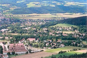
 View of Pottschach from the Gfiederwarte |
||
| Source: STAT : index of places ; BEV : GEONAM ; NÖGIS | ||
Pottschach [ˈpɔtˌʃax] is a cadastral municipality and with 5057 inhabitants the second largest town in Ternitz in the Neunkirchen district in Lower Austria . Pottschach is 427 m above sea level. A. Pottschach was an independent municipality until 1973 , before it was incorporated into the municipality of Ternitz as part of the Lower Austrian municipal reform.
geography
Pottschach is located at the southern end of the Vienna basin . It stretches from the Schwarzaufer to the foothills of the Schneeberg area . The town center is 427 m above sea level. The place borders on the municipalities of Buchbach , Bürg-Vöstenhof , Grafenbach-Sankt Valentin and Wimpassing in the Schwarzatale as well as the places Ternitz, Putzmannsdorf and Holzweg. Pottschach is bounded in the north by the Gfieder (609 m) and in the northwest by the Kohlberg (708 m). In addition, the Burgstall with the Kalvarienberg is located in the southwest.
In the east Pottschach is bounded by the Schwarza. In addition, the southern runway divides the place into a western and an eastern part.
Local division
- Altpottschach with Neudörfl and Sonnleiten
- Settlement I.
- Settlement II
- Settlement III
- C.-F.-Rüger settlement
climate
|
Average monthly temperatures and precipitation for Pottschach
|
|||||||||||||||||||||||||||||||||||||||||||||||||||||||||||||||||||||||||||||||||||||||||||||||||||||||||||||||||||||||||||||||||||||||||||||||||||||||||||||||||||||||||
history

Pottschach was first mentioned in a document in 1094. It is derived from the old word Botsaha or Botsach, which means "forbidden water" or "ban water". This means that the subjects were not allowed to fish. The place existed much earlier. Stone Age tools were found in the Pottschach area . In 600 AD there was a weir system on the Purgstall in Pottschach. Finds of old walls in the parish church have shown that there was a Carolingian church as early as the 9th century . This was rebuilt into a Gothic church around 1500 , and the 25 m high tower was built in 1520. In the 17th century the church was baroque .
The Pottschach castle was in the 16th century under Bernhard Ursenbeck as a moated castle built.
Pottschach was a municipality since 1864. The cadastral communities were Pottschach, Putzmannsdorf and Holzweg.
In the 19th and early 20th centuries, Pottschach was a popular summer resort in southern Lower Austria. This was supported by the construction of the southern railway , to which Pottschach was connected in 1842. Many summer guests either stayed in the Hotel Rabensteiner or built villas for themselves. Many of these villas are still standing in Pottschach today, testifying to a former holiday resort, the Hotel Rabensteiner has been empty for many years.
Population development
Municipality of Pottschach (cadastral municipalities of Pottschach, Holzweg and Putzmannsdorf)
- 1854: 794 inhabitants
- 1880: 1465 inhabitants
- 1934: 2368 inhabitants
- 1947: 4,320 inhabitants
- 1951: 4664 inhabitants
- 1961: 5074 inhabitants
- 1971: 5506 inhabitants
education
Elementary school
There was a school in Pottschach as early as the 16th century. Until 1880 there was a single-class elementary school. Then a multi-class elementary school was built. The Lautner cardboard factory also had Sunday school for the workers' children. As the number of pupils increased, a new elementary school was built in 1969, today's Dr. Adolf Schärf Elementary School. In 1998, an additional elementary school was built in Kreuzäckergasse, the Kreuzäckergasse elementary school.
secondary schools
In 1955 a secondary school was built in Pottschach. This still exists today and has been converted into a New Middle School (NMS).
kindergarten
Today there are three kindergartens in Pottschach:
- the Pottschach parish kindergarten
- the state kindergarten Pottschach
- the kindergarten in Kreuzäckergasse
Attractions
Parish church Pottschach
Chapels
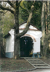
- The Kalvarienbergkapelle is the oldest chapel in Pottschach. It was donated in 1709 by Maria Anna von Geyersberg. It is located at the end of the Way of the Cross in Pottschach am Kalvarienberg.
- Anna Chapel - This chapel was built in 1775 on the outskirts of Pottschach, in Neudörfl. Palm consecration is held here every year.
- Holzwegkapelle - built in 1828 by the Niederl family.
Gfiederwarte
At the summit of Gfieders , a 609 m high mountain in Pottschach, there is a lookout point with a view of Lake Neusiedl .
graveyard
The cemetery used to be around the church. Today the cemetery is at the foot of the Kalvarienberg.
War cemetery (Russenfriedhof)
Next to Franz Samwald-Straße there is a war cemetery of the former Soviet army, which is popularly known as the "Russian cemetery". In the winter of 1945/46, this cemetery was built near what was then Ternitzer Strasse (today Franz-Samwald-Strasse) at the Wimpassing junction under the direction of a Soviet officer. The occupation authorities used people classified as National Socialists who were supervised by Soviet soldiers at work. On April 13, 1946, the 1st anniversary of the invasion of the Red Army, the grand opening of the 22 a large military cemetery took place. Many Soviet officers attended the opening, including General Zwjeitkow, who was stationed in Pottschach. 236 Soviet soldiers who died in the region are buried here.
On January 30, 1948, what was then the Pottschach community was given custody of the cemetery.
Economy and Infrastructure
Rail transport
Pottschach has been connected to the Südbahn with the Pottschach stop since 1842 , which is only served by regional trains in the direction of Payerbach-Reichenau and Vienna.
Sports
Soccer
- The "SVSF Pottschach" football club (Sportfreunde Pottschach) has existed since 1920 .
Stock sport
- 1. ESV Pottschach
- EK Elite Pottschach
- ESK Eintracht Pottschach
- ESV unity
- SG ice crystal
tennis
- 1st TC Pottschach
do gymnastics
- ATUS Pottschach
Sons of the place
- Robert Hammerstiel
- Rudolf Steiner : In his youth he lived in Pottschach for some time because his father was assigned a job here as a railway official.
- Alfons Haider : Lived in the settlement III for some time in his youth
- Helmut A. Gansterer
literature
- Walter Arlt: Pottschach then and now . City of Ternitz, Ternitz 1976.
Web links
Individual evidence
- ↑ cf. Art. I. Vienna high spring water pipeline ; Section 1938 to 1945, last sentence


