
Sakharovo (Ryazan, Sakharovsky)
| Village
Sakharovo
Zaharovo
|
||||||||||||||||||||||||||||||||||||
|
||||||||||||||||||||||||||||||||||||
|
||||||||||||||||||||||||||||||||||||
.png)
.svg)

Sakharovo ( Russian Заха́рово ) is a village (selo) in the Ryazan Oblast in Russia with 2739 inhabitants (as of October 14, 2010).
geography
The place is about 40 km in a straight line southwest of the Oblastverwaltungszentrums Ryazan on the upper reaches of the Schraka, a small left tributary of the right Oka -Nebenflusses Pronya River .
Sacharowo is the administrative center of the Rajons Sacharowski and seat of the rural community Sacharowskoje selskoje posselenije, (km west 2.5) (5 km east) are among the also the two villages Katagoschtscha and Spasskije vyselki.
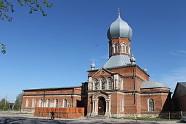
Apostle Johannes Church (1869)

School with Lenin monument

Central square of the place


history
The place was founded in 1654 by the farmer Mikhail Voronin from the 8 km northeastern village Sakharovka (today Jelino ) as an extension (Russian in the plural vysselki ). At first he was called Sakharovsky Voronji wysselki. By the 19th century the settlement reached a size similar to Sakharovka and in 1869 it became an independent village under the shortened official name of Sakharovsky vysselki. It belonged to the Wolost Popadjino - the eponymous place is in close proximity to Sakharovka / Jelino - in the Ujesd Michailow of the Ryazan governorate, which existed from 1796 .
In 1917 the place itself became the seat of a Volost. On July 12, 1929, the Sakharovsky rajon was built, the seat of which was initially in Popadjino, but was relocated to Sakharovsky vysselki on April 10, 1932. At the same time the renaming of the place in Sakharovo-1 and from Sakharovka in Sakharovo-2 took place. Since Sakharovo-2 was renamed Jelino again in the 1930s, the village is only called Sakharovo.
During the Second World War , the German Wehrmacht reached the village on November 25, 1941 as the point of their furthest advance in the direction of Ryazan, but on the same day withdrew to Mikhailov, a good 20 km south-west, which they barely reached until the Red Army counter-offensive lasted two weeks.
From 1963 to 1965 the Rajon was temporarily dissolved and its territory was divided among the surrounding Rajons.
Population development
| year | Residents |
|---|---|
| 1897 | 1754 |
| 1939 | 1684 |
| 1959 | 1418 |
| 1970 | 2185 |
| 1979 | 2767 |
| 1989 | 3174 |
| 2002 | 2956 |
| 2002 | 2739 |
Note: census data
traffic
Sakharovo is on the federal highway R132 , which leads from Kaluga via Tula and Michailow (on the R22 Kaspi ) to Ryazan (on the M5 Urals ). The nearest train station is in Mikhailov at kilometer 202 on the Moscow - Pavelets - Bogoyavlensk line .
Web links
Individual evidence
- ↑ a b Itogi Vserossijskoj perepisi naselenija 2010 goda. Tom 1. Čislennostʹ i razmeščenie naselenija (Results of the All-Russian Census 2010. Volume 1. Number and distribution of the population). Tables 5 , pp. 12-209; 11 , pp. 312–979 (download from the website of the Federal Service for State Statistics of the Russian Federation)
| Cities |
Kassimov S / R | Korablino R | Mikhailov R | Novomichurinsk | Ryazan S / R | Ryashsk R | Rybnoye R | Sassowo S / R | Schazk R | Skopin S / R | Spas-Klepiki R | Spassk-Ryazansky R. |
|
| Urban-type settlements |
Alexandro-Nevsky R | Gus-Schelesny | Jelatma | Jermisch R | Kadom R | Lesnoi | Miloslavskoye R | Oktyabrsky | Pavelets | Pitelino R | Pobedinka | Pronsk R | Saposhok R | Sarai R | Schilowo R | Staroshilovo R | Syntul | Chuchkovo R | Tuma | Ucholowo R | Zentralny |
|
| Other Rajon centers |