
Eider Canal
The Eider Canal or Eider Canal , built as the Schleswig-Holstein Canal or Schleswig-Holstein Canal , connected the Kiel Fjord near Kiel-Holtenau with the natural course of the Untereider near Rendsburg from 1784 to 1890 . Together with the Eider, the canal formed a waterway between the North Sea and the Baltic Sea for shipping .

Naming
Since the opening in 1784 - regardless of the spelling - the name Schleswig-Holstein Canal was common. The name of the canal was based on the course of the border rivers Levensau and Eider; they divided the areas of the two duchies of Schleswig and Holstein from one another. Only after the Schleswig-Holstein War (1848-1851) did the Danish royal family rename the Eider Canal in 1853 in order to hinder national efforts in the amalgamation of Schleswig-Holstein in the sense of a political term. When Danish sovereignty ended in the German-Danish War in 1864 and the Prussian province of Schleswig-Holstein was founded in 1866, the name Schleswig-Holsteinischer Kanal returned again.
requirements


As early as 1571, Duke Adolf I planned a canal to connect Kiel with the Eider and to compete with the Stecknitz Canal . However, the fragmentation of Schleswig-Holstein in the possessions of Denmark and Holstein-Gottorp was an insurmountable political obstacle. After Holstein-Gottorp was incorporated into the Danish state (in exchange for the County of Oldenburg through the Treaty of Tsarskoe Selo in 1773), a fundamental geopolitical requirement for the construction of the canal and its operation was given.
Planning
Andreas Peter von Bernstorff , head of the German law firm in Copenhagen, played an important constructive role . After the establishment of the state as a whole, an economic boom began under the sign of mercantilism . From this situation the long-cherished plan to build canals matured. As a staunch supporter of the entire Danish state, the Schleswig mayor and entrepreneur Georg Bruyn - brother of Johann von Bruyn - was a major initiator of the canal.
In 1773, engineer Wilhelm Theodor Wegener (1724–1792) - also Carsten Anker's father-in-law since 1784 - was promoted to major general and general director for surveying. In this capacity, he presented his first canal construction plan in February 1774: the cities of Husum in the west and Eckernförde in the east were intended as estuary ports. From Husum there should be a canal section to the Treene . At Hollingstedt (Treene) a second canal section would have connected the river with the Schlei . And finally there was the plan to have the municipality of Fleckeby build a third section to Eckernförde to avoid the shallows of the Schlei. Wegener's plan was not approved by the Copenhagen administration, but it accelerated further activities.
On April 14, 1774, King Christian VII of Denmark issued a cabinet order in Copenhagen to establish a Canal Commission. In the order it said:
"Since, through the providence of the Most High, we now see ourselves in the undivided possession of the Duchy of Holstein, we have, for the sake of our dear and loyal subjects, made the paternal decision to unite the Baltic Sea with the North Sea by digging a canal which, as far as nature is concerned and allow the location of the locality to be at least 5 to 6 feet deep in order to promote and expand trade and expand all branches of industry in the country. "
The royal order thus contains a reference to the necessary prerequisites for the canal construction that were achieved in 1773. Andreas Peter von Bernstorff, who was involved in the contract, was a member of the Canal Commission, which was chaired by Heinrich Carl von Schimmelmann , a businessman from Germany and a Danish treasurer . The governor responsible for the duchies, Karl von Hessen-Kassel - a friend of Wegener's - headed a local working committee at Gottorf Castle . Two other members of the Canal Commission were the engineering captains August Hinrich von Detmers (1730–1781) and Friedrich Hermann Peymann (1732–1817) - they are considered to be the actual engineers of canal construction.
In 1774, investigations into a possible route from Kiel to the Lower Elbe began . The glacial channel from Obereider, Bothkamper , Bordesholmer and Einfelder See should be used for this. After the watershed at Einfelder See, the Lower Elbe would have been reached via the two rivers Schwale and Stör .
Construction work

After the surveying work, construction began in 1776, initially with the deepening of the Eider between Friedrichstadt and Rendsburg. Overall, the Eider could be used over a length of 130 km. Construction work on the canal, which was 34 km long, began in July 1777 near Holtenau . This section partly followed the Levensau , which flowed into the Kiel Fjord before construction . In addition, at Rendsburg the Obereiderseen was included in a length of nine kilometers, so that the shipping route at that time comprised a total length of 173 km. The height difference between Kiel and the Rendsburg Obereiderseen was about seven meters, which required the construction of six locks at these locations:
- Holtenau
- Knoop
- Rathmannsdorf
- Königsförde
- Kluvensiek
- Rendsburg.
All construction work ended in the autumn of 1784. The costs amounted to 9 million marks, of which 390,000 marks were for land purchase and compensation.

Channel data
The canal had a length of 34 km, a water level width of 28.7 m, a floor width of 18 m and a depth of 3.45 m and thus a water-bearing cross-section of 83 m². Ships up to 28.7 m long, 7.5 m wide, 2.7 m deep and 140 t in weight were allowed to pass through the canal. In the good hundred years of its existence, around 300,000 ships used the canal.

Channel course
The canal ran from the Kiel Fjord on the border between the duchies of Schleswig and Holstein: The canal began in the former Levensau river bed south of the lighthouse in Holtenau , which is still standing today , past the packing house to the first lock, which is still standing today. Then south past Gut Knoop , where the second lock was. At the places of these two locks there were already bridges over the Levensau. For a short stretch the canal did not follow the Levensau further west, but ran northwest from the Achtstückeberg (23 m above sea level) to the third structure, the Rathmannsdorfer lock . With these three systems, the canal was 7 m above sea level. NN are raised. The section of the canal from Knoop to the Rathmannsdorfer lock has been preserved with the remains of the lock system.
The canal continued to the south-west around the Achtstückeberg, to reach the Levensau river bed north of Suchsdorf and to flow in this westward to the south of Gut Warleberg . Along a Landwehr (in what is now Quarnbek ) a breakthrough was built up to the Flemhuder See , with which the Eider was reached. The canal then ran further south from Gut Rosenkranz to Klein Königsförde .
After the fourth lock at Klein Königsförde, the canal continued via Gut Georgenthal to the fifth lock in Kluvensiek . This route used a long stretch of the Eider river, which led north from Klein Königsförde to Grünhorst and then south via Sehestedt to Kluvensiek. The section from Klein Königsförde via Kluvensiek to Hohenfelde is still preserved today with the remains of the lock system. From here on the canal followed the Eider river bed. At the time, this flowed directly past Schirnau , Lehmbek , Borgstedt to Rendsburg , where the sixth and last lock was located. A second packing house is located here. From Rendsburg the shipping route followed the natural course of the Eider for 130 km to its confluence with the North Sea at Tönning , where a third packing house is located.
A passage through the canal and the Eider took three or more days, in bad wind the ships were towed , that is, pulled by horses on towpaths laid out on the bank.

Packhouses
In 1783 three packing houses were built at the same time:
- at the Kiel-Holtenau lock
- at the Rendsburg lock
- in the port area of Tönning
The packing houses, which are comparable in their construction, served as storage facilities for storing and handling large quantities of goods such as B. wool, grain, coffee and salt. In addition, the functional buildings demonstrated the economic and political importance that the new waterway should have for the whole of Denmark.
All three buildings are made of bricks in a timber frame construction with three full floors and a fully developed attic. The front of each building is interrupted by a central projection in which there are loading gates. The two packing houses in Holtenau and Tönning have comparable areas; the building in Tönning has a length of 77.5 m and a width of 12.6 m and thus a storage area of approx. 4,000 m². The Rendsburger Packhaus is smaller than the other two buildings with a floor space of 29.5 m × 12.6 m.
The packing house in Tönning, which has been a listed building since September 20, 1965, has been extensively renovated. The Society for Tönninger Stadtgeschichte eV uses the first floor as an exhibition room. The packing house in Rendsburg is used commercially by a retail company.
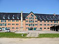
Packhouse in Kiel-Holtenau

Packhouse in Rendsburg

Packhouse in Tönning


Extension to the Kiel Canal
The Eider Canal was soon no longer able to cope with the increasing shipping traffic. The long way through the Eider and the Wadden Sea turned out to be particularly unfavorable. A large part of the Eider Canal was used for the Kiel Canal , which was then built from 1887 to 1895 . Some pieces have been straightened. In particular, two bends were cut off, the majority of which are still present as bodies of water. The remains of some old lock systems have also been preserved. Since then, the Gieselau Canal has restored the connection to the Eider.
protection


Significant parts of the Eider Canal are under protection. Since the waterway was included in the design of aristocratic estates directly on the canal in the 18th and 19th centuries, an important historical cultural landscape was created in Schleswig-Holstein. The “Alter Eider Canal at Gut Kluvensiek ” section in Bovenau with a size of 33.1 ha and since 1961 the section “Old Eider Canal, Gutspark Stift and surroundings” in Altenholz with a size of 38.3 ha have been protected landscape areas since 1939 protected. Since 1938, part of the old Eider Canal in Altenholz has been protected as a natural monument for the brown striped fern ( Asplenium trichomanes ) and the fragile bladder fern ( Cystopteris fragilis ) . Under cultural monument protection are among others Altenholz / Felm the Rathmannsdorf lock the mansion Kluvensiek the Eider canal from 1781 and the former stable building this lock (around 1780), in Bovenau of 1777/1837 with the former lock (1782/1784), the drawbridge of 1849 / 1850 and the Gutsgarten, as well as the former Eider Canal lock Klein Königsförde (1777/1784) in Krummwisch .
See also
literature
- Volker Griese : Schleswig-Holstein. Memories of History. Historical miniatures , Norderstedt 2012, ISBN 978-3-8448-1283-1 [in it the chapter: A building of the century. The creation of the Schleswig-Holstein Canal, 1777-1784 ]
- Jürgen Jensen: Kiel Canal Bridges . Boyens, Heide 2010, ISBN 978-3-8042-1309-8
- Manfred Jessen-Klingenberg : The Schleswig-Holstein Canal - Eider Canal. Prehistory, origin, meaning . In: Communications from the Kiel Society for City History . Vol. 85, Issue 3/2010, pp. 113–123 [1] (accessed July 16, 2012; PDF; 312 kB)
- Margita M. Meyer: The Old Eider Canal - A technical monument as a historical cultural landscape element . In: DenkMal! Journal for Monument Preservation in Schleswig-Holstein . Boyens, Heide 9/2002, pp. 51-58, ISBN 978-3-8042-0906-0
- Jan Schlürmann : Eider and Eider Canal in the Economic Network of the entire Danish State, 1784-1863 . In: 1200 years of the German-Danish border. Conference proceedings . Edited by Steen Bo Frandsen, Martin Krieger u. Frank Lubowitz. Neumünster 2013. pp. 197–207. ISBN 978-3-529-02865-6 .
- Gerd Stolz: The old Eider Canal - Schleswig-Holstein Canal . Published on the occasion of the 200th anniversary of its commissioning on October 17, 1784. Boyens, Heide 1989, 4th edition ISBN 978-3-8042-0297-9
- Jörg Schimmler: On the fishing use of the Eider Canal . In: Mitteilungen des Canal-Verein No. 26/2007, pp. 69–86 [2] (accessed July 4, 2014; PDF; 2.2 MB)
- Jörg Schimmler: Malaria in the construction of the Eider Canal . In: Communications from the Kiel Society for City History . Vol. 87, Issue 6/2016, pp. 270–287
- Paul Verne : Jules Verne on Eider and Canal ISBN 978-3-8042-1525-2
Individual evidence
- ^ Society for Tönninger Stadtgeschichte eV: Information sheet on the channel in the Museum of City History.
- ^ Manfred Jessen-Klingenberg: The Schleswig-Holstein Canal - Eider Canal. Prehistory, origin, meaning . In: Communications from the Kiel Society for City History . Vol. 85, Issue 3/2010, p. 116
- ^ Jürgen Jensen: Kiel Canal Bridges . Boyens, Heide 2010, p. 15
- ↑ a b c Manfred Jessen-Klingenberg: The Schleswig-Holstein Canal - Eider Canal. Prehistory, origin, meaning . In: Communications from the Kiel Society for City History . Vol. 85, Issue 3/2010, p. 117
- ↑ a b Manfred Jessen-Klingenberg: The Schleswig-Holstein Canal - Eider Canal. Prehistory, origin, meaning . In: Communications from the Kiel Society for City History . Vol. 85, Issue 3/2010, p. 118
- ^ Christiane Witte: The Tönninger Packhaus - 225 years old . Self-published, Tönning 2008, p. 2f.
- ↑ a b c d e Waldemar Jensen: The Kiel Canal. A documentation on the 75th anniversary of the opening . Chapter Prehistory of the sewer construction, page 40
- ↑ Gerd Quedenbaum, Im Spiegel der Lexika, Eider, Kanal and Eider-Canal names the data, 30 m, 16.2 m and 3 m.
- ↑ a b c d Gerd Quedenbaum, Im Spiegel der Lexika, Eider, Kanal and Eider-Canal, Düsseldorf 1982
- ^ Jürgen Jensen: Kiel Canal Bridges . Boyens, Heide 2010, p. 9
- ^ RD Marketing eV (Ed.): Treasury Rendsburg . Rensburg undated, No. 18
- ^ Christiane Witte: The Tönninger Packhaus - 225 years old . Self-published, Tönning 2008
- ^ Christiane Witte: The Tönninger Packhaus - 225 years old . Self-published, Tönning 2008, p. 3.
- ↑ Eider Canal. Garden board of the State Office for Monument Preservation Schleswig-Holstein (PDF; 603 kB)
- ↑ Ministry for the Environment, Nature and Forests of the State of Schleswig-Holstein (ed.): Explanations of the landscape framework plan for planning area III (Rendsburg-Eckernförde and Plön districts, independent cities of Kiel and Neumünster). ( Memento from April 2, 2015 in the Internet Archive ) Kiel 2000. ISSN 0935-4697
Web links
- Website of the Canal-Verein eV ( Memento from March 24, 2013 in the Internet Archive )
- The Schleswig-Holstein Canal , Schleswig-Holstein from A to Z
- The Eider Canal , Holtenau information
- Eider Canal. Garden board of the State Office for Monument Preservation Schleswig-Holstein (PDF; 603 kB)
Coordinates: 54 ° 20 ′ 36 ″ N , 9 ° 49 ′ 47 ″ E