
Diepoldsau
| Diepoldsau | |
|---|---|
 |
|
| State : |
|
| Canton : |
|
| Constituency : | Rhine Valley |
| BFS no. : | 3234 |
| Postal code : | 9444 |
| UN / LOCODE : | CH DPS |
| Coordinates : | 767 181 / 250 544 |
| Height : | 408 m above sea level M. |
| Height range : | 402–422 m above sea level M. |
| Area : | 11.25 km² |
| Residents: | 6471 (December 31, 2018) |
| Population density : | 575 inhabitants per km² |
| Website: | www.diepoldsau.ch |
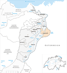
| Location of the municipality | |
  |
|

Diepoldsau is a political municipality in the cultural landscape of the St. Gallen Rhine Valley in the canton of St. Gallen in eastern Switzerland . Politically, Diepoldsau belongs to the Rheintal constituency .
geography
Diepoldsau is mostly east of the Rhine , which was rebuilt in this area with the Diepoldsau Rhine gorge as part of the regulation of the Alpine Rhine in 1923. The Old Rhine forms the border with Austria .
The political community of Diepoldsau unites the two local communities, Diepoldsau and Schmitter , which historically evolved from courtyards . The community is therefore often referred to as Diepoldsau-Schmitter . Diepoldsau borders in the west on the three Swiss communities Widnau , Balgach and Oberriet . The market town of Lustenau , the city of Hohenems and the town of Altach are directly adjacent on the Austrian side of the Old Rhine .
In addition to land in the political community of Diepoldsau, the local community Schmitter also owns land in Lustenau , Austria , the so-called "Swiss Ried". The local community of Diepoldsau in Oberriet.
history

In the year 890 the place name Thiotpoldesouva appeared for the first time in a document as a royal forest near Kriessern. The Diepoldsau area belonged to the Kriessern estate, while Schmitter belonged to the Widnau estate. In 1129 the German King Friedrich donated the Diepoldsau farm to the St. Gallen monastery.
In 1345 the three farms Au, Widnau and Schmitter formed the farm Widnau-Haslach, which was first mentioned in a document that year. It was part of the imperial court Lustenau and was subordinate to the Count of Montfort and from 1395 to the rule of the Count of Ems. Diepoldsau was first mentioned as a village in 1420. Fifty years later, in 1490, the Confederates laid hands on the Rhine Valley and exercised high jurisdiction in the part of the Widnau-Haslach court on the left bank of the Rhine under the Governor of Rheineck. In 1593 the Widnau-Haslach farm separated from the Lustenau Reich farm, but remained under the rule of the Emser. Since the area of the farm would have become too small, the farm was also given areas on the right bank of the Rhine, the "Swiss Ried".
The course of the river Rhine was recognized as the Swiss national border in 1712 and thus the residents were released from the bondage of the Hohenems counts. 1775 was the year of birth of the local community Schmitter. With the dissolution of the Widnau-Haslach farm, the land on this side and on the other side of the current course of the Rhine was divided. Each farm gets its own farm name, its own court and its own council. Seven years later the Schmitter were subordinated to the Lords of Salis-Soglio . In 1789 the Diepoldsau farm separated from the Kriessern Reich farm. In the vote, this was just accepted by the Reichshof with 63 to 51 votes. The forests of the Reichshof were now allocated to the various courts. Diepoldsau received the area of today's Diepoldsauer sponge. This still reminds us of Diepoldsau's former membership in the Reichshof Kriessern (today the municipality of Oberriet). In 1795, the Diepoldsau farm bought itself off from the St. Gallen Abbey for 1,200 guilders .
When the new canton of St. Gallen was formed in 1803, Widnau , Diepoldsau and Schmitter were combined to form the Diepoldsau political community. A little more than sixty years later, in 1868, a fire disaster struck the community. 141 people lost their homes and 23 houses burned down. Three years later one of the numerous water disasters caused by flooding of the Rhine was registered.
In 1883 Widnau became an independent political community after several years of conflict. In 1888 the Rhine was flooded, caused by a dam breach. Another dam breach followed a year later , and there was also a famine because of the destroyed harvest. The treaty between the Austro-Hungarian Danube Monarchy and Switzerland on the international regulation of the Rhine was passed in 1892.
Between 1910 and 1912, work began on the Diepoldsauer Rhine breakthrough. The First World War largely hindered the continuation of the work on the Rhine breakthrough. During the war, a large number of residents made a lot of money smuggling yarn and thread. On April 18, 1923, the Rhine was diverted to its new bed. The demolition of the dams was not immediately successful. It was felt uncomfortable that the local authorities had not been invited to this important event. In 1931 the new natural lido was inaugurated. In 1932 the municipality created the first groundwater supply with a pumping system and a pipeline network of 14 kilometers.
Before and during the Second World War , Diepoldsau was the "gateway to Switzerland" for many refugees, mostly Jews. In June 1938 a reception camp for up to 300 refugees was set up in Diepoldsau in an old, vacant ship embroidery factory. The camp was looked after by the Swiss Red Cross and financed by the St. Gallen Israelite Community. The Swiss federal government did not participate in the financing. The inmates were subject to strict camp regulations and were not allowed to work. They were forbidden from contact with the local population, but this was mostly not observed.
The old people's home in Wiednau was inaugurated in 1958, and the new pumping station for the water supply was completed four years later. In 1980 the Oberstufenzentrum Kleewies was opened .
The water supply, which was expanded for over two million Swiss francs, was put into operation in 1985. In 1988 a renovation and expansion of the old people's home was completed. In 1990 Diepoldsau celebrated its 1100th anniversary with a village festival. Four years later the new parish hall was occupied and inaugurated and in 1996 the fire station was opened . The “blue” school building in Kirchenfeld was put into operation. In the following year, the renovated and attractively developed lido on the Old Rhine was opened. The multi-purpose hall in Kirchenfeld was completed and inaugurated in 1999.
In 2000 the community had 5000 inhabitants for the first time. In 2001, the citizenship decided on the new community structure with an integrated school community in the unified community from 2005.
population

The inhabitants of Diepoldsau are called Tippilzouwer .
On December 31, 2018, Diepoldsau had a permanent resident population of 6,471 . Of these, 4,929 were Swiss citizens and 1,542 (23.82%) were citizens of other countries or did not provide any information. The gender distribution is even with 3315 men and 3156 women.
civil status
Of the 6,471 inhabitants were:
- 2805 single
- 2951 Married or in a registered partnership
- 237 Widowed or in a partnership dissolved by death
- 478 Divorced, unmarried or in a partnership dissolved by a court
origin
4,770 were born in Switzerland. 1701 were born in other countries or did not provide any information (4).
From the direct neighboring countries come from:
- Austria 367
- Germany 285
- Italy 186
- France 7
- Liechtenstein 7
Other important countries of origin are Kosovo (186), North Macedonia (142), Serbia (61), Slovakia (29), Poland (27) Turkey (26), Hungary (22), Spain (17), Bosnia and Herzegovina (16), Croatia (13), Afghanistan (13), Slovenia (12) and Eritrea (11).
economy
The flourishing embroidery industry in the St. Gallen Rhine Valley also meant the boom for Diepoldsau. Numerous small and large embroidery companies emerged. In 1873 over 80 embroidery machines were in use. In 1885 Julius Brunke (1844–1927) opened a shipping stick factory in the former Seidenspulfabrick Merian & Custer. In 1934 Brunke alone employed 134 people.
traffic
In 1788 a ferry in the Schmitter in the direction of Hohenems is mentioned. In 1873 the ferry service was stopped and replaced by a wooden bridge over the Rhine. During the war, on October 12, 1915, the Heerbrugg – Diepoldsau electric tram began operating, which in turn was converted to bus service in 1956 . The bridge over the Rhine is still called the Tram Bridge today. The Diepoldsau - Hohenems road project was approved in 1929. This road has been a very busy connection until modern times. In 1985 the tram bridge was replaced by a new cable-stayed bridge over the Rhine, which was unique at the time . On this occasion there was a big village festival.
Attractions
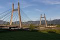
Cable-stayed bridge over the Rhine

Old Rhine

swimming pool

Parish hall

Oberstufenzentrum Kleewies

Ref. Church and Primary School Mitteldorf

Primary school Kirchenfeld and cath. church


Personalities
- Julius Brunke (* 1844; † 1927) striker manufacturer
- Benedikt Frei (* 1904; † 1975) prehistoric
- Rudolf Grob (1890–1982), Protestant clergyman and director of the Swiss Institute for Epileptics in Zurich
- Weder Brothers Johann Jakob Weder (1880–1966), Johann Anton Weder (1882–1931), Carl August Weder (1889–1932), Franz Xaver Weder (1895–1969), Johann Michael Weder (1897–1956)
- Gustav Weder (* 1961), former Swiss bobsleigh pilot
- Hans Weder (* 1946), former rector of the University of Zurich
Web links
- Official website of the community of Diepoldsau
- Markus Kaiser: Diepoldsau. In: Historical Lexicon of Switzerland .
Individual evidence
- ↑ Permanent and non-permanent resident population by year, canton, district, municipality, population type and gender (permanent resident population). In: bfs. admin.ch . Federal Statistical Office (FSO), August 31, 2019, accessed on December 22, 2019 .
- ↑ Land cover statistics: Land cover (NOLC04) by district and municipality, in hectares. (PDF) Swiss Confederation, 2009, accessed on November 14, 2019 .
- ^ Local community Schmitter land property Austria
- ^ Municipality of Oberriet property of the municipality of Diepoldsau
- ↑ Courage to Humanity , SRF MySchool, April 28, 2015
- ↑ www.erinnern.at Gerhard Wanner Refugees and border conditions in Vorarlberg 1938–1944
- ^ STAT-TAB: The interactive statistics database, population development by region, 1850–2000. Swiss Confederation, accessed on January 7, 2014 .
- ↑ STAT-TAB: The interactive statistics database, population status. Swiss Confederation, accessed on June 19, 2017 .
- ↑ Permanent and non-permanent resident population according to institutional classifications, nationality (category), gender and age. Swiss Confederation (FSO), accessed on November 14, 2019 .
- ↑ a b Permanent and non-permanent resident population by institutional structure, gender, marital status and age group. Swiss Confederation (FSO), accessed on November 14, 2019 .
- ↑ a b c Permanent and non-permanent resident population by institutional structure, place of birth and nationality. Swiss Confederation (FSO), accessed on November 14, 2019 .
- ^ Peter Müller: Rheintaler heads . Historical-biographical portraits from five centuries. Ed .: Association for the History of the Rhine Valley. Rheintaler Druckerei und Verlag AG, Berneck 2004, ISBN 3-03300265-X , Julius Brunke (1844–1927), Diepoldsau, p. 118 .
- ↑ Bruno Ender: Berneck 1100 years after the first documentary mention . Ed .: Political Community Berneck. Rheintaler Druckerei und Verlag AG, 1992, external connections, p. 70 .