
Steinlach
| Steinlach | ||
 Source of the right source branch Eckentalbach |
||
| Data | ||
| Water code | DE : 238158 | |
| location |
Middle calf
Foreland of the central Swabian Alb
|
|
| River system | Rhine | |
| Drain over | Neckar → Rhine → North Sea | |
| source | Right side valley of the Eckentalbach east of Mössingen- Talheim 48 ° 22 '52 " N , 9 ° 7' 43" E |
|
| Source height | approx. 710 m above sea level NHN | |
| muzzle | near Tübingen in the Neckar Coordinates: 48 ° 31 '4 " N , 9 ° 3' 44" E 48 ° 31 '4 " N , 9 ° 3' 44" E |
|
| Mouth height | approx. 317.5 m above sea level NHN | |
| Height difference | approx. 392.5 m | |
| Bottom slope | approx. 15 ‰ | |
| length | 25.9 km | |
| Catchment area | 141.899 km² | |
| Discharge at the Tübingen A Eo gauge : 138 km² Location: 3.4 km above the mouth |
NNQ (07/31/1972) MNQ 1962/2009 MQ 1962/2009 Mq 1962/2009 MHQ 1962/2009 HHQ (06/23/1975) |
37 l / s 260 l / s 1.75 m³ / s 12.7 l / (s km²) 42.9 m³ / s 157 m³ / s |
|
Tributaries and hydraulic structures
|
||||||||||||||||||||||||||||||||||||||||||||||||||||||||||||||||||||||||||||||||||||||||||||||||||||||||||||||||||||||||||||||||||||||||||||||||||||||||||||||||||||||||||||||||||||||||||||||||||||||
The Steinlach is an approximately 25 km long right tributary of the Neckar with a catchment area of 138 km².
geography
course
The Steinlach springs east of Mössinger district Talheim and west of Ruchberges to about 710 m above sea level. NN in a north-eastern side valley of the Eckenbachgraben , a gorge between five and ten meters deep below the eaves of the Swabian Alb . The spring outlet of the somewhat longer left upper course from the Eckenbachgraben shifts with the karst water level of the Swabian Alb. The sources of both branches are still in the municipality of Sonnenbühl .
The Steinlach enters the Steinlachtal valley in the foothills of the Alb near Talheim and is then reinforced by the Weiherbach, which is longer at the mouth and also has a much more catchment area. It now flows approximately northwest, takes on the Öschenbach from the right one kilometer before Mössingen and then crosses Mössingen on the west course. After the equally impressive Tannbach in Ofterdingen has flowed from the south-south-west , it initially follows its direction of flow. But even from the Nehren mill, which is isolated by the water, it flows steadily northwards to the mouth. After the next town, Dusslingen , its largest tributary, the Wiesaz, flows from the right near its powder mill . In the following short valley section, forest heights move left and right close to the run for the first time since Talheim; the Ehrenbach coming from Ohmenhausen joins from the right on this stretch at the Bläsibad . On the now straightened course through the Tübingen district of Derendingen and finally through the southern part of the city center of Tübingen, it reaches the Neckar, which it is about 317.5 m above sea level. NHN joins less than half a kilometer below the Neckar Island from the right.
The Steinlach flows through its almost 26 km long path, which has a mean slope of 15 ‰, about 393 meters below its source.


Catchment area
The Steinlach drains almost 142 km² on the Albtrauf around Mössingen and Gomaringen and in the Alb foreland north to the Neckar. Its catchment area borders on its northeast side a little upstream of the confluence with the catchment area of the Echaz , the next big right Neckar tributary. The main European watershed from the Rhine on this side to the Danube on the other side runs along the south-east side of the Albtrauf ; the Lauchert, with its tributaries and sometimes long underground karst tributaries , is a direct competitor to the Danube . Behind the short southwestern watershed, the Starzel now runs back to the Neckar above the Steinlach. The following neighboring rivers behind the north-western (???), of which only the Katzenbach and possibly also the Bühlertalbach are of some importance, drain the forest area of the Rammert , which extends on this side to the mouth of Tübingen.
The greatest heights are all on the Albtrauf on the southeastern watershed, where the terrain is rarely below 800 m above sea level. NN falls. The Monkberg south of Talheim above the headwaters of the Wangenbach reaches 884.4 m above sea level. NN , the second highest Bolberg left above the valley slope of the upper Öschenbach 880.8 m above sea level. NN .
Tributaries
Direct tributaries from the source to the mouth.
- Eckentalbach (longer left and east source branch)
- (Bach from the Tierental ), from the left and southeast at the tree line before Talheim, 0.7 km
- Kirchbach , from the right and east-northeast in Talheim, 1.1 km
- Weiherbach , from the left and southwest on the western edge of Mössingen - Talheim , 3.3 km and 9.3 km²
- Gässlesgraben , from the left and west-southwest to the Steinlachmühle, 0.9 km
- Seebach , from the right and east to 531.3 m above sea level. NHN immediately after the previous one, 4.1 km and 3.5 km²
- (Bach from the Buchenstelle ), from the left and southwest near the brickworks of Mössingen, 1.4 km
- Öschenbach , from the right and a total of east, 8.4 km and 12.3 km²
- Linsenbach , from the left and southwest just before Mössingen, 1.3 km
- Bachsatzgraben , from the right and east-northeast to the lower mill of Mössingen, 1.6 km
- Tannbach , from the left and southwest on the southern edge of Ofterdingen, 8.7 km and 20.7 km²
- (Bach vom Banweg ), from the left and west-southwest in southern Ofterdingen, 1.0 km
- Ehrenbach (!), From the right and southeast on the northeastern edge of Ofterdingen, 0.9 km
- (Bach from the Bienwund ), from the left and southwest opposite the Nehrener Mühle, 2.2 km
- Wiesbach or Oberwiesbach (!), From the right and in total southeast at the sports fields on the southern edge of Dusslingen, 4.7 km and 5.8 km²
- Lachen , from the left and southwest in Dußlingen, 2.0 km
- Oberwiesbach (!), From the right and south-southeast in Dußlingen, 2.1 km; arises near the course of the previous Wiesbach
- Wertgraben , from the left and west-southwest in Dußlingen almost compared to the previous one, 2.1 km
- Weilersbach , from the left and west in Dußlingen, 2.4 km
- Rahnsbach , from the left and southwest between the last commercial buildings in Dußlingen, 2.6 km
- Wiesaz , from the right and southeast near the powder mill of Dußlingen, 17.5 km and 38.7 km²
- Herrenbach or Ehrenbach (!), From the right and east-southeast to the sewage treatment plant of Dusslingen, 7.0 km (with the left upper course Kalter Brunnen ) and 9.6 km²
- → (exit of the Mühlbach ), to the left in the industrial park on the southern edge of Derendingen, 4.0 km; flows into the flood ditch next to the Neckar opposite the Neckar Island in Tübingen
- (Inflow from Bläsiberg), from the right and east a few meters after the previous one, 0.6 km
- Bläsibach , from the right and east, 1.4 km
- (Waldbach vom Hohen Lehen ), from the right and northeast in the Derendinger garden city, 1.2 km
- Kaisersbrücklesgraben , from the right and east-northeast at the river bridge on Waldhörnlestrasse, 0.8 km
geology
The Steinlach has contributed to the formation of the Swabian layered landscape through retreating erosion . On its way into the Neckar Valley, it cuts its way into all rock layers from the White Jura down to the reed sandstone, the Stuttgart formation of the Keuper . Waterfalls occur on morphologically hard rock layers , for example at the Untere Mühle near Mössingen and northeast of Ofterdingen not far from the sawmill. At Mössingen it cuts through several meters thick periglacial limestone gravel cover, which probably led to the formation of the name Steinlach . It runs through narrow valley areas in particular in the Mössingen urban area and north of the powder mill. The Steinlach flows in a curved course through the Mössing gravel plain and later sinks into the layers of the Black Jura below . At the powder mill it has cut through the layers of the Stubensandstein ( Löwenstein Formation ), but there it already runs in a wide notched valley . At its mouth, it deposited an expansive gravel fan that pushed the course of the Neckar to the north and on which parts of today's Tübingen Südstadt were built. The sedimentation of this estuary slowed down the discharge and led to the filling of the Sohlenkerbtal up to Dusslingen. In Ofterdingen the Steinlach flows on the Arietenkalkbank , which slopes slightly to the southeast , a fossil-rich layer of the Black Jura, Lias Alpha. A section of the creek bed between Schillerstrasse and Uhlandstrasse has been placed under protection as a geological natural monument of Ofterdinger Schneckenpflaster , as there are particularly many stone cores of the ammonite Arietites bucklandi on the surface. The entry of the Steinlach into the layers of the Lias Alpha near Ofterdingen caused the course to be deflected to the northeast and created the waterfall below the village.
Significance for the settlement
Due to the humid climate with abundant rainfall spread over the year and the associated almost constant regional water donation, numerous old Germanic localities were founded along the Steinlach (Mössingen, Ofterdingen, Dußlingen). The Germanic farmer clans used the Steinlach for drinking and industrial water purposes and as a receiving water for their sewage. Because the Steinlach had permanent water and there are steep sections on it, mills settled on its banks early on. With the beginning of industrialization , industries with high water and energy requirements, such as B. textile companies, later also chemical industry.
Water abstraction and the discharge of waste water had a major impact on the Steinlach water regime and reduced its water quality . The protection of the traffic routes in the Steinlachtal and the Tübingen Südstadt from Steinlach floods made it necessary to straighten the previously natural course of the Steinlach between Dußlingen and Tübingen and thus to impair it in the long term. The concreting of the Steinlach bed within Ofterdingen, which was carried out in the 1970s, also served to protect against flooding. At the same time, the mechanical-biological collective sewage treatment plant of the wastewater association of the Steinlach neighboring communities south of Derendingen was built as well as numerous rainwater retention basins. The water quality of the Steinlach could be improved, flood peaks could be smoothed. However, the water donation of the Steinlach decreased, which has a negative effect on the water regime of the creek, especially during dry periods. The water withdrawal, z. B. for the water supply of gardens, is then usually prohibited by the authorities.

vegetation

Characteristic of the Steinlach are the rows of trees planted on their banks, made of the same old, mostly 30 meter high Canadian poplars ( Populus X canadensis ). Most of them come from the poplar trees planted in 1910 at the Eckhof near Dußlingen and were used to fortify the banks of the Steinlach. They shape the landscape of the Steinlachtal, especially in autumn , when their leaves turn golden. Rows of maple trees have also been laid out on both sides of the straightened Steinlach in Derendingen. Near-natural alder-ash-stream floodplain forests or willow galleries are only available in fragments on the Steinlach. The Ahorn-Ash Gorge Forest on the steep slopes of the Enkenbachgraben in the source area of the Steinlach is an example . The perennial silver leaf ( Lunaria rediviva ), a perennial typical of canyon forests in Central Europe , forms a dark purple blooming aspect in this canyon forest in early spring.
natural reserve
- The so-called snail pavement - huge fossil ammonites and oyster mussels around 100 m long and 4 m wide - in the Steinlach stream bed in Ofterdingen has been protected as a geological natural monument for several decades. Since September 2016 it has been recognized as an important geotope and geopoint of the UNESCO Geopark Swabian Alb . In 2019 it was included in the circle of National Geotopes .
- The Steinlach waterfall near Ofterdingen and its surroundings have been a natural monument since 2010.
High water levels
Historical water marks are used for the Tübingen gauge , i.e. shortly before the confluence with the Neckar from June 23, 1975 (2.75 m), June 10, 1980 (2.58 m) and August 11, 2002 (2.33 m) called.
Others
- The venue of TSV Ofterdingen is called Steinlach Stadium due to its location in the floodplain .
- Steinlach-Bote is the name of the local section of the Südwest Presse that is common in the Steinlachtal; named after the Steinlach.
- The adjacent drawing by Eduard von Kallee shows that the Steinlach served as a motif for artistic representations from an early age.
More pictures

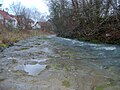
View from the bridge in Bachgasse to the Steinlach in Mössingen
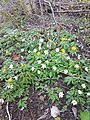
Wood anemones and yellow anemones on the banks of the Steinlach in Mössingen

Wild garlic occurs on the Steinlach in Mössingen, in the background the Pausa area
Snail plaster , clearly visible impressions of the ammonites (Ammonoidea), extinct subgroup of the cephalopods
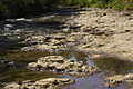
Steinlach in Ofterdingen with snail pavement

Steinlach flood in Tübingen, summer 1985
Rock blocks brought into the straightened Steinlach in Tübingen have improved their ecology

Steinlach in Tübingen taken from the wooden bridge in the southern part of the city at night looking south


See also
Individual evidence
- ^ Friedrich Huttenlocher , Hansjörg Dongus : Geographical land survey: The natural spatial units on sheet 170 Stuttgart. Federal Institute for Regional Studies, Bad Godesberg 1949, revised 1967. → Online map (PDF; 4.0 MB)
- ↑ Friedrich Huttenlocher : Geographical Land Survey: The natural space units on sheet 178 Sigmaringen. Federal Institute for Regional Studies, Bad Godesberg 1959. → Online map (PDF; 4.3 MB)
- ↑ According to LUBW-FG10 (data record entry).
- ↑ Sum of the sub-catchment areas according to LUBW-GEZG (data record entries).
- ^ German Hydrological Yearbook Rhine Region, Part I 2009 State Institute for Environment, Measurements and Nature Conservation Baden-Württemberg, p. 111, accessed on January 22, 2016 (PDF, German, 1.85 MB).
- ↑ Ofterdinger Ammonitenpflaster , on touren.tuebinger-umwelten.de, accessed on July 30, 2020
Web links
- Level map with Steinlach level near Tübingen and master data on the website of the flood forecast center Baden Württemberg
-
Geoportal Baden-Württemberg ( information ), especially with the partial maps / layers
- the State Institute for the Environment, Measurements and Nature Conservation Baden-Württemberg (LUBW)
- "LUBW-FG10": River 1: 10,000
- "LUBW-SG10": Standing water 1: 10,000
- "LUBW-GEZG": water catchment areas
- the State Institute for the Environment, Measurements and Nature Conservation Baden-Württemberg (LUBW)
- Map of the Steinlachlauf on: State Institute for the Environment Baden-Württemberg (LUBW) ( information )