South East Queensland
| South East Queensland | |
 Overview of the regions of Queensland (South East Queensland on the map as Brisbane and Moreton) |
|
| structure | |
| State : |
|
| State : |
|
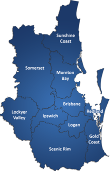
| LGA : | Brisbane , Gold Coast , Ipswich , Lockyer Valley , Logan , Moreton Bay , Redland , Scenic Rim , Somerset , Sunshine Coast |
| Dates and numbers | |
| Area : | 22,420 km² |
| Residents : | 3,050,000 (2010) |
| Population density : | 136 inhabitants / km² |
Coordinates: 27 ° 0 ′ S , 152 ° 0 ′ E
South East Queensland (abbreviated SEQ) is a region in Queensland, Australia, in which 3.05 million people live, out of a total Queensland population of 4.6 million in 2011. The SEQ region extends over 22,420 km² and contains 10 LGAs ; it extends 150 miles from Noosa in the north to the Gold Coast and the New South Wales border in the south (some sources include Tweed Heads , which is connected to the urban area of Brisbane and Gold Coast, as well as that to the west, 140 km Toowoomba (unofficial part of SEQ)).
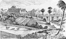
South East Queensland was the first area of Queensland to be explored and settled by Europeans.
The economy of South East Queensland is based on and fueled a wide variety of diverse agricultural industries, commerce and tourism. The region is accessed by an integrated public transport system, the TransLink .
Territory definition
Geographically
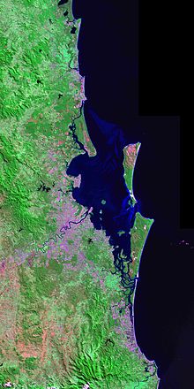
The geographic definition of South East Queensland is the coastal river basin that stretches from the New South Wales border to the Mary River catchment area . The western border forms the watershed of the Great Dividing Range , the continental division of Australia.
Politically
The term South East Queensland has no political meaning. This area holds elections for multiple seats in the state and central Australian state. Since Queensland does not have a House of Lords, there are no Legislative Council Provinces or Regions bearing that name.
administration
There is confusion about what exactly is South East Queensland, with its multiple equal central and federal administrations. The same geographic definition is rarely used and different definitions are often used.
history
South East Queensland was the traditional land of 20,000 Aborigines at the time of James Cook's 1770 voyage along the east coast of Australia . According to historical studies, the indigenous population fell to 10,000 in the following 60 years.
The first European explorers to break into this area were Matthew Flinders , Allan Cunningham , John Oxley and Patrick Logan . The first settlers came to this region around 1839. Logging was the first industry to develop. The first rail link built in Queensland connected Grandchester with Ipswich with a gauge of 1067 mm in 1865.
Major floods occurred in this area in 1893, 1974, and 2010-2011 . In 2005 the region suffered the longest drought in its history.
Demographics
In 2011, the population of South East Queensland was estimated at approximately 3.05 million people, meaning that this area is the most populous area in Australia. The regional population is highly urbanized and concentrated along the coast. The three most populous centers are Brisbane, Gold Coast and Sunshine Coast, where 90 percent of the regional population is concentrated.
Regions and Local Government Areas
South East Queensland generally consists of the following regions, each of which is also a Local Government Area :
-
Brisbane : the capital and largest city of Queensland. The metropolis of Brisbane consists of the City of Brisbane , as well as the following LGAs:
- Ipswich City : a suburb with an industrial and mining history west of Brisbane.
- Logan City : a large residential area between Brisbane and the Gold Coast
- Moreton Bay Region : a large residential area between Brisbane and the Sunshine Coast
- Redland City : a residential and agricultural area on the coastline from Moreton Bay to southeast Brisbane
- Gold Coast City : the tourist center and recreation area south of Brisbane and the largest city that did not become a capital in Australia
- Sunshine Coast Region : a tourist coastal region and an agricultural region in north Brisbane. The Glass House Mountains are the symbol of this region.
-
West Moreton : an agricultural area in the Great Dividing Range . It consists of:
- Lockyer Valley Region : a rural area west of Ipswich known for its fruit and vegetable production
- Scenic Rim Region : an inland rural area of the Gold Coast known for its idyllic mountains and villages
- Somerset Region : a rural area west of Brisbane and an area with two dams providing water to South East Queensland . This area is also known as the Brisbane Valley .
The Tweed Shire is currently part of New South Wales, but it is often incorporated into SEQ's planning processes. Since it is not an official part of the public transport system, the buses to the surf stands run seamlessly across the border, so that passengers assume that it is integrated.
Significant places
South East Queensland includes the following major regional locations:
- Brisbane , the capital of Queensland and its largest city
- Gold Coast, Queensland's premier tourist destination and surfing mecca in south Brisbane.
- Sunshine Coast , another major tourist area in north Brisbane.
- Ipswich, Queensland's oldest city and industrial center in southwest Brisbane.
- Logan , a town between Brisbane and the Gold Coast that consists mostly of housing and some light industry.
Airports
- Brisbane Airport - The region's largest international airport with direct flights to California , Asia , Oceania and the Middle East .
- Gold Coast Airport - the region's second largest airport is one of the fastest growing airports. The airport has flight connections to Japan, Malaysia and New Zealand.
- Sunshine Coast Airport - a domestic airport with lines to Sydney and Melbourne .
- Archerfield Airport - a general airport located approximately seven miles south of downtown Brisbane.
- Redcliffe Airport - a general airport located on the Redcliffe Peninsula and located approximately 17 miles from downtown Brisbane.
- RAAF Base Amberley - Australia's largest Air Force base of operations , located southwest of Ipswich and approximately 50 km from downtown Brisbane.
Immigration and population growth
South East Queensland is one of the fastest growing regions in Australia. The state's growth is primarily the result of immigration from the southern states and from overseas. In 2010, the population of South East Queensland grew an average of 1,200 new people per week.
The region has seen significant population growth over the past two decades, with an average of 55,000 to 80,000 people per year since 1986. South East Queensland is expected to have a population of 4.4 million by 2031. A 2010 report estimates the region will have a population of 5.5 million people by 2051.
Regional planning
The future development of South East Queensland is heavily based on the South East Queensland Regional Plan developed by the Queensland Government in 2005. This regional plan extends from 2009 to 2031 and focuses the slow development along the coast, taking into account the 200 km long city of Brisbane, and provides support for growth in the west, especially around Springfield and Beaudesert .
environment
Landscapes dominated by rural areas lie in the west of the urbanized coastal centers. The Lockyer Valley , a significant agricultural area, is known as the South East Queensland's Salad Bowl (German: Salatschüssel von South East Queensland ), which is located outside of Brisbane. Numerous world heritage listed rainforests are located along the southern border of the mountains, an area called the Scenic Rim , which includes , for example, Lamington National Park and Main Range National Park .
The koala is listed as endangered in the region. The Australian Koala Foundation says this animal is being displaced by mining and building land development. A dramatic decline has been noted around Redland City in recent years. The state government issued a Koala Conservation Plan in 2006 . This plan aims to rehabilitate developed areas, contain local dogs and signposts for koalas. Another initiative from 2010 envisaged the rehabilitation of the koala's habitats by planting trees and building koala-friendly fences.
Web links
- SEQ History History of South East Queensland
- South East Queensland Council of Mayors .
Individual evidence
- ^ A b c Regional Population Growth, Australia, 2010-11 ( Memento April 5, 2012 in the Internet Archive ). Australian Bureau of Statistics. Retrieved March 31, 2012.
- ^ Tony Moore: Joh-era politics? Not yet, says Aboriginal historian . In: Brisbane Times , Fairfax Media, May 19, 2012.
- ^ History of Rail in Australia . Department of Infrastructure and Transport. Retrieved May 19, 2012.
- ^ Construction of our projects . WaterSecure. Archived from the original on August 11, 2012. Retrieved on May 19, 2012.
- ^ South East Queensland Regional Plan - Part B: Growth management ( August 19, 2006 memento in the Internet Archive ). Retrieved January 21, 2007.
- ↑ Peter Hutson, Mark Saunders, Phillip Kohn & John Merrick: Human settlements: Population and settlement patterns , Department of Environment and Resource Management. February 13, 2008. Archived from the original on April 5, 2011. Retrieved on March 31, 2012.
- ^ Population growth highlights and trends Queensland 2011 , Queensland Treasury. September 2011. Archived from the original on February 24, 2014. Retrieved March 31, 2012.
- ^ South East Queensland - Department of Infrastructure and Planning ( Memento April 6, 2008 in the Internet Archive )
- ↑ Marissa Calligeros: 'Fortress Queensland': population cap blasted . In: Brisbane Times . Fairfax Media. March 25, 2010. Retrieved March 31, 2012.
- ↑ a b (December 7, 2011). dlgp.qld.gov.au ( March 19, 2012 memento in the Internet Archive ): South East Queensland Regional Plan of the Department of Local Government and Planning. Retrieved March 31, 2012.
- ↑ Darren Cartwright: Activists can't bear Newman's koala protection plan . In: Sydney Morning Herald , Fairfax Media, March 11, 2012. Retrieved March 31, 2012.
- ^ A b Nadine McGrath: Koalas 'in crisis' in South East QLD . In: Brisbane Times , September 9, 2007. Retrieved March 31, 2012.
- ↑ Tom Forbes & Nicole Jacobi: Koala habitat plan seen as good start . In: ABC News , Australian Broadcasting Corporation, February 25, 2010. Retrieved March 31, 2012.


