Satellite town
Satellite towns (also known as satellite settlements ) are economically relatively independent settlements in the vicinity of a larger city . In contrast to the satellite city , which is predominantly dominated by the residential function, they are characterized by a higher job density and their own infrastructure. In contrast to satellite cities, the commuter balance is lower due to the fact that there are jobs available.
The definition of the terms satellite town and satellite town is controversial, whereby the more widespread classification is followed, which is also followed by Burkhard Hofmeister , the author of the standard work "Urban Geography", and which is more common internationally. Rudolf Hillebrecht and Heineberg, the author of the work “Outline of General Geography: Urban Geography”, use the two terms in exactly the opposite way.
A satellite town is like a full-fledged medium-sized town in the vicinity of a large city. Meanwhile, the satellite city is more of a dormitory city that many residents leave in the morning for the big city and return to after work. Both city forms are therefore located in the vicinity of a larger city, but represent different concepts in terms of the basic idea.
Satellite cities and settlements are often built on “ green fields ”, that is, on areas that were not previously part of the settlement area of the city or municipality. This usually requires reallocation of land that was previously mostly used for agriculture in building land under building law ; Such re-zoning processes and the resulting often enormous increase in the value of the land or property concerned are often described with the ironic phrase “ fifth crop rotation ”.
Examples of satellite cities
Brazil
- the Barra da Tijuca neighborhood in southwest Rio de Janeiro
Europe
- the suburb of Hässelby-Vällingby in the north-west and Skarpnäck in the south of Stockholm
- many cities in the Parisian banlieue such as Sarcelles Marne-la-Vallée , Évry , Cergy-Pontoise (see also ville nouvelle )
- the Petržalka district in the south of Bratislava , supposedly the largest prefabricated housing estate in Europe
- Jižní Město (Südstadt), the largest prefabricated housing estate in Prague with around 80,000 inhabitants
- Tychy in the Upper Silesian industrial area south of Katowice
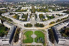
- Nowa Huta in the east of Krakow
Germany
- East German large housing estates
- Berlin - Hellersdorf
- Berlin- Marzahn
- Berlin- Neu-Hohenschönhausen
- Halle - Neustadt
- Halle- Silberhöhe
- Hoyerswerda - Neustadt
- Jena - Lobeda
- Leipzig - Grünau
- Rostock - Lütten Klein
- West German large housing estates
The construction of large West German housing estates was mostly started in the 1950s and 1960s due to the housing shortage after the Second World War. Large residential projects were also started in the 1970s. In some cases, such as in Nürnberg- Langwasser , the development phase lasted several decades.
- Berlin - Gropiusstadt
- Berlin- Märkisches Viertel
- Bielefeld - Sennestadt
- Braunschweig - Weststadt
- Bremen - Vahr
- Frankfurt - Northwest City
- Hamburg - Mümmelmannsberg
- Hamburg-Steilshoop
- Kiel - Mettenhof
- Cologne - Chorweiler
- Mannheim - Vogelstang
- Munich - Hasenbergl
- Munich- Neuperlach
- Nuremberg - Langwasser
- Ratingen - West , north of Düsseldorf
- Wolfsburg-Detmerode
See also
Individual evidence
- ^ Michael Rieke: Seydlitz Geographie Oberstufe . Schroedel, Braunschweig 2006.
- ↑ Boris Herrmann: Rio de Janeiro - Olympia threatens an unprecedented chaos. In: Süddeutsche Zeitung , June 19, 2016.
- ^ Ewald Gläßer, Rolf Lindemann, Jörg-Friedhelm Venzke: Northern Europe. Scientific Book Society, Darmstadt 2003, p. 40.
- ↑ Konrad H. Jarausch: From the ashes. A new history of Europe in the 20th century. Reclam, Ditzingen 2015.
- ↑ Werner Zettelmeier: University development and university policy in France since 1988. In: France yearbook 1992. Politics, economy, society, history, culture. Leske + Budrich, Opladen 1992, pp. 169-184, at p. 175.
- ^ Wenzel Müller: A Sunday in the prefabricated building area. 60 km from Vienna: a strange world. In: Augustin , March 30, 2016.
- ↑ Katharina Wiegmann: City of Dreams. In: Prager Zeitung , October 12, 2016.
- ^ Ekkehard Buchhofer: Structural change in the Upper Silesian industrial area under the conditions of a socialist economic order. Kieler geographische Schriften, Volume 46. Geographical Institute of the University of Kiel, 1976, p. 199.
- ^ Gerhard Hanak, Inge Karazman-Morawetz, Krzysztof Krajewski: Global fears, fear of crime and the disorder of the city. Insecurity in Krakow and Vienna. In: Klaus Sessar u. a .: Big city fears - Anxious cities. Lit Verlag, Vienna / Berlin 2007, pp. 69–98, on p. 78.


