US Highway 97
| map | |
|---|---|

|
|
| Basic data | |
| Overall length: | 663 mi / 1067 km |
| Opening: | 1927 |
| States: |
California Oregon Washington |
| Starting point: |
|
| End point: | BC 97 on the Canadian border |
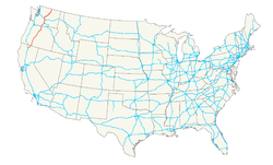
The US Highway 97 is a north-south route in the western United States . It begins on Interstate 5 in Weed , California , runs through Oregon and finally ends on British Columbia Highway 97 on the Canadian border in Washington state . Part of the route in California and Oregon is part of the Volcanic Legacy Scenic Byway . Its total length is 1067 kilometers.
US Highway 197 joins the street between Shaniko and Dallesport .
Highway 97 on the coast of Klamath Lake
Wind service on Highway 97 south of Bend
Crooked River High Bridge , formerly part of Highway 97, now replaced by the Rex T. Barber Veterans Memorial Bridge
Web links
Commons : US Highway 97 - Collection of Pictures, Videos, and Audio Files
- End of US Highway 97 (English)


