
Difficult
|
Difficult
City of Zuelpich
Coordinates: 50 ° 38 ′ 37 " N , 6 ° 38 ′ 48" E
|
|
|---|---|
| Height : | 187 m above sea level NHN |
| Area : | 7.32 km² |
| Residents : | 1605 (December 31, 2018) |
| Population density : | 219 inhabitants / km² |
| Incorporation : | 1st July 1969 |
| Incorporated into: | Veytal |
| Postal code : | 53909 |
| Area code : | 02252 |
 St. Dionysius Church
|
|
Schwerfen is the second largest district of Zülpich in the Euskirchen district in North Rhine-Westphalia . Michael Sita holds the honorary position of the mayor . (As of July 2017). The town includes Irnich Castle and the hamlet of Virnich .
location
Schwerfen is located at the transition between the Voreifel and Zülpicher Börde in the southernmost part of the city. Neighboring towns are Bürvenich , Sinzenich , Enzen as well as Gehn and Floisdorf , which both belong to the city of Mechernich . The federal highway 477 runs on the eastern edge of the village . Landesstraße 11 and Kreisstraße 10 meet in the middle of the village . The Rotbach flows through the village.
history
The place is mentioned for the first time as Sueruene in 1147 . A wealthy family was called "von Schwerfen". Their headquarters was the Gülichsburg . Further architectural monuments are the Irnicher Hof, Irnich Castle , the Virnich Court, the Virnich Knight's Seat, the Fronhof and the Church .
On July 1, 1969, the law to reorganize the district of Euskirchen merged the previous communities of Antweiler , Kommern , Lessenich-Rißdorf , Obergartzem , Satzvey-Firmenich , Schwerfen, Wachendorf and Weiler am Berge to form the new community of Veytal . With the Aachen law of December 14, 1971, the Schleiden district was incorporated into the Euskirchen district on January 1, 1972. At the same time, the municipality of Veytal (with the exception of the district Schwerfen, which came to the city of Zülpich) was incorporated into the municipality (now the city) of Mechernich.
church
The current church was built between 1891 and 1893. The quarry stone choir with buttresses has been preserved in the new building at a height of about 2 m; the newly built tower on the north side of the choir stands on the foundations of the old tower. The church is under the patronage of St. Dionysius .
The parish of Schwerfen was first mentioned in 1229. On August 23, 2009, the last pastor left the community.
societies
The local associations formed a committee many years ago. This committee is affectionately known in the village as the “local cartel” and is not an association in the true sense of the word. Every association sends its representative, usually the 1st chairman, to this committee every three months, so that joint projects and dates can be agreed. The interests of the village are discussed here so that all clubs pull together. The village festivals Tanz in den Mai , Kirmes and the Altenfahrt are organized by the cartel. The club life in the place is shaped by the following clubs and groups.
- Village beautification association Schwerfen e. V.
- Zülpich volunteer fire brigade, Schwerfen fire fighting group
- Women's community St. Dionysius e. V.
- Municipal building association St. Dionysius e. V.
- Youth Schwerfen 1993 e. V.
- Church choir Cäcilia
- Carnival Society "Schwerfe bliev Schwerfe" 1947 e. V.
- Schützenbruderschaft St. Sebastianus Schwerfen e. V.
- St. Dionysius Seniors Club
- Senior dance group
- Spiel und Sportclub Schwerfen e. V.
- Tambourkorps Eifeltor e. V.
- Tennis Club Schwerfen e. V.
- "We for Schwerfen" Förderverein 2012 e. V.
Personalities
- Thomas Eßer (1870–1948), publisher and politician born in Schwerfen. The village square in Schwerfen and a vocational school in Euskirchen are named after him.
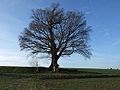
Eichbaum

Matthias stele


Others
- The town has an integrative urban kindergarten and a Waldorf kindergarten .
- The landmark of the place is the "oak tree", an ancient oak on the south-eastern outskirts.
- Above the village near the road to Floisdorf , on the pilgrimage route to Trier , is the "Matthias Stele". The Sankt-Matthias-Platz invites you to rest with its benches and an incomparable view of the Zülpicher Börde.
- Virnich Castle was in Virnich .
Web links
Individual evidence
- ↑ https://www.zuelpich.de/attachments/article/79/Kopie%20von%20Einwohnerzahlen%20Stand%2031.12.2018.pdf Population figures as of December 31, 2018
- ↑ Michael Sita. (No longer available online.) In: Ratsinformationssystem. City of Zülpich, formerly in the original ; accessed on January 2, 2017 . ( Page no longer available , search in web archives ) Info: The link was automatically marked as defective. Please check the link according to the instructions and then remove this notice.
- ↑ Martin Bünermann: The communities of the first reorganization program in North Rhine-Westphalia . Deutscher Gemeindeverlag, Cologne 1970, p. 87 .
- ↑ Martin Bünermann, Heinz Köstering: The communities and districts after the municipal territorial reform in North Rhine-Westphalia . Deutscher Gemeindeverlag, Cologne 1975, ISBN 3-555-30092-X .

Bessenich | Bürvenich | Dürscheven | Enzen | Eppenich | Füssenich | Equal | Hoven and Floren | Juntersdorf | Langendorf | Linzenich | Lövenich | Merzenich | Mülheim | Nemmenich | Niederelvenich | Oberelvenich | Rövenich | Schwerfen | Sinzenich | Ülpenich | Hamlet in the plain | Important