Volksen (Einbeck)
|
Peoples
City of Einbeck
|
||
|---|---|---|
| Coordinates: 51 ° 49 ′ 0 ″ N , 9 ° 55 ′ 55 ″ E | ||
| Height : | 108 m | |
| Residents : | 275 (Oct 2010) | |
| Incorporation : | March 1, 1974 | |
| Postal code : | 37574 | |
| Area code : | 05561 | |
|
Location of Volksen in Lower Saxony |
||
Volksen is a village in the eastern urban area of Einbeck , southern Lower Saxony. It is located on the west bank of the Leine near the Ilme estuary . The local coat of arms shows the fortified tower of the Marienkapelle in Volksen on a red background. The state road 487 runs through the village.
history
On March 1, 1974, Volksen was incorporated into the city of Einbeck.
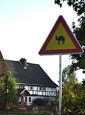
From 1973 to 2012 the winter quarters of the Circus Barum were on Braunschweiger Straße (L487). The impressive courtyard was lavishly prepared for animal husbandry and circus material by the predator tamer and circus director Gerd Siemoneit-Barum . The farm has been owned by the Charles Knie circus since January 2013 .
politics
Volksen forms a joint local council with Negenborn .
The local mayor is Matthias Cohrs (WG).
Culture and sights
The Marienkapelle in Volksen is one of the few surviving medieval village churches in southern Lower Saxony . The approximately 12 meter high defense tower made of quarry stone masonry with loopholes was built first; he had an entrance three meters above the ground. The small Gothic chapel with cross vaults and head consoles was added later. The Marienkapelle is mentioned as a branch church in 1386 , when Florinus de Hupeden was a joint pastor with the parish church of St. Laurentius in Negenborn. The chapel was a place of pilgrimage to the "Pieta von Volksen", a wood-carved Madonna from around 1400 with the body of Jesus on her lap. After the Reformation it was stored in the attic and is now on loan from the Einbeck City Museum . The chapel has remained almost unchanged, the tower can only be climbed via a ladder inside and the bell hanging on the outside is rung by hand on a rope. Today it is used, among other things, as a cemetery chapel.
literature
- Helga Wagner: The Chapel to Volksen . A contribution to their history. Wuerzburg 2014.
- Helga Wagner: The changes in the agricultural landscape in the middle Leinetal from 1750 to 1880 . A case study from southern Lower Saxony (Volksen, Negenborn) on historical economic geography. Issue 84.Würzburg Geographical Manuscripts, Würzburg 2016.
Individual evidence
- ↑ Stadt Einbeck: ( page no longer available , search in web archives ) [PDF; 38 kB]. Retrieved March 22, 2011.
- ↑ coat of arms
- ^ Federal Statistical Office (ed.): Historical municipality directory for the Federal Republic of Germany. Name, border and key number changes in municipalities, counties and administrative districts from May 27, 1970 to December 31, 1982 . W. Kohlhammer, Stuttgart / Mainz 1983, ISBN 3-17-003263-1 , p. 207 .
- ^ Local council Negenborn / Volksen [PDF].
- ↑ Dagmar Koch: Leave the Church in the Village ( Memento from March 26, 2014 in the Internet Archive ) [PDF] in the parish letter of the Evangelical Lutheran parishes of the city of Einbeck from April 14 to 9. June 2013.


