West Chicago
| West Chicago | ||
|---|---|---|
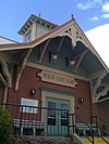
![Turner Town Hall in West Chicago, listed in the NRHP since 1991 [1]](https://upload.wikimedia.org/wikipedia/commons/thumb/9/98/TurnerTownHall.JPG/250px-TurnerTownHall.JPG) Turner Town Hall in West Chicago, listed on the NRHP since 1991 |
||
| Location in Illinois | ||
|
|
||
| Basic data | ||
| Foundation : | 1873 | |
| State : | United States | |
| State : | Illinois | |
| County : | DuPage County | |
| Coordinates : | 41 ° 53 ′ N , 88 ° 13 ′ W | |
| Time zone : | Central ( UTC − 6 / −5 ) | |
| Residents : | 27,086 (as of 2010) | |
| Population density : | 756.6 inhabitants per km 2 | |
| Area : | 35.8 km 2 (approx. 14 mi 2 ) of which 35.8 km 2 (approx. 14 mi 2 ) is land |
|
| Height : | 239 m | |
| Postal code : | 60185 | |
| Area code : | +1 630 331 | |
| FIPS : | 17-80060 | |
| GNIS ID : | 422146 | |
| Website : | www.westchicago.org | |
| Mayor : | Michael B. Kwasman | |
West Chicago is a city (with the status "City" ) in DuPage County in the northeast of the US -amerikanischen state of Illinois . At the 2010 census , West Chicago had a population of 27,086.
West Chicago does not belong to the city of Chicago , but is part of the Chicago metropolitan area .
geography
West Chicago lies at 41 ° 53'18 "north latitude and 88 ° 12'35" west longitude and extends over 35.8 km², which consists only of land.
West Chicago is 35 miles west of downtown Chicago and Lake Michigan .
Neighboring places of West Chicago are Winfield (6 km southeast), Warrenville (10.9 km south), Batavia (11.4 km southwest), Geneva (8.8 km west), St. Charles (11.2 km northwest) , Wayne (10.3 km northwest), Bartlett (15.7 km north), and Carol Stream (8.4 km northeast).
history
The town's previous name was Turner Junction , named after John B. Turner , President of the Galena and Chicago Union Railroad and founder of the town. The name comes from the first railroad crossing in Illinois.
In 1896 the place was renamed West Chicago .
Demographic data
According to the 2010 census , West Chicago had 27,086 people in 7,609 households. The population density was 756.6 inhabitants per square kilometer.
The racial the population was composed of 67.6 percent white, 2.5 percent African American, 0.6 percent Native American, 5.9 percent Asian and other ethnic groups; 2.7 percent were descended from two or more races. Regardless of ethnicity, 51.1 percent of the population was Hispanic or Latino of any race.
Statistically, 3.39 people lived in each of the 7,609 households.
32.4 percent of the population were under 18 years old, 61.4 percent were between 18 and 64 and 6.2 percent were 65 years or older. 48.6 percent of the population was female.
The median income for a household was 64,795 USD . The per capita income was $ 24,498. 10.9 percent of the population lived below the poverty line.
traffic

West Chicago is a junction of various railway lines on the Union Pacific Railroad . West Chicago is also connected to the METRA network, the high-speed rail network in the greater Chicago area.
The Illinois State Routes 38 , 59 and 64 run through the urban area, some of which are motorway-like.
To the west of the city is DuPage Airport , which, in addition to regional air traffic, also serves as a relief and alternative airport for the major airports O'Hare International and Chicago Midway International .
Town twinning
A partnership with the German municipality of Taufkirchen (Vils) in Bavaria has existed since 1999 .
Individual evidence
- ↑ Extract from the National Register of Historic Places - No. 91000573. Retrieved February 20, 2011
- ↑ a b U.S. Census Bureau, State & County QuickFacts - West Chicago, IL ( Memento of the original from February 22, 2014 in the Internet Archive ) Info: The archive link was automatically inserted and not yet checked. Please check the original and archive link according to the instructions and then remove this notice. Retrieved February 20, 2011
- ↑ Distance information according to Google Maps. Accessed on February 20, 2012
