
Wrisberg woods
|
Wrisberg woods
Sibbesse parish
|
||
|---|---|---|
 |
||
| Height : | 196 m above sea level NHN | |
| Area : | 5.27 km² | |
| Residents : | 371 (Aug 18, 2014) | |
| Population density : | 70 inhabitants / km² | |
| Incorporation : | March 1, 1974 | |
| Incorporated into: | West field | |
| Postal code : | 31079 | |
| Area code : | 05065 | |
Location of Wrisbergholzen in Lower Saxony |
||
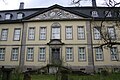
 View of Wrisbergholzen
|
||

Wrisbergholzen is a district of the municipality of Sibbesse in the Hildesheim district in Lower Saxony .
Geographical location
Wrisbergholzen is located south of Hildesheim between the Weserbergland Schaumburg-Hameln and Harz nature parks . It is located between the mountain ranges of Hildesheimer Wald (north) and Vorberge (southwest) with the Seven Mountains on the other side . The village is traversed by the small Alme tributary Holzener Bach. Nearby localities are Westfeld in the north, Segeste in the east-northeast, Almstedt in the east and Grafelde in the southeast.
history
Wrisbergholzen was first mentioned in 1019 as Thiderikes Holzhusen . The Hildesheim bishop Godehard valued the place and visited it frequently, even shortly before his death in 1038. Dietrichholtensen was still used as a place name in the 16th century.
In Wrisbergholzen consisted, according to a first map from 1589, a medieval castle whose origin begins already at the first mention of the Lords of Wrisberg is likely to 1350th The map shows the building with the gate tower in front and the surrounding, water-filled moat . It is a stone-built Renaissance-style building with two storeys and two wings. This was a predecessor facility at the site of Wrisbergholzen Castle, completed in 1745 .
The faience factory Wrisbergholzen , built in 1736, is located on the street “Am Schlosspark”. It is the oldest factory building for faience products in Northern Germany , still preserved in its original design . With the establishment of the factory and the construction of the castle from 1740, more and more craftsmen settled in the village and new houses were built. The manufactory, which has been producing for almost 100 years, contributed to the town's economic prosperity. In 1809 there were around 470 inhabitants, in 1925 there were around 410. At around 40 percent, the majority of the local residents, including many day laborers , worked on the estate. In 1870 the Wrisbergholzen district split into two communities due to disputes over community charges. The estate community and the village community were reunited in 1928.
Manor and castle

The development of the place is closely linked to the existence of the manor , which was in the hands of the Wrisberg family. The family is first documented with Hermann Wristberg on June 5, 1355. At first it was barons who were raised to the rank of count in 1817 . To distinguish the place name from many other "Holthusen" and "Holzen", the aristocratic name Wrisberg became the first part of the place name in the early modern period . In 1920 the estate included around 1,500 hectares of land, of which, according to the Imperial Settlement Act, around 150 hectares had to be made available for settlement purposes as part of the internal colonization .
Today's manor complex with Wrisbergholzen Castle was built between 1740 and 1745. The builder was Count Johann Rudolf von Wrisberg (1677–1764), then President of the Celle Higher Appeal Court . The castle and park are still impressive today, but have been in need of renovation for decades. The old castle park is under nature protection. In the castle there is the tile room as a room tiled with blue and white emblem tiles. The tiles come from the faience factory Wrisbergholzen, which was established in 1736.
Castle Park
The castle initially had two Giardino segreto on today's courtyard side . The baroque main garden extended eastward along the central axis of the palace building. It was a ground floor designed mainly according to French models , which was about the width of today's central building and was of high regularity. The middle of the ground floor, which was separated from the castle by a graft , formed a fountain or a circular square, which was adorned by the stone figure or a vase. A narrow bridge created the connection between the palace and the garden.
The approximately nine hectare park area east of the castle is the result of a redesign in the middle of the 19th century, when Count Werner lived in Wrisbergholzen. He had the romantic staffage erected, which as “monument”, “tea temple” and “water falls” created special points of view and partly served as vantage points into the surrounding landscape. The now overgrown park conveys little of the gardening art of the 19th century. The upper and lower ponds (with “Annettens Insel”) hardly give any indication that these were landscaped scenes. The park was placed under nature protection as the Alter Schlosspark Wrisbergholzen in 1984 , which has not stopped its decline.
20th century
In 1901 Werner Graf Görtz-Wrisberg had a new brick factory built on the outskirts , which replaced an old hand brick factory . 22 employees produce up to a million bricks, roof tiles and pipes every year. In 1903 the village, coming from Alfeld , received the first telephone connection that led to the estate and the brickworks. On the Kirchkamp above the village, the Counts von Wrisberg's family built the Marienstift in 1903 , where sick and frail farm workers were taken in. From 1904 the count had the estate illuminated with gas light . For this purpose, a gas station for the production of aerogen gas was built. In 1911 the village and estate received electricity from the Gronau electricity company. In 1911 a new school building was built in the village.
About one kilometer southwest of the village, on the Wernershöhe (329 m) elevation, there is a building built in 1670 as a hunting lodge , which was owned by Count Görtz-Wrisberg for a long time. In 1906 it was destroyed by a fire and then rebuilt as a residential building for the Vorwerk there . A restaurant with a coffee garden was also built there. After the seizure of power , the National Socialist Motor Corps set up a school in the building in 1938. The Kulturherberge Wernershöhe event center has been located on the site since November 1997 . In 1941, a military field airfield was set up in the vicinity of the Wernershöhe . The Wrisbergholzen Castle was used by the military as a photo site for aerial photographs, while the castle owners were relocated.
Towards the end of the Second World War , American troops shelled the place with artillery and machine guns on April 7, 1945, as they suspected German troops there. The German flying unit from the Wernershöhe had already withdrawn to Hildesheim. As a result of the attack, a cowshed on the estate burned down. In October 1945 British troops quartered in the castle. When they left in January 1946, they took equipment and other inventory with them. After the war, numerous aristocratic families who had left their homeland in the east of the German Empire as expellees chose Wrisbergholzen as their new place of residence. They were initially housed in the castle.
Incorporations
On March 1, 1974, Wrisbergholzen was incorporated into the Westfeld community , which merged with the other member communities of the Sibbesse joint community to form the Sibbesse community on November 1, 2016 .
Until the regional reform in 1977, the region belonged to the Alfeld (Leine) district .
Population development
| year | 1910 | 1925 | 1933 | 1939 | 1950 | 1973 |
|---|---|---|---|---|---|---|
| Residents | 516 ¹ | 417 | 428 | 402 | 842 | 453 |
| source |
¹ including manor district Wrisbergholzen (= 80 inhabitants)
politics
Local councilor and local mayor
Wrisbergholzen is represented at the municipal level by the Westfeld local council .
coat of arms
The design of the municipal coat of arms of the formerly independent municipality of Wrisbergholzen comes from the heraldist and coat of arms painter Gustav Völker , who designed all coats of arms in the Hanover region . The municipality was awarded the local coat of arms on August 10, 1938 by the President of the Province of Hanover . The district administrator from Alfeld handed it over on November 29 of the same year.
|
|
Blazon : "In silver, a green diagonal right-hand bar , covered with three silver shields ." |
| Foundation of the coat of arms: In the early Middle Ages, from the 10th to the 13th century, the ancient noble family "de Holthusen" lived in Wrisbergholzen and were wealthy. Members of this House often stand up to us as witnesses in important legal acts, and often their cooperation is attested by pressing the seal. Due to the coat of arms documented in it, that of the village of Wrisbergholzen has been redesigned. |
Culture and sights
Buildings
- Wrisbergholzen Castle with manor, built from 1740 to 1745 with the tile room from 1752, the walls of which are completely covered with around 800 motto tiles in Italian, French and Latin.
- Former faience manufactory Wrisbergholzen , built in 1736 as "Porcellain Fabrique".
- Ev. St. Martin Church (Wrisbergholzen). The originally early Romanesque church has through its St. Martin - patronage in the time of the Frankish Saxony return mission. It has a remarkable baroque interior and decoration. The west tower from around 1200 has two meter thick quarry stone walls in the lower part, which indicates that it was built as a medieval fortified church . Inside, a wooden pulpit from 1612, a baptismal font from the end of the 16th century, a retable from the middle of the 18th century and the altar from around 1700 are noteworthy.
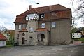
- The rectory opposite the church was built in 1603 (western part) and expanded in 1728 (eastern part).
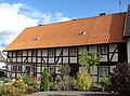
- In the main street of Wrisbergholzen, whose closed development is unusual for a place the size of Wrisbergholzen, several well-preserved half-timbered houses decorated with carvings and wall paintings are worth seeing.
Photo gallery
Entrance area of Wrisbergholzen Castle
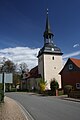
St. Martin Church

The interior of St. Martin
Former school, now used as a village community center
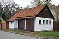
Former fire department store

Rectory from 1603
Houses in the street market

Half-timbered house in Moppenstrasse

Half-timbered house on the square

Row of houses in Poststrasse


Personalities
Sons and daughters of the place
- Karl Guden (1833–1912), General Superintendent in Göttingen, born in Wrisbergholzen
- Ingo Herzke (* 1966), literary translator, grew up in Wrisbergholzen
literature
- Max Grohmann's experiences in Wrisbergholzen. (Estate manager and manager from 1901 at Gut Wrisbergholzen), October 18, 1952, In: Directory of documents from the archives of Count von Goertz-Wrisberg zu Wrisbergholzen. Hildesheim 1953.
- Kulturvereinigung Wrisbergholzen (Hrsg.): Wrisbergholzen Pictures - as it used to be. Horbach am Neckar 1986, ISBN 3-89264-003-3 .
- Heinz-Joachim Tute: Historical gardens in the Hildesheim district. In: Yearbook 1996 of the district of Hildesheim. Pp. 148-149.
Web links
- Website of the municipality of Sibbesse
- Description of architectural monuments in Wrisbergholzen in: Art monuments of the province of Hanover
- Association for the preservation of architectural monuments in Wrisbergholzen
- Cultural Association Wrisbergholzen e. V.
Individual evidence
- ^ So in the Braunschweig-Wolfenbütteler Kirchenordnung of 1569, p. 246 .
- ^ Federal Statistical Office (ed.): Historical municipality directory for the Federal Republic of Germany. Name, border and key number changes in municipalities, counties and administrative districts from May 27, 1970 to December 31, 1982 . W. Kohlhammer, Stuttgart / Mainz 1983, ISBN 3-17-003263-1 , p. 204 .
- ↑ Lower Saxony State Chancellery (ed.): Law on the reorganization of the community Sibbesse, district Hildesheim . Lower Saxony Law and Ordinance Gazette (Nds. GVBl.). No. 19/2015 . Hanover November 12, 2015, p. 304 ( digital version [PDF; 464 kB ; accessed on July 9, 2019] p. 6).
- ↑ Local reorganization. In: Website of the municipality of Sibbesse. Retrieved May 14, 2019 .
- ^ Ulrich Schubert: Register of local authorities in Germany 1900 - Alfeld district. Information from December 1, 1910. In: gemeindeververzeichnis.de. February 3, 2019, accessed November 9, 2019 .
- ^ A b c Michael Rademacher: German administrative history from the unification of the empire in 1871 to the reunification in 1990. Alfeld district ( see under: No. 77 ). (Online material for the dissertation, Osnabrück 2006).
- ^ Federal Statistical Office (ed.): Official municipality directory for the Federal Republic of Germany . Final results according to the September 13, 1950 census. Volume 33 . W. Kohlhammer Verlag, Stuttgart / Cologne August 1952, p. 33 , col. 2 ( digital version [PDF; 26.4 MB ; accessed on November 9, 2019] Alfeld district, p. 42).
- ↑ Lower Saxony State Administration Office (ed.): Municipal directory for Lower Saxony . Municipalities and municipality-free areas. Self-published, Hanover January 1, 1973, p. 29 ( digital version [PDF; 21.3 MB ; accessed on November 9, 2019] District Alfeld (Leine)).
- ↑ District of Hanover (ed.): Wappenbuch district of Hanover . Self-published, Hanover 1985.
- ^ A b Wilhelm Barner : Coat of arms and seal of the Alfeld district . Rebinding. Lax GmbH & Co. KG, Hildesheim 1998 ( digitized version of the text part of the first edition from 1940 [PDF; 10.0 MB ; accessed on June 11, 2019]).
- ^ Georg Dehio : Handbook of German Art Monuments. Bremen, Lower Saxony . Ed .: Dehio Association. Deutscher Kunstverlag, Munich / Berlin 1992, ISBN 3-422-03022-0 , p. 1416 .

Adenstedt | Almstedt | Boar woods | Grafelde | Honze | Möllensen | Sneak | Segeste | Sellenstedt | Sibbesse (Kernort) | Westfield | Wrisberg woods