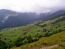
Zázrivá
| Zázrivá | ||
|---|---|---|
| coat of arms | map | |

|
|
|
| Basic data | ||
| State : | Slovakia | |
| Kraj : | Žilinský kraj | |
| Okres : | Dolny Kubin | |
| Region : | Orava | |
| Area : | 67.25 km² | |
| Residents : | 2,615 (Dec. 31, 2019) | |
| Population density : | 39 inhabitants per km² | |
| Height : | 600 m nm | |
| Postal code : | 028 05 | |
| Telephone code : | 0 44 | |
| Geographic location : | 49 ° 17 ′ N , 19 ° 9 ′ E | |
| License plate : | DK | |
| Kód obce : | 510211 | |
| structure | ||
| Community type : | local community | |
| Structure of the municipality: | 11 parts of the community | |
| Administration (as of November 2018) | ||
| Mayor : | Matúš Mních | |
| Address: | Obecný úrad Zázrivá Stred 409 02805 Zázrivá |
|
| Website: | www.zazriva.com | |
| Statistics information on statistics.sk | ||
Zázrivá (Hungarian Zázriva ) is a municipality in northern Slovakia . It is located in the valley of the Zázrivka brook in the Kysucká vrchovina mountains at the foot of the Little Fatra , about 20 km from Dolný Kubín and 35 km from Žilina .
The place was first mentioned in writing in 1555 and emerged from a Wallachian logging settlement . Due to the division into many small hamlets, the municipality is divided into the main town ("Zázrivá-Stred") in the settlements Biela , Demkovská , Dolina , Grúne , Havrania , Končitá , Kozinská , Petrová , Plešivá and Ráztoky .

