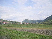
Dlhá nad Oravou
| Dlhá nad Oravou | ||
|---|---|---|
| coat of arms | map | |

|
|
|
| Basic data | ||
| State : | Slovakia | |
| Kraj : | Žilinský kraj | |
| Okres : | Dolny Kubin | |
| Region : | Orava | |
| Area : | 24.311 km² | |
| Residents : | 1,438 (Dec. 31, 2019) | |
| Population density : | 59 inhabitants per km² | |
| Height : | 527 m nm | |
| Postal code : | 027 55 | |
| Telephone code : | 0 44 | |
| Geographic location : | 49 ° 16 ' N , 19 ° 27' E | |
| License plate : | DK | |
| Kód obce : | 509639 | |
| structure | ||
| Community type : | local community | |
| Administration (as of November 2018) | ||
| Mayor : | Ján Kamas | |
| Address: | Obecný úrad Dlhá nad Oravou č. 250 027 55 Dlhá nad Oravou |
|
| Website: | www.dlha.sk | |
| Statistics information on statistics.sk | ||
Dlhá nad Oravou ( Slovak until 1927 Dlhá or Dluhá ; Hungarian Dluha ) is a municipality in the north-center of Slovakia with 1438 inhabitants (as of December 31, 2019), in the Okres Dolný Kubín within the Žilinský kraj and at the same time in the traditional landscape Orava lies.
geography
The municipality is located in the Oravská vrchovina mountains at the foot of the Oravská Magura Mountains to the north . In the south the Orava flows past the place. The center of the village lies at an altitude of 527 m nm and is 15 kilometers from Tvrdošín and 17 kilometers from Dolný Kubín .
Neighboring communities are Babín and Podbiel in the north, Krivá in the northeast and east, Chlebnice in the south and Sedliacka Dubová in the west.
history
Dlhá nad Oravou was mentioned in writing for the first time in 1420 as Dluha Luka and was in agreement with the neighboring town of Sedliacka Dubová until the 16th century. The village arose on the territory of the Arwaburg , was administered by hereditary bailiffs and belonged to the Arwaburg until serfdom was abolished in 1848. In 1683 it was devastated by a Polish-Lithuanian army. In 1715 there are 560 inhabitants, in 1828 there were 153 houses and 1,087 inhabitants who were employed in agriculture, livestock farming and trading in burrs . There were also three sawmills, a forge, basket makers and weavers.
The place in Arwa County belonged to the Kingdom of Hungary until 1918 and then became part of Czechoslovakia or now Slovakia. Fires in 1930 and 1962 caused considerable economic damage.
population
According to the 2011 census, Dlhá nad Oravou had 1,379 inhabitants, 1,372 of whom were Slovaks and three Czechs. Four residents made no statement. 1,339 residents committed themselves to the Roman Catholic Church, two residents to the Jehovah's Witnesses and one resident to the Greek Catholic Church; one resident was of a different denomination. Five residents were non-denominational and the denomination of 31 residents has not been determined.
Results after the 2001 census (1364 inhabitants):
|
By ethnicity:
|
By denomination:
|
Buildings
- Roman Catholic Ladislaus Church, originally a baroque-classical chapel from 1811, later expanded
- Path chapels from the 18th and 19th centuries
- wooden granaries along the main road
traffic
The 1st order road 59 ( E 77 ) runs through the village on the way from Ružomberok to the Polish border; a bypass on the R3 expressway is being planned. There is a stop on the Kraľovany – Suchá Hora railway line with several daily local trains.
Individual evidence
- ↑ 2011 census by ethnicity (English)
- ↑ Census 2011 after confession (English) ( Memento of 12 November 2013, Internet Archive )
Web links
- Entry on e-obce.sk (Slovak)


