
Rockall: Difference between revisions
m BOT - rv 137.43.6.247 (talk) to last version by MacRusgail |
|||
| Line 64: | Line 64: | ||
The formal annexation of Rockall was announced by the [[Admiralty]] on [[21 September]] [[1955]]. |
The formal annexation of Rockall was announced by the [[Admiralty]] on [[21 September]] [[1955]]. |
||
[[Image:Rockall.jpg|thumb|200px|Photograph taken by the [[Royal Navy]] in 1974]] |
|||
The initial incentive for the annexation of Rockall had little to do with any territorial claim to rights of exploitation of the seas around the island. It was the test firing of the UK's first guided [[nuclear weapon]], the [[United States|American]]-made [[MGM-5 Corporal |Corporal missile]]. The missile was to be launched from South Uist and over the North Atlantic. The [[Ministry of Defence (United Kingdom)|Ministry of Defence]] was concerned that the unclaimed island would provide a unique opportunity for [[Soviet Union]] to spy on the test by placing surveillance equipment on the island; and so in April of 1955 a request was sent to the Admiralty to seize the island, and declare UK sovereignty lest it become an outpost for foreign observers. |
The initial incentive for the annexation of Rockall had little to do with any territorial claim to rights of exploitation of the seas around the island. It was the test firing of the UK's first guided [[nuclear weapon]], the [[United States|American]]-made [[MGM-5 Corporal |Corporal missile]]. The missile was to be launched from South Uist and over the North Atlantic. The [[Ministry of Defence (United Kingdom)|Ministry of Defence]] was concerned that the unclaimed island would provide a unique opportunity for [[Soviet Union]] to spy on the test by placing surveillance equipment on the island; and so in April of 1955 a request was sent to the Admiralty to seize the island, and declare UK sovereignty lest it become an outpost for foreign observers. |
||
Revision as of 14:00, 11 October 2006

Rockall is a small, rocky islet in the North Atlantic, in the exclusive economic zone (EEZ) of the United Kingdom. It is probably better known as one of the Sea Areas named in the Shipping Forecast broadcast on BBC Radio 4. The United Kingdom's title to Rockall is not contested (or even regarded as relevant) by its neighbours. In 1997, the UK abandoned[1] any claim to an extended EEZ around and beyond it. The remaining issue is that the status of the continental shelf rights of surrounding ocean floor is disputed with the United Kingdom by the Republic of Ireland, Denmark (for the Faroe Islands), and Iceland. These are the exclusive rights to exploit any resources on or under the ocean floor (oil, natural gas, etc.) and should not be confused with the EEZ, as continental shelf rights do not carry any privileges with regard to fisheries.
Name
The origin of the name is debatable but it has been suggested that it derives from the Scottish Gaelic Sgeir Rocail which is often translated as "Roaring Rock" although rocail can also be translated as "tearing" or "ripping". There may also be an etymological link with the old Norse hrukka.
The first literary reference to the isle, where it is called Rockol, is found in Martin Martin's A Description of the Western isles of Scotland published in 1716 where he gives an account of a voyage to St Kilda where the locals knew the isle as Rockabarra (Rocabarraigh). The name Rocabarraigh is also used in Gaelic folklore for a mythical rock which is supposed to appear three times, the last being at the end of the world.
- “Nuair a thig Rocabarra ris, is dual gun tèid an Saoghal a sgrios”.
- (When Rocabarra returns, the world will likely come to be destroyed/ruined)
Other mythological stories surrounding Rockall:
"Fionn MacCumhaill took a sod of grass and he threw it to the fore, Then he tossed a pebble across the sea, where ever it did fall, For the sod became the Isle of Man and the pebble's called Rockall."
Geography
The rock is the summit of an extinct volcano and is located at 57°35′48″N 13°41′19″W / 57.59667°N 13.68861°W. The surrounding elevated seabed is called Rockall Bank. It is 301.4 kilometres (187.3 statute miles or 162.7 nautical miles) west of the uninhabited island of Soay, St. Kilda, Scotland and 368.7 kilometres (229.1 statute miles) west of the crofting township of Hogha Gearraidh, on the island of North Uist, Scotland. It is 424 kilometres (265 statute miles) north-west of Donegal in the Republic of Ireland. The rock is about 25 metres (83 ft) wide at its base and rises sheer to a height of approximately 22 metres (72 ft). It is regularly washed over by large storm waves, particularly in winter. There is a small ledge of 3.5 by 1.3 metres (11 by 4 ft), known as Hall's Ledge, 4 metres (13 ft) from the summit. The rock's only permanent inhabitants are periwinkles and other marine molluscs. Small numbers of seabirds, mainly fulmars, gannets, kittiwakes, and guillemots, use the rock for resting in summer, and gannets and guillemots occasionally breed successfully if the summer is calm with no storm waves washing over the rock. There is no natural source of fresh water.
Rockall is also close to the Darwin Mounds, deep-water coral mounds about 185 km (100 nm or 115 mi) north-west of Cape Wrath.
Geological surveys

The exact position of Rockall and the size and shape of the Rockall Bank was first charted in 1831 by Captain A.T.E. Vidal, a Royal Navy surveyor.
The first scientific expedition to Rockall was led by Miller Christie in 1896 when the Royal Irish Academy sponsored a study of the flora and fauna [5] They chartered the Granuaile [6]
The RV Celtic Explorer has surveyed the Rockall Bank and North West of Donegal in 2003.[2]
The ILV Granuaile was chartered by the Geological Survey of Ireland (GSI), on behalf of the Department of Communications, Marine & Natural Resources (DCMNR), to conduct a seismic survey at the Rockall and Hatton Banks in July 2004.[3]The seismic survey was part of the National Seabed Survey which has been ongoing for 4 years.[4]
There has been one amateur radio visit to Rockall, in 2005, and the following year a second was planned. Unfortunately the high cost of this visit led to its cancellation.
Disasters
There have been disasters on the neighbouring Hasselwood Rock and Helen's Reef (Helen's Reef was not named until 1830)
- 1686 — a Spanish merchant ship, bound for the New World ‘ran on the rocks’ on 22 August 1686; 250 people lost their lives.
- 1812 — survey vessel Leonidas foundered on Helen's Reef
- 1824 — brigantine Helen of Dundee, bound for Quebec, foundered at Hasselwood Rock; "the crew left most of the passengers to drown, including seven women and six children".
- 1904 — SS Norge, 3,318 tons with 700 emigrants from Copenhagen to New York on 28 June 1904; 635 lost
- 1984 — Jack (John) Lavelle was lost overboard from the yacht Helen, while returning from Rockall. [7]
There have also been reports in national newspapers in both the Republic of Ireland and the United Kingdom that at least two unexploded bombs from World War II lie within a 250-metre radius of Rockall. At present, no attempts have been made to remove them.
Law of the Sea
The United Nations Convention on the Law of the Sea, states “Rocks which cannot sustain human habitation or economic life of their own shall have no exclusive economic zone or continental shelf.” The Republic of Ireland, Denmark, and Iceland all acceded to the convention. The United Kingdom acceded to the convention on 25 July 1997. The United Kingdom and the Republic of Ireland have agreed to a delineation which ignores Rockall's existence and have granted exploration rights.
History and conflicting claims
The United Kingdom's claims to the island
Rockall is 461.5 km (286.7 miles) from Ardnamurchan Point (approximately WGS84 Latitude North 56 Degrees 43 Minutes 38.3 Seconds, Longitude West 6 Degrees 13 Minutes 38.1 Seconds), the nearest point on the Scottish mainland; and 301.4 km (187.3 miles) from the St Kilda archipelago (approximately WGS84 Latitude North 57 Degrees 49 Minutes 40.8 Seconds, Longitude West 8 Degrees 38 Minutes 59.7 Seconds), the nearest (undisputed) Scottish islands, which are 53 miles west of the Isle of Harris in the Outer Hebrides. Also, Rockall is 367.0 km (228.0 statute miles) (198.1 nautical miles) from Aird an Runair on the island of North Uist (approximately WGS84 Latitude North 57 Degrees 36 Minutes 9.7 Seconds, Longitude West 7 Degrees 32 Minutes 56.4 Seconds), Outer Hebrides, the nearest inhabited island of Scotland after St Kilda was evacuated in 1930.
In 1997 the United Kingdom ratified the 1982 United Nations Convention on the Law of the Sea. In doing so it relinquished its right to claim an exclusive economic zone (EEZ) of 200 nautical miles (370 km) extending from the rock, as the agreement states that "Rocks which cannot sustain human habitation or economic life of their own shall have no exclusive economic zone or continental shelf". However, as Rockall lies within 200 nautical miles (370 km) of both St Kilda and North Uist, the island itself remains within the EEZ of the United Kingdom and as such, under international law the UK can claim "..the sovereignty of the coastal state in relation to the exploitation, conservation and management of natural and living resources fishery and mineral resources" of the rock itself and an area of territorial waters extending for 12 nautical miles around it. Furthermore, the United Kingdom and the Republic of Ireland have signed a boundary agreement which includes Rockall in the United Kingdom area.
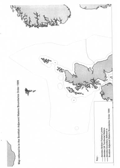
Rockall, and a large sea area around it, was confirmed as coming under the jurisdiction of Scots law under the Scottish Adjacent Waters Boundaries Order (map) in 1999.
The earliest recorded landing on the island was on 8 July 1810 when a Royal Navy officer called Basil Hall led a small landing party from the frigate HMS Endymion to the summit. The frigate was taking depth measurements around Rockall when it drifted away in a haze. The expedition made a brief attempt to find the frigate in the haze, but soon gave up and returned to Rockall. After the haze became a fog, the lookout sent to the top of Rockall spotted the ship again, but it turned away from Rockall before the expedition in their boats reached it. Finally, just before sunset, the frigate was again spotted from the top of Rockall, and the expedition was able to get back on board. The crew of the Endymion reported that they had been searching for five or six hours, firing their cannons every ten minutes. Hall related this experience and other adventures in a book entitled Fragment of Voyages and Travels Including Anecdotes of a Naval Life.
The next landing was accomplished by a Mr Johns of HMS Porcupine, whilst the ship was on a mission, from June and August of 1862, to make a survey of the sea bed prior to the laying of a transatlantic cable. Johns managed to gain foothold on the island, but failed to reach the summit.
On 18 September 1955 at precisely 10.16 am, in what would be the final territorial expansion of the British Empire, the island was officially annexed by the UK when Lieutenant-Commander Desmond Scott RN, Sergeant Brian Peel RM, Corporal AA Fraser RM, and James Fisher (a civilian naturalist and former Royal Marine), were deposited on the island by a Royal Navy helicopter from HMS Vidal (coincidentally named after the man who first charted the island). The team cemented in a brass plaque on Hall's Ledge and hoisted the Union Flag to stake the UK's claim.
The inscription on the plaque reads:
- "By authority of Her Majesty Queen Elizabeth II, by the Grace of God of the United Kingdom of Great Britain and Northern Ireland and of her other realms and territories Queen, Head of the Commonwealth, Defender of the Faith, and in accordance with Her Majesty's instructions dated the 14th day of September, 1955, a landing was effected this day upon this island of Rockall from HMS Vidal. The Union flag was hoisted and possession of the island was taken in the name of Her Majesty. [Signed] R H Connell, Captain, HMS Vidal, 18 September 1955."
The formal annexation of Rockall was announced by the Admiralty on 21 September 1955.
The initial incentive for the annexation of Rockall had little to do with any territorial claim to rights of exploitation of the seas around the island. It was the test firing of the UK's first guided nuclear weapon, the American-made Corporal missile. The missile was to be launched from South Uist and over the North Atlantic. The Ministry of Defence was concerned that the unclaimed island would provide a unique opportunity for Soviet Union to spy on the test by placing surveillance equipment on the island; and so in April of 1955 a request was sent to the Admiralty to seize the island, and declare UK sovereignty lest it become an outpost for foreign observers.
On 10 February 1972 the Isle of Rockall Act received Royal Assent to make the island administratively part of the Isle of Harris (St Kilda being administratively part of Harris), in what was then Inverness-shire, fully incorporating it into the United Kingdom. A navigational beacon was later installed on the island and the UK declared that no ship would be allowed within a 50-mile radius of the rock. In United Kingdom law, it now falls administratively under the Outer Hebrides.
Former SAS member and survival expert Tom McLean lived on the island from 26 May 1985 to 4 July 1985 to affirm the UK's claim to the island.[8]
Irish claims to areas around Rockall
The Republic of Ireland does not have formal claim to Rockall, regarding it as merely an uninhabitable rock without any territorial waters and thus irrelevant when determining the boundaries of the exclusive economic zones of Denmark, the Republic of Ireland, Iceland, and the United Kingdom. More populist claims to the island are based, in part, on the fact that Rockall is 424 kilometres (265 miles) from Donegal in the Republic of Ireland.[5]
According to a Written Parliamentary Answer from the Irish Minister of Foreign Affairs on June 14 1990, an agreement was reached between the British and Irish governments on delimitation of the continental shelf between the two countries and that this included a line of delimitation across the Rockall Plateau. As a result, a very extensive area under Irish jurisdiction, including part of the Rockall Trough and Plateau, is undisputed by the United Kingdom. Ownership of Rockall itself, and the area surrounding it, did not form part of that agreement and was not affected by it. No further negotiations were taking place in relation to the rock at the time.
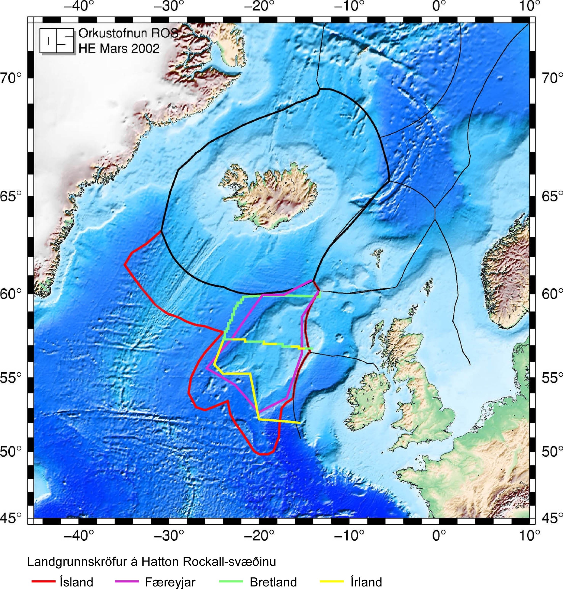
More recently, on June 11 2003, the Irish Minister for Communications, Marine and Natural Resources gave a Written Parliamentary Answer, stating: "Ireland claims an extended continental shelf … up to more than 500 nautical miles (926 km), particularly in the Hatton–Rockall area." As the United Nations Commission on the Limits of the Continental Shelf has no mandate regarding issues of delimitation between neighbouring states and cannot consider an area under dispute without the agreement of all the parties concerned, the Republic of Ireland has participated in informal discussions with Iceland and the Faroe Islands in an attempt to resolve the dispute before making its submission to the Commission, which it hopes to make by 2006.
Populist claims
Independent Irish politician Seán Dublin Bay Rockall Loftus (1927–), a former Lord Mayor of Dublin (1995–1996), has long advocated that the Republic of Ireland make a territorial claim on Rockall, and enthusiastically supported Greenpeace's occupation. He changed his name by deed poll twice: adding "Rockall" to demonstrate his commitment to that cause, and "Dublin Bay" to show his support for the protection of Dublin's environment. The Wolfe Tones, an Irish rebel music band, released a song Rock on Rockall that supports an Irish claim (lyrics).
Icelandic claims in the area
Iceland does not claim the rock itself, considering it irrelevant as far as delimination of EEZs and continental shelf is concerned. Iceland however claims an extended continental shelf in the Hatton-Rockall area.
Iceland ratified UNCLOS in 1985; it was the first Western country to do so. A regulation was issued by the government in that same year outlining the area where Iceland claimed continental shelf rights for itself; the regulation was based on legislation from 1979 claiming for Iceland the exclusive right to research and exploitation of continental shelf-based resources within the limits of the Icelandic continental shelf. Regarding the Hatton-Rockall area, it claims the area within 60 nautical miles from the foot of the continental shelf and assumes that the UK and the Republic of Ireland can not claim a continental shelf outside their EEZs. To its fullest extent, this area reaches about 700 nautical miles to the south from Iceland's coast, which is further south than the United Kingdom's southernmost point.
In 2001, Iceland began working on its submission to the Commission on the Limits of the Continental Shelf; it is scheduled to finish in 2007. The most important aspect of this work is to survey the entire ocean floor in the areas claimed outside the EEZ and, in Iceland's case, a part of the area inside the EEZ as well. In all, 1.3 million square kilometres have been surveyed by Icelandic marine research institutions for this purpose, an area 13 times larger than the land area of Iceland. The commission does however not make proposals regarding areas that are claimed by two or more states unless they have already reached an agreement on its division. Therefore Iceland's submission is expected to deal only with the area that just Iceland has claimed and not the Hatton-Rockall area. Iceland also hosted an informal meeting of all parties to the dispute in 2001. It was the first such meeting regarding the dispute where all four countries participated.
Danish/Faroese claims in the area
The Faroe Islands are an autonomous region of the Kingdom of Denmark. Since 1948 they have had self-government in almost all matters except defence and foreign affairs. Consequently their interests in Rockall are represented by Denmark. On their behalf, Denmark claims continental shelf rights in the Hatton Rockall area. It does not claim the islet itself — their position is the same as is the Republic of Ireland's and Iceland's.
Waveland and the Greenpeace occupation
In 1997 the environmentalist organisation Greenpeace occupied the islet for a short time, calling it Waveland, to protest against oil exploration under the authority of the British. Greenpeace declared the island to be a “new Global State”, and offered citizenship to anyone willing to take their pledge of allegiance. The British Government's response was simply to give them permission to be there, and otherwise ignore them. Indeed the Home Office when asked, responded that since Rockall was part of the United Kingdom, and since the UK was a free country, Greenpeace were perfectly entitled to be at Rockall.
The project continued until 1999, when the company sponsoring it collapsed and the experiment ended. This interlude nevertheless marked the longest continuous habitation of the islet, at forty-two days.
Rockall in literature and culture
- After the 1955 UK annexation, David Frost on BBC satirical show That Was The Week That Was coined the phrase "Sweet Rockall".[6]
- The Rockall dispute was explored in an episode of the BBC drama Ambassador, which starred Pauline Collins as British ambassador to the Republic of Ireland.
- Rockall is the setting for William Golding's 1956 novel Pincher Martin, a surreal, nightmarish vision of one man's battle for physical and (more tellingly) mental survival in the most unforgiving and hostile of environments. The rock itself becomes the central motif of the novel and symbolises the main character's postmodernist alienation from the "real" world.
- One of Irish/Celtic band The House Band's albums is entitled Rockall.
- The Icelandic jazz-funk band Mezzoforte recorded an instrumental track called 'Rockall', used as the background music for the BBC Radio 1 pop chart countdown in the 1980s.
- The lyrics of the song Ether by English band Gang of Four proclaim: "There may be oil, under Rockall" [9].
- Rock On Rockall by Brian Warfield (The Wolfe Tones)
- Rockall is also the name of the land where Anthony Swithin's fantasy series The Perilous Quest for Lyonesse takes place.
- The conclusion of the episode Napoleon's Piano from the 1950s BBC Radio series The Goon Show is claimed by one of the characters, Bluebottle, to take place on Rockall. He is lowered from "a recording of a helicopter" to plant then salute the Union Flag on the islet and claim it for the United Kingdom. A few moments later the sound effect of an incoming rocket ending in an explosion presumably signals its demise.
- The Master, an adventure novel by T. H. White, involves two children who are stranded on Rockall. They find that it is hollow and inhabited by a mysterious person who aims to take over the world.
- Rockall is the home of several of the avian characters in Steve Bell's comic strip If...
- Rockall is the title and setting of a futuristic novel by Ben Emlyn-Jones. The island portrayed is larger than the real one, but lies at the same location. It tells the story of a group of explorers who land on the island and try to build a colony there.
- In his book Attention All Shipping, the author Charlie Connelly travels around all the places mentioned in the shipping forecast. He talks about Rockall but does not manage to visit it.
- After the British annexation of Rockall, Flanders and Swann composed the song Rockall in mock celebration.
- Good Evening, Rockall, was the title of a short-lived news-orientated panel game shown on BBC Choice, hosted by Ed Docx (first series) and Sue Perkins (second series).
- Geheimen van het Noorden (Mysteries from the North), a novel by Jean Ray, mentiones the Rockall as a demonic place and a danger for navigation.
- Storm over Rockall by W. Howard Baker, was a thriller in a series of books starring the character of John Drake.
- At the end of the novel Cruel Sea by Nicholas Monsarrat, HMS Saltash is ordered to accept the surrender of German U-boats at Rockall.
See also
- Okinotorishima, coral reefs in the Pacific Ocean, claimed by Japan as an island and thus sovereign territory with territorial waters but regarded by the Peoples Republic of China as being an insignificant and irrelevant rock.
- Senkaku Islands, five small islands currently under Japanese control, but claimed by the People's Republic of China and the Republic of China (Taiwan).
- Rocabarraigh, a phantom island which appears to have been partly conflated with Rockall.
- Imia/Kardak, two small uninhabited islets in the Aegean Sea, which were the object of a dispute over sovereignty between Turkey and Greece in 1996.
- Socotra Rock,a submerged rock in the East China Sea.Korea claimed which the rock is a island.
References
- ^ See section on Law of the Sea
- ^ [1]
- ^ [2]
- ^ Captain Dermot Gray Granuaile carries out seismic survey at Rockall Beam, the Journal of the Irish Lighthouse Service, Vol 33 2004/2005[3]
- ^ "The significant fact is that the island is 300 miles west of Scotland and 250 miles north-west of the coast of Donegal." [4]
- ^ Fraser MacDonald The last outpost of Empire: Rockall and the Cold War Journal of Historical Geography 32 (2006) 627-647
- Fraser MacDonald, 'The last outpost of Empire: Rockall and the Cold War', Journal of Historical Geography, 32 (2006),627-647. available in pdf
- Birds breeding on Rockall. British Birds 86: 16–17, 320–321 (1993).
- Oral Questions to the Minister of Foreign Affairs in the Dáil Éireann, November 1, 1973
- Written Answer from the Minister of Foreign Affairs in the Dáil Éireann, June 14, 1990
- Written Answer from the Minister for Communications, Marine and Natural Resources in the Dáil Éireann, June 11, 2003
External links
- Template:PDFlink Rockall – The most isolated speck of Rock, surrounded by Water on the Surface of the Earth by James A. Macintosh, published 1945. Includes Basil Hall's description of his Rockall landing.
- Icelandic Ministry of Foreign Affairs map showing all parties' claims to the continental shelf around Rockall.
- Waveland site
- The Rockall Times, a surreal news site themed around Rockall.
- British journalist Ben Fogle attempts to claim Rockall
- A Rockall datasheet
- 1955: Britain claims Rockall, On This Day story from BBC website.
- MSØIRC/p radio amateur expedition (16 June 2005)
Inhabited islands of the Hebrides | ||
|---|---|---|
| Inner Hebrides |  | |
| Outer Hebrides | ||