Alby-sur-Chéran
| Alby-sur-Chéran | ||
|---|---|---|

|
|
|
| region | Auvergne-Rhône-Alpes | |
| Department | Haute-Savoie | |
| Arrondissement | Annecy | |
| Canton | Rumilly | |
| Community association | Grand Annecy | |
| Coordinates | 45 ° 49 ′ N , 6 ° 1 ′ E | |
| height | 360-606 m | |
| surface | 6.56 km 2 | |
| Residents | 2,579 (January 1, 2017) | |
| Population density | 393 inhabitants / km 2 | |
| Post Code | 74540 | |
| INSEE code | 74002 | |
| Website | www.mairie-alby-sur-cheran.fr | |
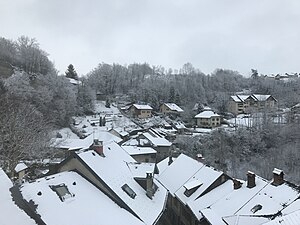
 Alby-sur-Chéran in winter |
||
Alby-sur-Cheran is a French commune in the department of Haute-Savoie in the region of Auvergne Rhône-Alpes . It belongs to the canton of Rumilly in the Arrondissement of Annecy .
geography
Alby-sur-Chéran is located at 399 m , about 13 kilometers southwest of the city of Annecy (beeline). The town extends in the foothills of the Alps at the foot of the Semnoz , in the Albanais , at an old bridge crossing over the Chéran .
The area of the 6.56 km² municipal area includes a section of the Albanais. The central area is occupied by the valley of the Chéran. This flows with several turns in a notched valley sunk into the molasse layers of the area from south to north. To the east of the valley, the communal soil extends to the adjacent plateaus, which are subdivided by the valleys of various side streams of the Chéran. To the west, the municipality extends to the plateau of Chède and reaches the highest point of Alby-sur-Chéran at 606 m on the ridge of Héry-sur-Alby .
In addition to the actual town center, Alby-sur-Chéran has several hamlet settlements and farms, including:
- Le Chêne ( 445 m ) on the plateau east of the valley of the Chéran
- Chède ( 470 m ) on the plateau west of the valley of the Chéran
- Masigny ( 475 m ) west of the Chéran valley
- Beaunoyer ( 500 m ) west of the Chéran valley
Neighboring municipalities of Alby-sur-Chéran are Marigny-Saint-Marcel , Saint-Sylvestre and Chapeiry in the north, Viuz-la-Chiésaz and Mûres in the east, Héry-sur-Alby in the south and Saint-Félix in the west.
history
The municipality of Alby-sur-Chéran was already settled during Roman times, which was proven by the wall foundations near Masigny. In the Middle Ages, Alby was mentioned under the Latinized names Albiacum and Arbiacum . The place name goes back to the Gallo-Roman surname Albius and means something like country estate of Albius . The place name changed over time via Albie to Alby . It was not until 1862 that the now official municipality name Alby-sur-Chéran was introduced.
In the Middle Ages, Alby-sur-Chéran was owned by the Counts of Geneva . Under Count Amadeus II of Geneva, the place was granted certain rights of freedom in 1297. The town was located on an important bridge crossing over the Chéran on the way between Annecy and Chambéry . Alby-sur-Chéran was an important center of leather processing and shoemaking from the 14th to the beginning of the 20th century.
Attractions
Alby-sur-Chéran has retained its character as a medieval market town. In the center is the triangular Place du Trophée, which is surrounded by houses with arcaded arches. Because of several fires, the current structure mostly dates from the middle of the 19th century. The Musée de la Cordonnerie (shoemaker's museum) is housed in the town hall. A stone bridge, which was built in 1720, crosses the Chéran. It was rebuilt in its original state after being destroyed in 1940.
To the west of the village is the Saint-Maurice chapel, which originally dates from the 14th century. The modern parish church of Notre-Dame de Plaimpalais was built from 1953 to 1960 according to plans by the architect Maurice Novarina . To the north of Alby-sur-Chéran is the former Château de Montpon (14th century; later rebuilt several times), the only one of seven mansions that has been preserved.
population
| Population development | |
|---|---|
| year | Residents |
| 1962 | 810 |
| 1968 | 782 |
| 1975 | 799 |
| 1982 | 1.014 |
| 1990 | 1,224 |
| 1999 | 1,630 |
| 2004 | 1,870 |
With 2579 inhabitants (as of January 1, 2017), Alby-sur-Chéran is one of the smaller communities in the Haute-Savoie department. In the course of the 19th and 20th centuries, the population decreased continuously due to strong emigration (in 1881 Alby-sur-Chéran had 1151 inhabitants). Since the mid-1970s, however, thanks to the attractive residential area, there has been a marked increase in population again.
Economy and Infrastructure
Alby-sur-Chéran has always been a market town characterized by trade and the shoemaker's trade. From 1915 to 1984 it was the location of a foundry that employed up to 150 employees. Today the place benefits from the close connection to the motorway. There are numerous small and medium-sized businesses. An industrial zone has developed on the plateau west of Alby-sur-Chéran since the 1970s. Service companies, trading companies and shops settled here. Many workers are commuters who work in the larger towns in the area and in the Annecy area.
The village is very well developed in terms of traffic. It is on the main road N201, which runs from Annecy to Chambéry. Other regional road connections exist with Rumilly and Lescheraines . The closest connection to the A41 motorway , which crosses the municipality and spans the Chéran valley with a high bridge, is around 3 km away.
