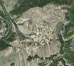
Aleksandrovac (Negotin)
|
Александровац Aleksandrovac Zlocutea |
||||
|
||||
| Basic data | ||||
|---|---|---|---|---|
| State : | Serbia | |||
| Okrug : | boron | |||
| Opština : | Negotin | |||
| Coordinates : | 44 ° 3 ' N , 22 ° 27' E | |||
| Residents : | 570 (2002) | |||
| Telephone code : | (+381) 019 | |||
| Postal code : | 19314 | |||
| License plate : | NG | |||
| Structure and administration (as of 2008) | ||||
| Community type: | Village | |||
| Mayor : | Dušan Mišić | |||
| Postal address : | MK Aleksandrovac 19314 Rajac |
|||
| Others | ||||
| City Festival : | Sveti Ilija | |||
Aleksandrovac [ alɛkˈsandrɔvat͡s ] ( Serbian - Cyrillic Александровац , Romanian : Zlocutea ) is a village in Opština Negotin and in Okrug Bor in eastern Serbia , on the Bulgarian border. It is located about 25 kilometers south of Negotin .
geography
Geographical location
Aleksandrovac is located in the Opština Negotin , one of the easternmost municipalities in Serbia , in the Okrug Bor in central Serbia . The village is located in the northern part of the Timočka Krajina region , and thus at the foot of the Carpathian Mountains .
climate
Aleksandrovac has a temperate continental climate with the four seasons common for Europe .
Nature and water
The Timok River flows through the village, which is located on the right bank, in the northwest.
Village shape
The village is a scattered settlement . Originally houses were built around the central square in the center of the village, but in recent years features of a street village have become apparent.
Close to towns and villages
Aleksandrovac is located in the south of the Negotin municipality, on the Bulgarian border
|
Smedovac 5 km |
Rogljevo 5 km |
Veljkovo 5 km |
|
Rajac 2 km |

|
Kovilovo 3 km |
|
Crnomasnica 4 km |
Bulgaria 2 km |
Bulgaria 4 km |
history
The village is first mentioned by name in Ottoman records in 1491 . At that time, like the rest of the region, it belonged to the Ottoman Empire . It probably had a different, Turkish, name at the time.
From 1878 until the end of the First World War in 1918, the village was under Bulgarian rule and was named Zlokukya (Злокукя).
After that the village was incorporated into the Kingdom of Serbs, Croats and Slovenes . In the interwar period , the village was renamed Aleksandrovac, after the then reigning Serbian King Aleksandar I Karađorđević .
After the Second World War, however, in 1947, the village was renamed Zokušan again. It was not renamed Aleksandrovac until the 1980s. During the Socialist Federal Republic of Yugoslavia , the underground water pipes were laid in 1975, the roads were paved in 1977 and in 1986 Aleksandrovac was connected to the state telephone network.
A new Serbian Orthodox Church is being built in Aleksandrovac, dedicated to the Holy Great Martyr Pantaleon . The church belongs to the Timok Eparchy of the Serbian Orthodox Church.
Residents
In 2002 the village had 570 inhabitants (self-denomination). Most of them were members of the Serbian Orthodox Church.
Of which were:
| number | percent | |
| total | 570 | 100 |
| Wallachians | 283 | 49.64 |
| Serbs | 255 | 44.76 |
| Romanians | 18th | 3.15 |
| Macedonians | 4th | 0.70 |
| Bulgarians | 2 | 0.35 |
| Unknown | 8th | 1.40 |
Other censuses:
| 1921 | 1948 | 1953 | 1961 | 1971 | 1981 | 1991 |
|---|---|---|---|---|---|---|
| 930 | 1,015 | 1,031 | 1,056 | 1,077 | 1,085 | 994 |
swell
References and comments
- ↑ BO will be taken out of service in the course of the year, see also license plate (Serbia)
- ↑ Website of the municipality of Negotin - Mesne Kancelarije ( Memento from September 4, 2012 in the web archive archive.today )
- ↑ Not a mayor in the western sense, rather the chairman of the village authority
- ↑ Information for the water lily as the crow flies
- ↑ Information according to Google Earth
- ↑ Website of the municipality of Negotin ( Memento from September 11, 2012 in the web archive archive.today )


