
Aspangberg-St. Peter
|
Aspangberg-St. Peter
|
||
|---|---|---|
| coat of arms | Austria map | |
 |
|
|
| Basic data | ||
| Country: | Austria | |
| State : | Lower Austria | |
| Political District : | Neunkirchen | |
| License plate : | NK | |
| Main town : | Sonneck | |
| Surface: | 81.7 km² | |
| Coordinates : | 47 ° 33 ' N , 16 ° 1' E | |
| Height : | 490 m above sea level A. | |
| Residents : | 1,855 (January 1, 2020) | |
| Postcodes : | 2870, 2872, 2873 | |
| Area code : | 02642 | |
| Community code : | 3 18 03 | |
| NUTS region | AT122 | |
| Address of the municipal administration: |
Sonneck 4 2870 Aspangberg-St. Peter |
|
| Website: | ||
| politics | ||
| Mayor : | Bernhard Brunner ( ÖVP ) | |
|
Municipal Council : ( 2020 ) (19 members) |
||
| Location of Aspangberg-St. Peter in the Neunkirchen district | ||
  |
||
| Source: Municipal data from Statistics Austria | ||

Aspangberg-St. Peter is a municipality with 1855 inhabitants (as of January 1, 2020) in the Neunkirchen district in Lower Austria .
geography
Aspangberg-St. Peter is located in the industrial district in Lower Austria. The municipal area completely encloses the municipality Aspang-Markt as a central place.
The area of the municipality covers 81.7 square kilometers, about 69% of the area is forested.
Community structure
The municipality is divided into ten localities (population in brackets as of January 1, 2020):
- Outside (137)
- Hoffeld (325)
- Hell (340)
- Internal (130)
- Koenigsberg (138)
- Langegg (203)
- Neustift am Alpenwalde (30)
- Neustift am Hartberg (87)
- Neuwald (452)
- Sonneck (13)
The municipal area comprises four cadastral communities (area as of December 31, 2019):
- Great Office (2,130.45 ha)
- Small Office (2,114.75 ha)
- Neustift am Alpenwald (1,779.60 ha)
- Neuwald (2,123.98 ha)
Neighboring communities
history
In ancient times, the area was part of the Noricum province .
On January 1, 1971, the communities Aspangberg and St. Peter am Wechsel became the community Aspangberg-St. Peter folded.
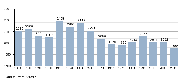
Population development
religion
According to the data of the 2001 census , 90.8% of the population were Roman Catholic , 1.3% Protestant , 1.6% Muslim , 0.2% belonged to Orthodox churches . 4.5% of the population had no religious denomination.
Economy and Infrastructure

In 2001 there were 61 non-agricultural workplaces; according to the 1999 survey, there were 150 agricultural and forestry holdings. According to the 2001 census, the number of people in employment at the place of residence was 918; the 2001 employment rate was 47 percent.
Sports
- In the middle of the municipality there are two small ski areas - the Mönichkirchen ski area - Mariensee and the St. Corona ski area .
societies
- Sportunion Mariensee
- Mariensee volunteer fire department
- Music band Aspangberg - St. Peter
Culture and sights
politics
The municipal council has 19 members. After the municipal council elections, the municipal council had the following distribution:
- 1990: 16 ÖVP and 5 SPÖ
- 1995: 14 ÖVP, 4 SPÖ and 3 citizen lists Aspangberg-St. Peter
- 2000: 15 ÖVP, 4 SPÖ and 2 citizen lists Aspangberg-St. Peter
- 2005 : 16 ÖVP and 5 SPÖ
- 2010 : 16 ÖVP and 5 SPÖ (21 members)
- 2015 : 15 ÖVP and 4 SPÖ
After the 2020 municipal council elections , the municipal council has the following distribution:
- 15 ÖVP, 3 SPÖ and 1 FPÖ.
- mayor
- until 2005 Alois Schlinter (ÖVP)
- 2005–2019 Josef Bauer (ÖVP)
- since 2019 Bernhard Brunner (ÖVP)
Web links
- 31803 - Aspangberg-St. Peter. Community data, Statistics Austria .
- www.aspangberg-st-peter.gv.at Website of the municipality
Individual evidence
- ↑ The official spelling is specified or represented in the law on the division of the State of Lower Austria into municipalities, LGBl.No. 1030–94 of December 9, 2011 and on Statistics Austria: A look at the municipality
- ↑ Statistics Austria: Population on January 1st, 2020 by locality (area status on January 1st, 2020) , ( CSV )
- ↑ Regionalinformation , bev.gv.at (1,094 kB); accessed on January 10, 2020.
- ^ Result of the local council election 1995 in Aspangberg-St. Peter. Office of the Lower Austrian State Government, March 30, 2000, accessed on October 9, 2019 .
- ^ Election result of the municipal council election 2000 in Aspangberg-St. Peter. Office of the Lower Austrian State Government, February 4, 2005, accessed on October 9, 2019 .
- ↑ Results of the local council election 2005 in Aspangberg-St. Peter. Office of the Lower Austrian State Government, March 4, 2005, accessed on October 9, 2019 .
- ^ Election result of the municipal council election 2010 in Aspangberg-St. Peter. Office of the Lower Austrian State Government, October 8, 2010, accessed on October 9, 2019 .
- ↑ Election result of the municipal council election 2015 in Aspangberg-St. Peter. Office of the Lower Austrian State Government, December 1, 2015, accessed on October 9, 2019 .
- ↑ Results of the municipal council election 2020 in Aspangberg-St. Peter. Office of the Lower Austrian State Government, January 26, 2020, accessed on January 26, 2020 .

Altendorf | Aspang Market | Aspangberg-St. Peter | Breitenau | Breitenstein | Buchbach | Bürg-Vöstenhof | Edlitz | Enzenreith | Feistritz am Wechsel | Gloggnitz | Grafenbach-St. Valentin | Grimmenstein | Grünbach am Schneeberg | Höflein on the Hohe Wand | Kirchberg am Wechsel | Mönichkirchen | Natschbach-Loipersbach | Neunkirchen | Otterthal | Payerbach | Pitten | Prigglitz | Puchberg am Schneeberg | Raach am Hochgebirge | Reichenau an der Rax | Scheiblingkirchen-Thernberg | Schottwien | Schrattenbach | Schwarzau am Steinfeld | Schwarzau in the mountains | Seebenstein | Semmering | St. Corona am Wechsel | St. Egyden am Steinfeld | Ternitz | Thomasberg | Trattenbach | Warth | Wartmannstetten | Willendorf | Wimpassing in the Black Valley | Cube | Rumble
Cadastral communities: Great Office | Small office | Neustift am Alpenwald | Neuwald
Localities: Ausseraigen | Hofeld | Hell | Inneraigen | Koenigsberg | Langegg | Neustift am Alpenwalde | Neustift am Hartberg | Neuwald | Sonneck
Villages: Mitteregg | Mariensee
Settlements: Hoffeld | Sonneck
Scattered Houses: Outside | Outer New Forest | Hinterleiten | Hottmannsgraben | Inneraigen | Inner New Forest | Koenigsberg | Mitterneuwald | Neustift am Alpenwalde | Neustift am Hartberg | Langegg | St. Peter am Wechsel | Stone Courtyards | Bird yards
Counting area: Aspangberg | St. Peter am Wechsel