Bongawan
| Bongawan | ||
|---|---|---|
|
|
||
| Coordinates | 5 ° 32 ' N , 115 ° 51' E | |
| Basic data | ||
| Country | Malaysia | |
| Sabah | ||
| ISO 3166-2 | MY-12 | |
| Residents | 253 (2010) | |
|
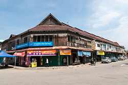
Old colonial style shops
|
||
Bongawan is a municipality in the west of the Malaysian state of Sabah . Bongawan is located in the West Coast Division , about 60 kilometers south of the state capital Kota Kinabalu . Administratively it belongs to the Papar District .
Demographics
According to the last census, the population is 253 people and consists mainly of Malays and Chinese .
etymology
The name derives from bongawan "Bangau" from, the local term for a white egret . This bird species is common in the rice fields in the area.
Attractions
Bongawan is one of the few municipalities in which the old shops from before the Second World War have been preserved. Unlike the larger cities, which were badly destroyed by Japanese and Allied attacks, the wooden buildings from 1939 have stood the test of time. Most of the stores are run by Hakka and Hokkien .
Infrastructure
Bongawan has a stop on the Kota Kinabalu-Tenom line of the Sabah State Railway . A feeder road connects the place with the A2 (Pan Borneo Highway) .
literature
- KG Tregonning: A History Of Modern Sabah (North Borneo 1881–1963) , 2nd edition, University of Malaya Press, Kuala Lumpur, 1965, reprint 1967.
- Owen Rutter: British North Borneo - An Account of its History, Ressources and Native Tribes , Constable & Company Ltd, London, 1922.
- WH Treacher: British Borneo - Sketches of Brunai, Sarawak, Labuan and North Borneo , Singapore, Government print department, 1891.
Web links
Individual evidence
- ↑ a b Population Distribution by Local Authority Areas and Mukims, 2010 (Census 2010) ( Memento of the original from November 14, 2013 in the Internet Archive ) Info: The archive link was inserted automatically and has not yet been checked. Please check the original and archive link according to the instructions and then remove this notice. (PDF; 1.9 MB), page 138


