Sandakan
| Sandakan 山 打 根 Elopura Sandakan |
||
|---|---|---|
| Coordinates | 5 ° 50 ′ N , 118 ° 7 ′ E | |
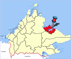
 Location of the city within the Sandakan district Location of the city within the Sandakan district
|
||
| Symbols | ||
|
||
| Basic data | ||
| Country | Malaysia | |
| Sabah | ||
| ISO 3166-2 | MY-12 | |
| Residents | 157,330 (2010) | |
| founding | June 21, 1879 | |
| Website | www.mps.sabah.gov.my | |
| politics | ||
| President | Wong Foo Tin | |
|
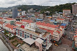
View of the port area of Sandakan
|
||
Sandakan is the second largest city in the Malaysian state of Sabah . It is located on the east coast in the north of the island of Borneo . It belongs to the Sandakan Division area , which includes the districts of Beluran , Kinabatangan , Sandakan and Tongod . In 2010 the city had 157,330 inhabitants. Sandakan is also the seat of the Sandakan district of the same name .
history
Until the early 1870s, the east coast of Sabah belonged to the Sultanate of Sulu, which also includes what is now the south of the Philippines. The first European settlement was made by a Scottish arms smuggler, William Clarke Cowie , who gave the settlement Sandakan its name, "seized place" in the Suluk language. Soon, however, the place was called "Kampung German" (German settlement / settlement of the Germans) when various Germans established bases there. The settlement fell in 1878, including the entire territory of North Borneo, to the Austro-Hungarian consul Baron von Overbeck , who had signed a concession agreement with the Sultan of Sulu. On June 15, 1879, the settlement burned down and was not rebuilt. The British resident, William Burgess Pryer , moved it on June 21, 1879 to a place at the exit of Sandakan Bay, now known as Buli Sim Sim , and named the new settlement Elopura (Beautiful City) ; it was renamed to Sandakan a few years later. The name Elopura is still used today as constituency N45 for the elections for Dewan Undangan Negeri Sabah .
North Borneo came under the administration of the North Borneo Chartered Company in 1881 . In 1883, instead of the previous Kudat, Sandakan was elevated to the capital of North Borneo (today: Sabah) and held this position (at times also under the name Elopura) until 1946. In that year the area became a British crown colony and the administration to Kota Kinabalu (then still Jesselton) as the capital.
During the Second World War , the Sandakan prisoner-of-war camp, which was administered by the Japanese Army, was located just outside the city . This labor camp became famous for the Sandakan death marches , during which around 2,000 British and Australians were killed or died of disease or malnutrition.
economy
As early as the mid-1930s, the export of tropical woods from Sandakan reached the record level of 180,000 cubic meters, making the city the world's largest exporter of hardwood. At the height of the wood boom, Sandakan boasted that it had the largest number of millionaires in the world. Today the importance of wood exports has decreased significantly. But Sandakan still has the second most important port in Sabah after Kota Kinabalu. Mainly palm oil, tobacco, cocoa, coffee and sago are exported from here.
tourism
Tourism is also becoming increasingly important for the up-and-coming Sandakan. From time to time the port is called by cruise ships.
The district of Sandakan is known for its eco-tourist attractions, such as the Sepilok Rehabilitation Center orangutan reintroduction center (approx. 25 km west of the city), the Kepulauan Penyu National Park (Turtle Islands), the Kinabatangan (560 km the second longest river in Malaysia) and the Gomantong Caves , known for their swallow nests , which are still harvested there today.
Infrastructure
Sandakan is connected to the Malaysian domestic network via Sandakan Airport . Today's airport goes back to an airfield that the Japanese occupiers had built by Australian and British prisoners of war during World War II. The airport is about 15 kilometers northwest of the city center.
The city lies at the end of the two-lane Sabahstrasse A4 from Tuaran via Ranau to Sandakan.
Sandakan has extensive port facilities, but these are mainly used to transport goods. There are no notable ferry connections from here.
Attractions
Sandakan was almost completely destroyed towards the end of World War II. The few preserved historical relics of the former capital were combined in 2003 in the Sandakan Heritage Trail (SHT) to form a city tour. The eleven stations of the Historic Path include
- the Masjid Jamik Mosque,
- the MPS Square with the William Pryer Memorial , the monument of the North Borneo Chartered Company , the Sandakan War Memorial and the Sandakan Liberation Monument,
- the 100-step staircase,
- the Agnes Keith house,
- the historic staircase,
- the chinese temple goddess of mercy ,
- the Singapore Road,
- the Anglican Church of St. Michael's and All Angels ,
- the Sam Sing Kung Temple ,
- the Malaysia fountain,
- the Tourist Information Center and
- the Sandakan Heritage Museum as well
- the Sandakan Massacre Memorial .
Just outside the city center, near the airport, is the Sandakan Memorial Park , a memorial on the site of the former prisoner of war camp Sandakan . In the south of the city there is the Batu Sapi , a striking, approx. 4 meter high rock formation created by marine erosion .
Sandakan has been the seat of the Roman Catholic diocese of Sandakan since 2007 . The cathedral is St. Mary’s .
Sandakan District
Sandakan is also the administrative center of the Sandakan District . The district of Sandakan is - based on the number of inhabitants - with 396,290 inhabitants after Kota Kinabalu and Tawau the third largest of the 25 districts of Sabah.
Others
The adventure books of the Italian author Emilio Salgari created a fictional hero, the pirate Sandokan, the "Tiger of Malaysia" , who fights against the historical British colonial ruler James Brooke , Raja of Sarawak . These adventure books, which appeared from 1895, were made into a film in the 1970s. The name of the fictional hero has no relation to the settlement of Sandakan.
Climate table
| Sandakan | ||||||||||||||||||||||||||||||||||||||||||||||||
|---|---|---|---|---|---|---|---|---|---|---|---|---|---|---|---|---|---|---|---|---|---|---|---|---|---|---|---|---|---|---|---|---|---|---|---|---|---|---|---|---|---|---|---|---|---|---|---|---|
| Climate diagram | ||||||||||||||||||||||||||||||||||||||||||||||||
| ||||||||||||||||||||||||||||||||||||||||||||||||
|
Average monthly temperatures and rainfall for Sandakan
|
|||||||||||||||||||||||||||||||||||||||||||||||||||||||||||||||||||||||||||||||||||||||||||||||||||||||||||||||||||||||||||||||||||||||||||||||||||||||||||||||||||||||||||||||||||||||||||||||||||
See also
literature
- Owen Rutter: "British North Borneo - An Account of its History, Resources and Native Tribes" , Constable & Company Ltd, London, 1922.
- WH Treacher: "British Borneo - Sketches of Brunai, Sarawak, Labuan and North Borneo" , Singapore, Government print department, 1891.
- KG Tregonning: "A History Of Modern Sabah (North Borneo 1881–1963)" , 2nd edition, University of Malaya Press, Kuala Lumpur, 1965, reprint 1967.
Web links
Individual evidence
- ↑ a b Census 2010 for Sabah (PDF; 1.9 MB), ed. from the Bureau of Statistics, Malaysia
- ↑ Sandakan to be revitalized when heritage trails are completed ( page no longer available , search in web archives ) Info: The link was automatically marked as defective. Please check the link according to the instructions and then remove this notice. , The Star, December 25, 2010; Retrieved December 9, 2011
- ↑ Population Distribution by Local Authority Areas and Mukims, 2010 (Census 2010) (PDF; 368 kB), page 369


