
Kota Kinabalu
| Kota Kinabalu | |||
|---|---|---|---|
|
|||
| Coordinates | 5 ° 58 ' N , 116 ° 4' E | ||
 Location of the city within the Kota Kinabalu district Location of the city within the Kota Kinabalu district
|
|||
| Symbols | |||
|
|||
| Basic data | |||
| Country | Malaysia | ||
| Sabah | |||
| ISO 3166-2 | MY-12 | ||
| surface | 352.1 km² | ||
| Residents | 199,742 (2010) | ||
| density | 567.3 Ew. / km² | ||
| founding | 1882 | ||
| politics | |||
| mayor | Yang Berhormat Tuan Chan Foong Hin | ||
| Political party | DAP | ||


Kota Kinabalu (emphasis: 'Kota Kinaˈbalu - based on the usual Malaysian abbreviation "KL" for Kuala Lumpur, often abbreviated to KK ; formerly Jesselton ) is the capital of the Malaysian state of Sabah on the island of Borneo . The 2010 census shows a population of 199,742 for the urban area excluding suburbs. Kota Kinabalu is also the seat of the administrative district of the same name, Kota Kinabalu District .
City name
The place on which today's Kota Kinabalu is based was originally a Bajau settlement . There were large stands of the Avicennia tree , which the Bajau Api-Api called and gave the settlement its name.
Other historical names for the square were Singgah Mata ("where the eyes like to linger") and Deasoka ("below the coconut tree"). The latter refers to a village in the southern part of the settlement that was planted with coconut trees.
When the company moved from Gantian to its current location in 1899, the former Api-Api was renamed Jesselton in honor of Charles Jesse . Jesselton was renamed Kota Kinabalu in 1968. The new city name is composed of Kota , the Malay word for "city", and Kinabalu , a mountain about 50 kilometers east of the city.
The various names of the earlier settlements can still be found today in various street and building names Kota Kinabalus, e.g. B. Lintasan Deasoka, Api-Api Center and Jalan Singgah Mata.


history
The North Borneo Chartered Company established its first administrative headquarters on Pulau Gaya in September 1882 with the primary aim of using it as a collection point for jungle products and local goods. The island had already been acquired on December 29, 1877 along with other smaller territories on the west coast on the basis of a treaty with the Sultan of Brunei.
The settlement suffered from a lack of water from the start. As early as 1885 voices were heard calling for the station to be relocated to the mainland. After the port and administration buildings were destroyed and looted on July 9, 1897 during the Mat Salleh Rebellion , the company relocated its administration buildings to the nearby mainland, initially to Gantian, now Sepanggar Bay. Because some of the men in Mat Salleh's retinue came from the Inanam, Menggatal and Mengkabong region, the Chartered Company sought damages from the Sultan of Brunei, who ruled the region at the time. The Sultan ceded other areas of the mainland to the society, including Menggatal, Mengkabong, Api Api, Sembulan, Inaman, Kuala Lama and Mebakut, to replace the goods worth 100,000 Straits dollars stolen from Gaya.
The location in Gantian soon turned out to be problematic, as the bay was unsuitable as an anchorage for larger ships due to its shallow water. In addition, the connection of the city to the railway line, which is already under construction, would have cost the company dearly, as the tracks would have had to be laid through marshy terrain. In 1899, Henry Walker was commissioned by the Land Allocation Commission to find a replacement for Gantian. Walker proposed a strip of land across from Gaya Island, which society approved. Gantian was given up and on November 9, 1899 the groundbreaking ceremony for the construction of "Jesselton" took place.
During the time under the Chartered Company's administration, Jesselton was the center of trading in rubber , rattan , honey and wax .
The North Borneo War Memorial was built in 1923 to commemorate the victims of the First World War .
On January 9, 1942, the city was occupied by the Japanese . Towards the end of the war, Jesselton was almost completely destroyed by bombing by the Allies , so that only three buildings remained. After the war, North Borneo became a British crown colony in 1946 and the rebuilt Kota Kinabalu replaced Sandakan as the capital.
Kota Kinabalu received city status on February 2, 2000.
Infrastructure
Airport
Kota Kinabalu can be reached through Kota Kinabalu International Airport (BKI) ( 5 ° 56 ′ 14 ″ N , 116 ° 3 ′ 6 ″ E ). Malaysia's second largest airport is a hub for domestic and international airlines. The low-cost airline Air Asia uses Terminal 2, which was built in 1957 and reopened in 2007 after a general renovation , which is also known as LCCT (Low Cost Carrier Terminal) . Terminal 1, which was redesigned in 2008, is mainly used by Malaysia Airlines and other international airlines.
railroad
Kota Kinabalu is the starting point of the only railway line from Sabah, which runs from the capital via Beaufort to Tenom .
Buildings
tourism
The buildings of the Sabah Foundation and the Sabah Museum are located in Kota Kinabalu . Also close to Kota Kinabalu is the Tunku Abdul Rahman National Park and a group of heavily forested islands near the Kota Kinabalu coast.
gallery
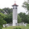
Historic bell tower

town hall

Che Sui Khor Temple

Monument to the fallen 1939/45
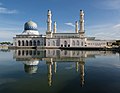
Mosque in Kota Kinabalu (Sabah)


Climate table
| Kota Kinabalu | ||||||||||||||||||||||||||||||||||||||||||||||||
|---|---|---|---|---|---|---|---|---|---|---|---|---|---|---|---|---|---|---|---|---|---|---|---|---|---|---|---|---|---|---|---|---|---|---|---|---|---|---|---|---|---|---|---|---|---|---|---|---|
| Climate diagram | ||||||||||||||||||||||||||||||||||||||||||||||||
| ||||||||||||||||||||||||||||||||||||||||||||||||
|
Monthly average temperatures and rainfall for Kota Kinabalu
Source: wetterkontor.de
|
|||||||||||||||||||||||||||||||||||||||||||||||||||||||||||||||||||||||||||||||||||||||||||||||||||||||||||||||||||||||||||||||||||||||||||||||||||||||||||||||||||||||||||||||||||||||||||||||||||
literature
- KG Tregonning: A History Of Modern Sabah (North Borneo 1881–1963) , 2nd edition, University of Malaya Press, Kuala Lumpur, 1965, reprint 1967
- Regina Lim: Federal-state relations in Sabah, Malaysia: the Berjaya administration 1976-85 , Institute of Southeast Asian Studies, 2008, ISBN 978-981-230-811-5
- Danny Wong Tze Ken: Historical Sabah: Community and Society , Natural History Publications (Borneo) Sdn. Bhd, Kota Kinabalu, 2004, ISBN 983-812-090-1
Individual evidence
- ↑ a b Census 2010 for Sabah (PDF; 1.9 MB), page 137 ed. from the Bureau of Statistics, Malaysia
- ↑ a b Danny Wong Tze Ken, page 7
- ↑ Tregonning, p 57
- ↑ Sawatan, Jackson: Adakah Gaya Sekadar 'Singgah mata' Untuk Pembangkang? . BERNAMA. Archived from the original on September 29, 2007. Retrieved March 8, 2007.
- ^ Danny Wong Tze Ken, page 1
- ^ Danny Wong Tze Ken, page 5
- ^ Danny Wong Tze Ken, pp. 6-7
Remarks
- ↑ The frequently rumored version that the place was named Api-Api ( api: bajau for fire ) by the local Bajau in memory of the settlement on Pulau Gaya that burned down in the Mat-Salleh rebellion , is valid according to the state of research considered obsolete, as the name Api-Api appeared in the contracts of the Chartered Company with the Sultan of Brunei long before the fire. (Source: Danny Wong Tze Ken, page 7)
- ↑ Sultan of Brunei at that time was Sultan Abdul Mumin Ebn Marhoum Maulana Abdul Wahab.
Web links
- Kota Kinabalu on www.sabahtourism.com - Background information on Kota Kinabalu on the official website of the Tourism Board
Large cities Kota Kinabalu (capital) | Sandakan | Tawau
Cities Beaufort | Beluran | Bingkor | Bongawan | Donggongon | Inanam | Kalabakan | Keningau | Kimanis | Kinabatangan | Kinarut | Kota Belud | Kota Marudu | Kuala Penyu | Kudat | Kunak | Kundasang | Lahad Datu | Membakut | Menggatal | Menumbok | Nabawan | Paitan | Papar | Penampang | Pensiangan | Pitas | Putatan | Ranau | Sapulut | Semporna | Sepanggar | Sindumin | Sipitang | Sook | Tambunan | Tamparuli | Telipok | Telupid | Tenom | Tongod | Tuaran | Weston