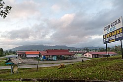
Nabawan
| Nabawan | |
|---|---|
| Coordinates | 5 ° 5 ' N , 116 ° 27' E |
 Location of Nabawan District and City Location of Nabawan District and City
|
|
| Basic data | |
| Country | Malaysia |
| Sabah | |
| ISO 3166-2 | MY-12 |
| height | 300 m |
| Residents | 31,807 (2010) |
| founding | 1974 |
|
Pekan Nabawan
|
|
Nabawan is a small town in the Malaysian state of Sabah . It belongs to the administrative district of the same name ( Nabawan District ) and is 110 kilometers (as the crow flies) southeast of the capital Kota Kinabalu . The city is part of the Interior Division area , which includes the districts of Beaufort , Keningau , Kuala Penyu , Nabawan , Sipitang , Tambunan and Tenom .
geography
The city of Nabawan is 300 m above sea level. The small town is about 64 kilometers from Keningau . The driving distance to the capital Kota Kinabalu is 192 kilometers. Nabawan is connected to Sook and Sapulut via a two-lane asphalt road. Small branch lines within the district are, however, without road surface; Dusty in dry weather and muddy and slippery in the wet season.
history
In the spring of 1974 the administration of the then Pensiangan District Office was transferred from Pensiangan to the newly founded Nabawan. With the Nabawan Scheme - a resettlement plan of the United Sabah National Organization (USNO) - an attempt was made to lure settlers into the lonely area. The plan was not particularly successful. On the one hand it was badly organized, on the other hand it did not take into account the traditionally close family ties and after a while many settlers returned to the region around Pensiangan. The remaining settlers faced the challenge of developing the area from scratch.
Despite the failures, a new, one-story administration building was erected in Nabawan in 1998/99 and staffed by a middle-class administrative officer.
Demographics
According to the last census in 2010, the population of the city of Nabawan is only 576 and consists almost exclusively of Murut , the largest ethnic group.
Attractions
Batu Punggul
The Batu Punggul is a striking rock formation rising steeply from the rainforest, which plays an important role in the legends of the Murut. The rock is located at Kampong Tataluan. To get there from Sepulut, a 2-5 hour trip in a wooden canoe with an outboard motor on the Murut is required.
Kukuik cave
The Kukuik Cave is located near Kampong Salarom. Probably some of it comes from the Second World War. Corresponding remains and human skeletons were discovered in the vicinity of the cave.
Salt water spring
The salt water spring is also at Kampong Salarom. The source can be reached from the settlement after a one-hour walk through the jungle. The salt water flowing from the spring is rich in crystalline mineral salt. The inhabitants of the Salarom settlement still cover their needs for table salt from this spring. The existence of the salt water spring was first documented in 1913 by a group of prospectors from the British Shell .
See also
literature
- KG Tregonning: A History Of Modern Sabah (North Borneo 1881–1963) , 2nd edition, University of Malaya Press, Kuala Lumpur, 1965, reprint 1967.
- Owen Rutter: British North Borneo - An Account of its History, Ressources and Native Tribes , Constable & Company Ltd, London, 1922.
- WH Treacher: British Borneo - Sketches of Brunai, Sarawak, Labuan and North Borneo , Singapore, Government print department, 1891.
Web links
- Legend of Batu Punggul
- Ministry of Culture, Environment and Tourism, Sabah: Nabawan - Background Paper (PDF; 1.8 MB), 1998
Individual evidence
- ↑ a b Census 2010 for Sabah (PDF; 1.9 MB), p. 139, ed. from the Bureau of Statistics, Malaysia
- ↑ http://www.sabah.com.my/butitin/location.html
- ↑ Status: February 2013; Checked on site by the author.
- ↑ http://www.sabah.com.my/butitin/history.html
- ↑ Brief History of Nabawan District Office ( Memento of the original from October 14, 2013 in the Internet Archive ) Info: The archive link was inserted automatically and has not yet been checked. Please check the original and archive link according to the instructions and then remove this notice. , Accessed February 2, 2012
