Tambunan
| Tambunan | |
|---|---|
| Coordinates | 5 ° 40 ′ N , 116 ° 22 ′ E |
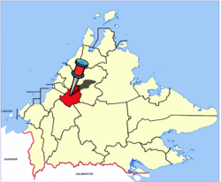
 Location of the city in the Tambunan district Location of the city in the Tambunan district
|
|
| Basic data | |
| Country | Malaysia |
| Sabah | |
| ISO 3166-2 | MY-12 |
| Residents | 2553 (2010) |
|
Gombunan Tamadon Memorial and Unity Stone
|
|
Tambunan is a city in the Malaysian state of Sabah . It is located in the mountainous region of the Crocker Ranges in the north of the island of Borneo . Tambunan belongs to the administrative district of the same name, Tambunan District, and is 76 kilometers southeast of the capital Kota Kinabalu . The city is part of the Interior Division area , which includes the districts of Beaufort , Keningau , Kuala Penyu , Nabawan , Sipitang , Tambunan and Tenom . East of the city of Tambunan rises the second highest mountain in Sabah at 2,642 meters, the Trus Madi .
Demographics
The city's population is 2533 people according to the last census. Tambunan is mainly populated by the indigenous group of the Kadazan-Dusun (86%), the rest of the population is made up of Malays, Chinese and other indigenous groups of Sabah. Tambunan is divided into 13 kampung:
- Kampung Sunsuron
- Kampung Kinabaan
- Kampung Tontolob
- Kampung Pantai
- Kampung Kipaku
- Kampung Kepayan Baru
- Kampung Kepayan Lama
- Kampung Tombotuon
- Kampung Tibabar
- Kampung botung
- Kampung Tampasak Liwan
- Kampung Tonop
- Kampung Kirokot
history
origin of the name
According to legend, the name Tambunans goes back to two originally rival tribes, the Tamadon and Gombunan, who settled in this area. United by the common enemy, the Tonsudong tribe, they successfully defended their territory together. Tambunan was created by amalgamating the names of both tribes; Tamadon and Gombunan became Tambunan.
Mat Salleh Rebellion
Tambunan is one of the scenes of the Mat Salleh rebellion between 1894 and 1900. The leader, Datu Paduka Muhammad Salleh, better known as Mat Salleh, had built a fort northeast of Tambunan after the peace negotiations in Menggatal northeast of Tambunan with the consent of the British. In 1899 the Tambunan government demanded back; However, Mat Salleh refused to agree and the fighting flared up again. On January 31, 1900, he was shot in Kampung Tibabar, Tambunan.
Attractions
Mat Salleh Memorial
At the point where Mat Salleh's fort stood ( 5 ° 42 ′ 54.27 ″ N , 116 ° 23 ′ 46.56 ″ E ), the British erected a memorial with the inscription "This plaque marks the site of Mat Salleh's Fort which was captured by the North Borneo Armed Constabulary on the 1st February 1900. During this engagement, Mat Salleh, who for six years led a rebellion against the British Charted Company administration, met his death. "
Today, Mat Salleh is no longer described as a rebel, but as a folk hero, revolutionary or freedom fighter. The Sabah government took this into account by converting the site of the triumph of the British over the "rebel" in the middle of rice fields into the "Mat Salleh Memorial" in 2000. The memorial plaque to the former fort of Mat Salleh and the place of his death is now housed in a small park. In the memorial, reminiscent of a bunker, there is a small exhibition about Mat Salleh.
Rafflesia Forest Reserve
A little outside of Tambunan is the "Rafflesia Forest Reserve" established in 1984, which serves to protect the world's largest flower, the Rafflesia . The Rafflesia Forest Reserve covers an area of 356 hectares and is located on the road from Tambunan to Kota Kinabalu. Access to the reserve is from the Rafflesia Information Center . Rafflesia pricei is mainly found within the reserve .
Infrastructure
Tambunan is connected to the capital of Sabah by the Kota Kinabalu-Tambunan-Keningau Highway. The two-lane road runs over the Crocker Ranges and is notorious for its steep incline. The north running road to Ranau is one of the worst roads in Sabah. It has many potholes and damage from landslides.
Tambunan Village Resort Center
The Tambunan Village Resort Center (TVRC) is the starting point for mountain tours on the Trus Madi . In addition to overnight accommodation, the TVRC arranges high mountain carriers , mountain guides, food for mountaineers and the necessary permit from the Ministry of Forestry for climbing.
See also
literature
- KG Tregonning: A History Of Modern Sabah (North Borneo 1881–1963) , 2nd edition, University of Malaya Press, Kuala Lumpur, 1965, reprint 1967.
- Owen Rutter: British North Borneo - An Account of its History, Ressources and Native Tribes , Constable & Company Ltd, London, 1922.
- WH Treacher: British Borneo - Sketches of Brunai, Sarawak, Labuan and North Borneo , Singapore, Government print department, 1891.
Individual evidence
- ↑ a b Census 2010 for Sabah (PDF; 1.9 MB), p. 140, ed. from the Bureau of Statistics, Malaysia
- ↑ inscription on Gombunan-Tamadon Memorial in Tambunan; verified on site on November 19, 2011
- ↑ Mount Trus Madi Climbing Tips ; Accessed January 9, 2012
Web links
- Rafflesia forest reserve website ; Accessed January 8, 2012
Remarks
- ↑ Translation: "This plaque marks the site of Mat Salleh's Fort, which was captured by the North Borneo Police Force on February 1, 1900. During this confrontation, Mat Salleh, who had led the rebellion against the administration of the British Chartered Company for six years, found , death."
- ↑ In November 2011 the facility is in an unkempt condition; the exhibition has little didactic structure and is not understandable without prior knowledge.


