Membakut
| Membakut | ||
|---|---|---|
|
|
||
| Coordinates | 5 ° 28 ' N , 115 ° 47' E | |
| Basic data | ||
| Country | Malaysia | |
| Sabah | ||
| ISO 3166-2 | MY-12 | |
| Residents | 516 (2010) | |
| Website | www.sabah.gov.my/dkmk/ | |
| politics | ||
| Assistant District Officer | Tuan Hj. Sanudin Hj. Ismail | |
|
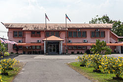
Seat of the local government in Membakut
|
||
Membakut is a small town and a sub-district in the western part of the Malaysian state of Sabah . Membakut is located in the Interior Division , about 70 kilometers south of the state capital Kota Kinabalu . Administratively it belongs to the Beaufort .
Origin of name
The name Membakut is derived from Bakut , which means fort in the local Brunei dialect . The prefix mem turns the noun into a verb, so that Membakut can be translated as "make a fortification" .
Demographics
According to the last census, the population of the small town is 516 and consists mainly of Brunei Malay , Kadazan-Dusun , Paitan, Javanese , Bisaya and Chinese. The Membakut sub-district, which was founded on April 7, 1977, includes 38 villages. According to the local government, the total population of the sub-district is an estimated 21,900 people, spread over an area of 138 km².
history
Membakut was an independent territory within the Brunei Jajahan system . It became official apanage ( kuripan ) in 1879 by Wazir Pengiran Pemanca, who had the area administered by a Brunei nobleman, Pengiran Maharaja Lela. Membakut was acquired by the North Borneo Chartered Company in 1900 and incorporated into the state of British North Borneo .
Membakut's origins go back to a village about 5 kilometers from the coast in an area called Bua . The village known today as Kampung Brunei belongs to the Mukim Bandau (see below). The later naming of the village and the renaming of the area and the river to "Membakut" was carried out by the influential chief OKK Haji Saman bin Mohd Yaakub.
The development of today's historic center followed the construction of the railway line from Beaufort to Jesselton at the beginning of the 20th century. In the years 1920 to 1930 a first row of traditional, wooden shophouses were built, which were oriented towards the railway line and provided space for the tamu , the weekly market. In the years after 1910, construction of the Pei Yin Primary School had already begun.
Historic architecture
Membakut is one of the cities along the west coast, parts of which have been preserved to this day. These include, among other things
- the two shops to the west of the railway line and a workshop complex from before the Second World War,
- a shop from the 1950s east of the railway line,
- the historic Pei Yin Primary School ,
- the blue house , probably the former home of a teacher and
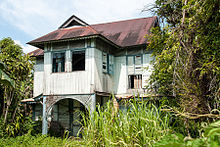
- a colonial-style house that is one of the oldest houses on the west coast (built around 1913–1916).
Another shophouse east of the railway line fell victim to a fire in the spring of 2011.
economy
The area around Membakut is characterized by agriculture. The majority of the population is engaged in rice cultivation or in the cultivation of natural rubber trees and oil palms or earns a living in fishing.
Infrastructure
Membakut has a stop on the Kota Kinabalu-Tenom railway line of the Sabah State Railway .
politics
Membakut belongs to the constituency P.176 ( Kimanis ) and is represented in the Malaysian parliament by YB Datuk Anifah Hj. Aman Ahli. In the Legislative Assembly of Sabah ( Dewan Undangan Negeri Sabah ) the sub-district is by YB Datuk Hj. Mohd. Arifin Mohd Arif Adun from constituency Membakut N.24 represented.
Local government
Pejabat Daerah Kecil Membakut
The local government is located in ( mal. ) Pejabat Daerah Kecil Membakut , which means something like "sub-district office". The sub-district was officially created on April 7, 1977 and initially resided in an older building under the direction of Assistant District Officer Ibrahim Hj. Ahmad. The current office building was built from 1978 to 1979 and inaugurated on October 28, 1979 by the then Prime Minister of Sabah Harris Salleh .
Division of the sub-district
The Membakut sub-district is divided into three municipal administrations (mukim) :
- MUKIM I (Pimping / Binsulok) with the settlements ( kampung ) Pimping, Laut Pimping, Tengah Pimping, Ulu Pimping, Paya Pimping, Tambing Pimping, Batung, Pisang, Saga-Saga, Rumah Lama, Gala, Tukong, Belandas, Gan-dawari , Mandaya, Sijamban, Sitamu Kuning, Madang, Terusan, Binsulok, Laut Binsulok, Padang Binsulok, Ulu Binsulok, Seberang, Mantabawan and Likas.
- MUKIM II (Bandau) with the settlements ( kampung ) Bandau, Pamparingan, Biau, Laganggon, Budak, Bawan, Imbahaton, Kebuluan, Manggis, Sumbiling, Kabuh, Saliban, Bahab, Kulintangan, Tamalang, Kambuangon, Pinopok, Luba-Luba, Sungai So, Limbutong, Kumpat, Kilau, Dakutan, Laputong, Libubon, Kampuluan, Tandoi, Gana, Binubang, Kinanap, Tamoi, Limadang, Labak, Matunjong, Kayai, Dindong, Bangkawat, Jambo, Gapu, Takapan, Gassan, Brunei and Gangas.
- MUKIM III (Mawao) with the settlements ( kampung ) Tandian, Piasau, Dungau, Tahak, Bingkulas, Mandangin, Papas, Rancangan Mawao, Limpayau, Lampijas, Jambatan Baru, Mawao Laut, Layun, Mawao Ulu, Tiong Baru, Kiulu Baru, Lumat , Lintap, Mandaya, Lampun and Bungar.
- MUKIM IV (Bambangan) with the settlements ( kampung ) Baitam, Sinoko, Sindok, Bambangan, Lumantak, Lembah Poring, Poring Tengah, Paung Maragang, Angitan, Poring Maragang, Inantul, Bambangan Ulu, Pusak and Tamalang / Penopok.
literature
- KG Tregonning: A History Of Modern Sabah (North Borneo 1881–1963) , 2nd edition, University of Malaya Press, Kuala Lumpur, 1965, reprint 1967.
- Owen Rutter: British North Borneo - An Account of its History, Ressources and Native Tribes , Constable & Company Ltd, London, 1922.
- WH Treacher: British Borneo - Sketches of Brunai, Sarawak, Labuan and North Borneo , Singapore, Government print department, 1891.
Web links
Individual evidence
- ↑ a b Population Distribution by Local Authority Areas and Mukims, 2010 (Census 2010) (PDF; 1.9 MB), page 138
- ↑ a b c Richard Nelson Sokial: Colonial Townships in Sabah: West Coast , Homeland Publisher Sdn Bhd, 2012, page 46, ISBN 978-983-40734-4-2
- ↑ a b Background information on the sub-district ; Accessed April 19, 2012
- ^ DS Ranjit Singh: The Making of Sabah 1865-1941 - The Dynamics of Indigenous Society , 3rd edition (2011), page 69, ed. from the Prime Minister's Office, Kota Kinabalu, Sabah
- ^ Colonial Office, British North Borneo Company Papers CO 874/235
- ^ Colonial Office, British North Borneo Company Papers CO 874/73
- ^ Singh, 154


