
Bridges and tunnels in New York Harbor
According to the city of New York, there are 2,027 bridges in New York City (approx. 60 smaller bridges in Central Park alone). This is primarily about the bridges and tunnels in the New York harbor area as crossings of the main waters in and around New York / Manhattan. The longest bridge is the Verrazzano-Narrows Bridge to the south between Staten Island and Brooklyn across the entrance to the Atlantic .
- The bridges over the East River to Manhattan on its northeast bank are from north to south: Throgs Neck Bridge, Bronx-Whitestone Bridge, the railroad bridge from Randalls Wards or Park Ave, Third Ave Bridge, Willis Ave Bridge, Triborough Bridge , Queensboro Bridge , Williamsburg Bridge , Manhattan Bridge and the Brooklyn Bridge .
- On the west bank there is the Bear Mountain Bridge over the Hudson in the very north , followed by the Governor Malcolm Wilson Tappan Zee Bridge ( Tappan Zee Bridge for short with the I-87 / I-287 - New York State Thruway , also Dewey Thruway) and directly north of the center the George Washington Bridge .
In addition to these main bridges to / from Manhattan, there are many normal bridges as well as 25 movable bridges throughout New York: two draw-in bridges, seven swing bridges, four lifting bridges and twelve drawbridges. Since bridges and tunnels are always about the connection of two areas, it makes sense not to limit yourself to the New York metropolitan area, but also to consider the various partners, mostly local authorities, who were involved in the construction.
The term New York Harbor is above all a rough geographical description of the area on the border between the two states of New York and New Jersey , because also the so-called facilities of the joint port authority of the two US neighboring states, the Port Authority of New York and New Jersey (PANYNJ) , by far do not include all port facilities and regulating issues relating to road and rail traffic to and from New York.
bridges
East River Bridges


- (Order upstream)
| Surname | Completion | length | Remarks | image |
|---|---|---|---|---|
| Brooklyn Bridge | 1883 | 1825.00 m | Oldest suspension bridge |

|
| Manhattan Bridge | 1909 | 2089.00 m | 7 lanes and 4 tracks, pedestrian and bicycle lanes ( IND Sixth Avenue Line , BMT Broadway Line ) |

|
| Williamsburg Bridge | 1903 | 2227.48 m | Combined road and rail bridge ( BMT Nassau Street Line / BMT Jamaica Line ) |

|
| Queensboro Bridge | 1909 | 1135.00 m | Also called 59 Street Bridge (Bridge of 59th Street) known |

|
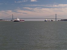
| Roosevelt Island Bridge | 1955 | 876.91 m | East Channel only. Lift bridge (30 m) the rear bridge in the picture |
|
| Triborough Bridge | 1936 | 1569.72 m | for Interstate 278 |

|
| Hell Gate Bridge | 1916 | 310.00 m | Railway bridge (with further segments 5181.60 m total access and exit structures) the rear (red) bridge in the picture |
|
| Francis Buono Bridge | 1966 | 1280.16 m | Connects Rikers Island with Queens, hence Rikers Island Bridge | |
| Bronx-Whitestone Bridge | 1939 | 1149.10 m | Interstate 678 |

|
| Throgs Neck Bridge | 1961 | 886.97 m | Interstate 295 |

|
Harlem River
The Harlem River is an estuary 13 kilometers long and 120 meters wide with a tidal range between the Hudson River and the East River. It is made up of the actual Harlem River in the east and the Harlem River Ship Canal and Spuyten Duyvil Creek in the north. It is spanned by a total of 15 bridges. They connect Manhattan Island to the American mainland with Ward's Island , the Bronx and Marble Hill .
| Surname | Completion | length | Remarks | image |
|---|---|---|---|---|
| Ward's Island Bridge | 1951 | 285.6 | Only pedestrians open to shipping in the background the Hell Gate Bridge |

|
| Robert F. Kennedy Memorial Bridge (formerly: Harlem Lift Bridge, as part of the Triborogh Bridge) | 1936 | 1569.72 | Harlem Lift Bridge as a separate part of the Robert F. Kennedy Memorial Bridge |
.jpg)
|
| Willis Avenue Bridge | 1901 | 979 m | In the picture the old swing bridge under 3rd Ave. Bridge seen through it, behind it the Harlem River Lift Bridge and behind it on the right the Hell Gate Bridge. In the meantime a new swing bridge has been installed. |

|
| Third Avenue Bridge | 1898 | ? |

|
|
| Park Avenue Bridge | 1956 | ? | Metro-North Railroad railway bridge |

|
| Madison Avenue Bridge | 1910 | ? |

|
|
| 145th Street Bridge | 1905 | ? |

|
|
| Macombs Dam Bridge | 1895 | 774 |

|
|
| High bridge | 1848 | 440 | Formerly: Aqueduct Bridge (see also: Croton Aqueduct ); pedestrians and cyclists only |

|
| Alexander Hamilton Bridge | 1963 | 724 |
|

|
| Washington Bridge | 1888 | 723.9 | In the picture the front bridge |

|
| University Heights Bridge | 1908 | 82 |

|
|
| Broadway Bridge | 1962 | ? | Also Harlem Ship Canal Bridge; US 9 IRT Broadway - Seventh Avenue Line (trains)
|

|
| Henry Hudson Bridge | 1936 | 673 |
|

|
| Spuyten Duyvil Bridge | 1900 | ? | Railway swing bridge, Amtrak Empire Connection |

|
Hudson bridges

| Surname | completion | length | Note | image |
|---|---|---|---|---|
| Above Manhattan | ||||
| Bear Mountain Bridge | 1924 | 687 m |

|
|
| Tappan Zee Bridge | 1955 | 4881 m | (during the Dewey Thruway) |

|
| At the height of Manhattan | ||||
| George Washington Bridge | 1931 | 1451 m | Used by 320,000 vehicles every day. Originally built with only one carriageway level; In 1962 a second level was hung below. 4 lanes per direction or 3 lanes per direction in the basement + pedestrians etc. |

|
| Below Manhattan | ||||
| Verrazzano-Narrows Bridge over the Narrows Strait | 1964 | 2270 m | connects Staten Island u. Brooklyn |

|

New Jersey
On the west bank of the Hudson is the
- Vincent R. Casciano Memorial Bridge (from 1956; previously only briefly Newark Bay Bridge). It connects Newark and Bayonne in four lanes . The main field with the largest span measures 390 meters.
Staten Island – New Jersey
Run to and from New Jersey
- the Goethals Bridge ,
- the Bayonne Bridge and
- the Outerbridge Crossing .
Newtown Creek
| Surname | Bj. | length | Remark. |
|---|---|---|---|
| Kosciuszko Bridge * | 1939 | Along I-278 | |
| Pulaski Bridge | 1954 | McGuinness Blvd. | |
| JJ Byrne Memorial Bridge | 1987 | old Greenpoint Avenue Bridge | |
| Grand Street Bridge | |||
| Metropolitan Avenue Bridge |
The * old Kosciuszko Bridge (1939) between the boroughs of Queens and Brooklyn was deliberately blown up for demolition (Oct. 2017). Its forerunner was the Meeker Avenue Bridge, a swing bridge. A new bridge at this point should be completed in three years.
tunnel
- Listed upstream:

Under the East River
- Brooklyn-Battery Tunnel - Interstate 478 ( I-478 )
-
Joralemon Street Tunnel - IRT Lexington Avenue Line

-
Montague Street Tunnel - BMT Broadway Line


-
Clark Street Tunnel - IRT Broadway - Seventh Avenue Line


-
Cranberry Street Tunnel - IND Eighth Avenue Line


-
Rutgers Street Tunnel - IND Sixth Avenue Line

-
14th Street Tunnel - BMT Canarsie Line

- East River Tunnels on the Pennsylvania Tunnel and Terminal Railroad to Penn Station - ( Amtrak and Long Island Rail Road ) - subway line / station
- Queens-Midtown Tunnel - Interstate 495 (I-495)
-
Steinway Tunnel - IRT Flushing Line

-
53rd Street Tunnel - IND Queens Boulevard Line


-
60th Street Tunnel - BMT Broadway Line

-
63rd Street Tunnel - IND 63rd Street Line and currently unused Long Island Rail Road tunnel
- East River Gas Tunnel , the first underwater tunnel in the New York City area
Under the Harlem River
- Lexington Avenue Tunnel - NYCS Lexington - Subway Line / Station
- 149th Street Tunnel - NYCS White Plains south - Subway line / station
- Concourse Tunnel - NYCS Concourse south - Subway line / station
Under the Hudson
- Downtown Hudson Tubes (Montgomery-Cortlandt Tunnels) - ( PATH )
- Holland Tunnel - ( I-78 ; PA)
- Uptown Hudson Tubes (Hoboken-Morton Tunnels) - ( PATH )
- Access to the Region's Core (planning 1995, start of construction: 2009)
- North River Tunnels (western approach to Pennsylvania Station ), built by the Pennsylvania Railroad , used by Amtrak and New Jersey Transit
- Lincoln Tunnel - (Route 495 (NJ 495) / Interstate 495 (I-495); PA)
- (PA) = this tunnel is operated by the PA.
administration
The following seven bridges are operated by the Triborough Bridge and Tunnel Authority (MTA):
- Robert F. Kennedy Memorial Bridge (formerly Triborough Bridge),
- Bronx-Whitestone Bridge (Bronx with Queens)
- Verrazzano-Narrows Bridge ( Brooklyn with Staten Island )
- Throgs Neck Bridge (Bronx with Queens)
- Henry Hudson Bridge (Manhattan with the Bronx)
- Marine Parkway-Gil Hodges Memorial Bridge (Brooklyn with Queens- Rockaway peninsula )
- Cross Bay Veterans Memorial Bridge (Queens — Broad Channel also with the Rockaway peninsula)
... and operated two tunnels:
- Brooklyn-Battery Tunnel (Brooklyn with Manhattan)
- Queens Midtown Tunnel (Queens with Manhattan)
See in particular the Metropolitan Transportation Authority (MTA) of NY State with the MTA bridges and tunnels and public transport in the city and region.
The Brooklyn Bridge , Manhattan Bridge , Williamsburg Bridge, and Queensboro Bridge , among others, are administered by the New York City Department of Transportation . There are also 25 lifting bridges such as the Broadway Bridge and five tunnels.
See also
Web links
- nycroads.com to the Brooklyn-Battery Tunnel (English)
- Hudson River Crossings (sorted by street route)
Individual evidence
- ↑ https://streeteasy.com/blog/nyc-bridges-11-new-york-bridges/. Retrieved June 13, 2020 .
- ↑ Bike Brooklyn: Frequently Asked Questions. In: The Bridges of NYC. September 18, 2007, accessed June 13, 2020 .