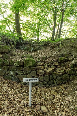
Caldern Castle
| Caldern Castle | ||
|---|---|---|
|
Ring wall of the castle |
||
| Creation time : | 9/11 century | |
| Castle type : | Höhenburg, spur location | |
| Conservation status: | Foundations, remains of trenches | |
| Place: | Lahn valley | |
| Geographical location | 50 ° 50 '20.8 " N , 8 ° 39' 17.6" E | |
| Height: | 315 m above sea level NHN | |
|
|
||
The castle Caldern is the ruins of a medieval Spur castle on 315 m above sea level. NN near the district of Caldern in the municipality of Lahntal in the Marburg-Biedenkopf district in Hesse . Neither the construction period nor the owner are known of the castle. The castle was probably built over a previous building in the 11th century.
location
The remains of the tower castle are located on a projecting, wooded knoll about 500 meters southwest of Caldern and east-southeast of the Rimberg . The almost circular hilltop drops off steeply on all sides, only in the south the hilltop is linked by a flat saddle with a second hilltop. The remains of the wall are to the west of the L 3288 state road, from which a small forest path leads to the wooded Doppelkuppe. Surrounded by agricultural land all around, a large forest area begins just a few dozen meters southwest, and extends northwest to the Rimberg.
Plant and history
The castle is said to have been mentioned for the first time around 800 (probably in connection with the first mention of the place) and for the last time in the 11th century.
All that remains of the small castle complex are the remnants of the northwest-facing residential tower , the oval-shaped circular wall on the rock to the north and a ditch separating the southern crest. The keep had a footprint of 7.5 (NW-SE) by 10 meters (SW-NE) and a wall thickness of around 1.4 meters. The entire castle had an oval base with a diameter of about 28 (SW-NE) by 23 meters (NW-SE).
On December 2, 1944, a German fighter plane crashed into the mountain after being shot down by an American fighter plane . The 19-year-old pilot was killed. There has been a memorial stone at the crash site since 2007.
literature
- Michael Losse: The Lahn castles and palaces . Imhof Verlag, Petersberg 2007, ISBN 978-3-86568-070-9 .
- Georg Landau: Historical-topographical description of the desolate localities in the Electorate of Hesse and in the Grand Ducal Hessian parts of the Hessengaue, the Oberlahngaue and the Ittergaue . 1858.
Individual evidence
- ↑ Norbert Buthmann, Norbert Goßler, Axel Posluschny, Helmut Valand, Benno Zickgraf: Modern prospecting methods in castle research - Archaeological investigations on the medieval castle complex of Lahntal-Brungershausen / Hessen . In: Castles and Palaces . 38, issue 1998 II. Braubach / Rhein 1998, p. 80-87 .
- ↑ fliegerschicksale.de.tl
Web links
- "Burg (Caldern), Marburg-Biedenkopf district". Historical local dictionary for Hessen. (As of November 4, 2010). In: Landesgeschichtliches Informationssystem Hessen (LAGIS).


