
Burgstall Alter Rothenberg
| Burgstall Alter Rothenberg | ||
|---|---|---|
 Image 1: Wall moat of the Alter Rothenberg castle stables (2010) |
||
| Creation time : | around 1200 | |
| Castle type : | Two-part hilltop castle in a summit location | |
| Conservation status: | Burgstall | |
| Standing position : | Reichsministeriale | |
| Construction: | Unknown | |
| Place: | Simmelsdorf- Lochhof | |
| Geographical location | 49 ° 34 ′ 46.6 " N , 11 ° 19 ′ 30.3" E | |
| Height: | 505.9 m above sea level NN | |
|
||

The Burgstall Alter Rothenberg is a former high medieval aristocratic castle that lies above the solitude of Lochhof on the Alten Rotenberg of the same name, also known as Reisberg, in the municipality of Simmelsdorf in the Middle Franconian district of Nürnberger Land in Bavaria , Germany . The castle is almost completely gone today, only very few remains are evidence of it.
The castle stable is freely accessible at all times.
Geographical location

The former castle is located in the western part of the Franconian Alb at 505.3 m above sea level. NN high summit of the Old Rotenberg , which is also known as the Reisberg . The Alte Rotenberg is located at the southern end of a small chain of hills extending from north to south, which is bordered on the west side by the Röttenbach valley and east by the Schaittach valley . The Burgstall is about 150 meters above the valley and about 640 meters north-north-west of the solitude of Lochhof or 2,500 meters north-north-west of the Catholic parish church of Sankt Kunigund in Schnaittach .
There are other former medieval castles in the vicinity: a few kilometers north-northeast of the Burgstall on the Hienberg above the Rampertshof, and a little further east-northeast, the ruins of Osternohe above the village of the same name. The Rothenberg Fortress above Schnaittach, which was replaced by a successor to the castle on the Old Rothenberg, is about 3.8 kilometers to the south-east. To the northwest is the Hainburg castle stable on the 507 meter high Küheberg above Igensdorf .
History of the castle
It was assumed that the remains of the fortifications on the summit of the Altes Rotenberg were prehistoric ramparts until an excavation in 1935 with metal and ceramic finds revealed a settlement around the year 1200.
The name Rothenberg probably goes back to the reddish color of the iron sandstone found here , but could also refer to "cleared mountain". The nearby Lochhof (Fig. 2) is probably the service yard of the medieval castle.
In 1254 the imperial ministerial family von Hiltpoltstein , which also named itself after the castle Lauf, named itself for the first time with Hilteboldus de Rotenberge after the castle. They probably built their own castle in the first half of the 12th century. The real estate on which the castle stood, however, was in the hands of the bishopric of Bamberg , over which the Hohenstaufen exercised the bailiwick through their subordinates . It is possible that the Rotenbergers used the weakness of the kingship after 1241/50 to build their own complex, as they first named themselves after the castle at the beginning of the interregnum . The family appears in the documents for the last time in 1285, it expired between 1285 and 1289.
The castle then came through the marriage of a daughter of Hiltpold to the Lords of Wildenstein , who had their eponymous headquarters near Dietfurt an der Altmühl . The ducal Bavarian ministers sat with Dietrich I. von Wildenstein and his sons at Rotenberg Castle from 1298, and also adopted the Hiltpoltsteiner coat of arms. Heinrich IV von Wildenstein von dem Rotenberge was in the service of Duke Rudolph of Bavaria in 1297 .
At the beginning of the 14th century, Rotenberg Castle was destroyed, as archeologically proven layers of fire indicate. This destruction could be related to the feud between Count Gebhard VII von Hirschberg , Count von Öttingen and King Albrecht against the Bavarian Duke, in which numerous castles were destroyed in 1301.
Between the years around 1280 and 1316, the Rotenberge castrum is still mentioned in Bamberg necrologists , after which Rotenberg Castle was finally destroyed or abandoned. In 1350 only the Rotenberg is mentioned in a place name ( Weygenheimstorf pei dem Rotenperg ), from 1366 even the Rotenberg is referred to as Reisberg ( Weygenstorf under the Reisberg ).
The reason for the abandonment of the castle on the Old Rotenberg was the construction of a new castle on the "new" Rothenberg, a little to the east, around the year 1330, at the place where today's Rothenberg Fortress is located.
Today the place of the former castle is densely wooded, only the section ditch between the outer and main castle, the surrounding ditch of the main castle and in places the heavily sanded moat of the outer castle are preserved. Today a hiking trail leads directly through the trench.
The ground monument registered by the Bavarian State Office for the Preservation of Monuments as "Medieval Castle Stables " has the monument number D-5-6433-0172.
Description of the castle stables
The former hilltop castle is located on the highest point of the Old Rotenberg (Fig. 2), a flat and oval-shaped dome that slopes steeply and deeply down to the valley, except for the slightly sloping northwestern side.
The area of this relatively large summit castle is oval in shape and is about 220 meters long and 100 meters wide. These dimensions were probably also the reason for assuming a prehistoric complex. It is divided into a bailey and a main castle of about the same size , which is surrounded by a shared moat with a partial outer wall.
The outer bailey was presumably on the less steeply sloping west side, the ring moat that once protected it is now heavily sanded and can only be seen on its south side (Fig. 3 and 4). On the north side, a terrace indicates the continuation of the trench. The east side of the outer bailey is bounded over the entire width by a ditch between the outer and main bailey. Your plateau has an approximately trapezoidal area with the dimensions of about 100 by 80 meters. The entrance to the castle was probably on the south side. Traces of building are no longer visible except for a small 5 by 3 meter rectangular hill on the moat leading to the main castle.
Between the outer bailey and the main castle, which is roughly the same size, there is a section ditch about 6 meters deep and 10 to 12 meters wide at the top (Fig. 5), which runs straight from north to south. The bottom of the trench is still 4 to 4 meters wide at both ends, the middle of the trench is severely narrowed by a landslide. At the eastern and especially at the northern end of the ditch a large overburden hill has been preserved, the northern one jumps out about 20 meters like a bastion from the steep slope here, and then also drops very steeply towards the valley (Fig. 6).
The area of the main castle was presumably located on the east side, which is better protected by the steep slope of the site. The irregularly oval-shaped and uneven surface, partly interspersed with smaller hollows and mounds of earth, has a greatest length of 100 meters from north to south, and a greatest width of about 80 meters. Its west side was protected by the trench section, the three remaining sides are surrounded by a distinctive ring trench with an outer wall (Fig. 1 and 7). The only remnant of the former development is an approximately 30 meter long wall, which is still approximately one meter high and 5 meters wide, and runs along the western edge of the main castle directly along the section ditch. Presumably, access to the main castle was via a bridge over the section ditch. The ring trench with outer wall was curved several times and interrupted by forest drives around the main castle, and is still 4 to 8 meters wide and one to three meters deep. Wall cuts gave no evidence of built-in or superstructures made of wood or stone, only a two-tier earth face weir on the inside of the wall was found.
Since only small remains of the foundations were found in the area of the castle complex, the excavators concluded in 1935 that “buildings made of wood, possibly with stone foundations”.
Images of the castle stables

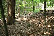
Image 3: The southern part of the moat of the outer bailey (2010)

Figure 4: The southern part of the ring trench of the outer bailey (2010)

Figure 5: The section ditch between the main castle on the right and the outer castle from the south (2010)

Figure 6: The northern overburden mound from the west (2010)
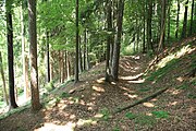
Photo 7: The southern part of the moat of the main castle (2010)


literature
- Daniel Burger : Simmelsdorf: The “Alter Rothenberg” stables on the Reisberg. In: Alfried Wieczorek (Hrsg.): Excursions to archeology, history and culture in Germany, Volume 52: Nuremberg and Nürnberger Land - excursion destinations between Pegnitz and Franconian Alb. Konrad Theiss Verlag , Stuttgart 2010, ISBN 978-3-8062-2368-2 , pp. 224-226.
- Robert Giersch, Andreas Schlunk, Berthold Frhr. von Haller: Castles and mansions in the Nuremberg countryside . Published by the Altnürnberger Landschaft e. V., Lauf an der Pegnitz 2006, ISBN 978-3-00-020677-1 , pp. 28-29.
- Walter Heinz: Former castles in the vicinity of Rothenberg - A selection, 1st part: From Schnaittach to Wildenfels (Vom Rothenberg and its surroundings, issue 15/1) . Published by the Heimatverein Schnaittach e. V., Schnaittach 1992, pp. 1-6.
- Horst Wolfgang Böhme (Ed.): The Salier - Castles of the Salierzeit, part 2: In the southern landscapes of the empire . 3. Edition. Jan Thorbecke Verlag, Sigmaringen 1992, ISBN 3-7995-4134-9 , p. 194ff.
Web links
- Burgstall Alter Rothenberg on the page "Castles and manors in the Nuremberg countryside"
References and comments
- ^ Topographical map 1: 25000, sheet 6533 Lauf ad Pegnitz
-
^ Burgstall Hainburg on the page of the BLfD
About the Burgstall see: Hellmut Kunstmann: Mitteilungen der Altnürnberger Landschaft . December 1953, volume 2, issue 3, pp. 14–19. - ↑ Heinz 1992, p. 2.
- ↑ Robert Giersch, Andreas Schlunk, Berthold Frhr. von Haller 2006, p. 28ff.
- ↑ Alfried Wieczorek 2010, p. 225.
- ↑ Robert Giersch, Andreas Schlunk, Berthold Frhr. von Haller 2006, p. 29.
- ↑ Burgstall Alter Rothenberg on the BLfD website
- ↑ Floor plan of the Alter Rothenberg castle stable
- ↑ Heinz 1992, p. 4.
- ↑ Heinz 1992, p. 4.
- ↑ Heinz 1992, p. 4.
- ↑ Robert Giersch, Andreas Schlunk, Berthold Frhr. von Haller 2006, p. 28 ff.


Castles: Altdorf Nursing Castle | Artelshofen Castle | Old Castle (Behringersdorf) | New Castle (Behringersdorf) | Eismannsberg Castle | Eschenbach Castle | Faberschloss | Furttenbach Castle (Reichenschwand) | Grünsberg Castle | Grünreuth Castle (exited) | Haimendorf Castle | Hersbruck Castle | Hüttenbach Castle | Kirchensittenbach Castle | Malmsbach Castle | Neunhof Palace | Pfinzingschloss | Rauhenstein Castle (exited) | Reichenschwand Castle | Renzenhof Castle | Thalheim Castle | Tucherschloss (Feucht) | Tucherschloss (Simmelsdorf) | Utzmannsbach Castle | Nursing lock Velden | Velhorn Castle | Castle Vorra | New Castle Vorra | Weiherhaus Castle | Zeidlerschloss
Castles and ruins: Alfeld Castle (dismissed) | Altenthann Castle (exited) | Brunn Castle (exited) | Eismannsberg Castle (exited) | Hartenstein Castle ruins | Henfenfeld Castle | Hohenkuchen Castle (dismissed) | Hohenstein castle ruins | Lichtenstein castle ruins | Osterohe Castle ruins | Prackenfels Castle (exited) | Reicheneck castle ruins | Tailor's Castle | Schönberg Castle (exited) | Strahlfels Castle (exited) | Thann Castle | Veldenstein Castle | Wenceslas Castle | Wildenfels castle ruins | Winterstein castle ruins
Fortifications: Rothenberg Fortress
Tower hill castles (all gone): Tower hill Beerbach | Birkensee tower hill | Egensbach Tower Hill | Egelsee Tower Hill | Burgstall Hohenrasch | Tower Hill Dog Print | Tower hill in Sauanger | Tower Hill Mittelhof | Purkstal Tower Hill | Simonshofen tower | Ungelstetten tower hill | Unterhaidelbach tower hill
Manor houses: Manor house Diepoltsdorf I (rear or old dwelling) | Manor Diepoltsdorf II (front dwelling) | Manor Diepoltsdorf III (New Housing) | Enzendorf manor (sold) | Herrengsee Manor | Günthersbühl manor (sold) | Manor hammer scrap (disposed of) | Manor Heuchling | Himmelgarten Manor | Latvian manor | Manor Nuschelberg | Oberndorf Manor | Oedenberg Manor | Rasch Manor | Manor house Röthenbach an der Pegnitz I (Yellow Castle, Bachmeier Castle) | Manor Röthenbach an der Pegnitz II (Zainhaimer-Schloss, Zimmermann-Schlösschen) (dismissed) | Scheerau manor | Manor Schlossel (exited) | Strengenberg Manor | Tucherschloss mansion
Castle stables (lost, unknown castles): Burgstall Altes Haus | Burgstall Old Castle | Burgstall Alter Rothenberg | Burgstall on the Hasenleite | Burgstall Burgstuhl | Burgstall Gnadenberg | Burgstall Hacburg | Burgstall Kleiner Hansgörgel | Burgstall Hartmannshof | Burgstall Hienberg | Burgstall Keilberg | Burgstall Klosterberg | Burgstall Nuschelberg | Burgstall Ödes Schloss | Burgstall Offenhausen | Burgstall Rascher Berg | Burgstall Rummelsberg | Section fortification Sonnenburg | Burgstall Spitzenberg | Burgstall Vogelfels | Wallersberg Castle Stables
Fortified churches: Fortified church Kirchensittenbach (St. Sebastian) | Fortified Church of Leinburg (St. Leonhard)