Burgstall Neuhaus (Hauzenberg)
| Burgstall Neuhaus | ||
|---|---|---|
|
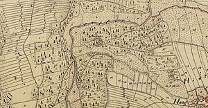
The castle site on an enlarged section of the Bavarian premiere (1808 to 1864) |
||
| Alternative name (s): | skyscraper | |
| Creation time : | Late medieval | |
| Castle type : | Höhenburg, spur location | |
| Conservation status: | Castle stable, double ditch and rampart preserved | |
| Place: | Hauzenberg - Hague | |
| Geographical location | 48 ° 37 '6.7 " N , 13 ° 35' 16.2" E | |
| Height: | 405 m above sea level NHN | |
|
|
||
The Burgstall Neuhaus , also known as a high-rise , is a late medieval hilltop castle near Haag , a district of the municipality of Hauzenberg in the Passau district in Bavaria .
No historical or archaeological information is known about this castle, the name Neuhaus appears on maps, in Haag there is a high-rise road that leads to the castle stables. It is roughly dated as late medieval , there are no known findings from the fortification. Only a double ditch with an intervening rampart has survived from the complex, the site is protected as a ground monument number D-2-7347-0009 "Castle stalls of the late Middle Ages (Neuhaus or Hochhaus)".
description
The castle site is 700 meters west-north-west of the Catholic parish church of St. Nikolaus von Haag over a river ford on a spur-like and west-north-west facing foothill of a plateau of the Bavarian Forest , which comes from the valley of the Staffelbach and from that of a small brook that comes from Haag into the Staffelbach flows, is formed. The valley of the Staffelbach runs on the north side of the Burgstall in a westerly direction, then turns to the south and also flows around the west side of the Burgstall. The south side is bounded by a deep indented valley of a nameless brook, which flows south to the Kaindlmühle shortly before the confluence . The castle complex was naturally well protected against approach on three sides, access was only possible on the slightly rising east side.
The castle site at around 405 m above sea level. NN height has an irregularly polygonal interior with a diameter of 30 meters. This inner surface is surrounded by a ring trench , the depth of which is still 2.5 meters. As an additional obstacle, the moat is preceded by a wall that merges into the slopes of the castle stable. This marginal wall shows interruptions of unclear timing in the northeast, west and southwest. On the most endangered side in the east of the fortification, the wall increases in thickness and thus protects the attack side of the castle. As a further obstacle to the approach, there is a second, curved ditch in front of the rampart in the east, which ends in the slope at both ends.
literature
- Johannes Pätzold: The prehistoric and early historical area monuments of Lower Bavaria . (Material booklets on Bavarian prehistory, series B, volume 2). Verlag Michael Laßleben , Kallmünz 1983, ISBN 3-7847-5090-7 , p. 263.
Web links
- Entry on Haag in the private database "Alle Burgen".
Individual evidence
- ↑ See cover picture
- ^ Bavarian State Office for Monument Preservation
- ↑ List of monuments for Hauzenberg (PDF) at the Bavarian State Office for Monument Preservation (PDF; 140 kB)
- ^ Location of the Burgstall in the Bavarian Monument Atlas
- ↑ Source description: Johannes Pätzold: The prehistoric and early historical terrain monuments of Lower Bavaria , p. 263


