
Burgstall near the Schenkenseen
| Burgstall near the Schenkenseen | ||
|---|---|---|
 Image 1: Burgstall near the Schenkenseen - view of the tower hill on the right edge of the picture |
||
| Alternative name (s): | possibly Neukottspiel Castle, later called Altkottspiel | |
| Creation time : | High Middle Ages | |
| Castle type : | Niederungsburg, Turmhügelburg (Motte) | |
| Conservation status: | Burgstall | |
| Standing position : | probably Ministeriale of the Ellwangen Monastery | |
| Place: | Frankenhardt -Markertshofen | |
| Geographical location | 49 ° 3 '43.9 " N , 9 ° 57' 27.5" E | |
| Height: | 428.4 m above sea level NN | |
|
||

The Postal at the taverns Lakes is the residue of a dialed , presumably high medieval motte (moth), the south-east of the hamlet Markertshofen in Baden-Württemberg Schwäbisch Hall district in the valley of taverns Bach was. To this day, nothing is certain about this small castle complex, neither who built it, nor who sat on it, or why it was destroyed.
history
To this day, no written reports can be related to this castle site with certainty; according to the way the castle was built, it can be dated to the 12th or 13th century. The name "Neukottspiel" for this castle comes from various land registers from the 14th century. This means that it would be directly related to the local nobility of Kottspiel and their Kottspiel moated castle (now also a castle stables ). But why they chose this remote place, which apparently was not touched by an old street , is not understandable. A section of the Ellwang wildbane border ran through the valley of the Schenkenbach, i.e. directly past the Burgstall. It is not known whether the castle can be assigned to this borderline. The older research had put forward the rather unlikely thesis that the original seat of the Lords of Kottspiel was there, which was renamed Altkottspiel after they had built a new castle (Neukottspiel) in Kottspiel.
The name of the castle was mentioned for the first time in 1419 in a fiefdom of the citizens of Hall , when Count Albrecht von Hohenlohe had moved in various goods, including the "purkstal called new kotspühel". Since the gentlemen of Kottspiel settled in Schwäbisch Hall at the end of the 14th century, it could have been their former goods. The forest was also called Neukottspiel in 1495, when it was sold by Kraft von Hohenlohe to the hospital in Schwäbisch Hall.
In 1522 a wood “the Meylandt Alt und Neu Kotspuhel” was mentioned, and later, in 1717, the Spitalwald was referred to as the “old Cothspühl”. Since there were also the names "Kotzbühel" for the castle hill and "Hallisch Spital Holtz der Alte Kotzbühl" for the surrounding forest on other maps from the 18th century, the name Neukottspiel seems to have gradually changed to Altkottspiel.
description
Today the Burgstall is located on the southern edge of the eastern, upper, of the two remaining Schenkenseen. These fish ponds, at that time there were four, were probably only created as fish ponds in the second half of the 16th century. On the valley side, the castle complex was naturally well protected by the swampy depression of the stream. Since the pond is located there today, nothing can be said about the fortifications on this side. Additional protection was only required on the remaining sides, especially on the south side raised by the Schiedberg.
Two trenches were dug on these sides . The outer, angled sole ditch begins to the west of the pond, strongly flattened, and is interrupted after about 17 meters by a forest path. It runs 94 meters in a south-easterly direction with a width of about 3 meters at the bottom and gradually narrows. From the outside, the trench is about 3 to 3.5 meters deep, to the inside about 2.5 meters, where an up to 1.2 meter high wall was placed on it. At the southernmost point of the trench, it is crossed again by a forest path that leads into the interior of the facility. The ditch then turns in a northerly direction and ends in the pond after about 60 meters. This moat surrounds a crescent-shaped area that slopes slightly to the north and was probably the place of the outer bailey . Traces of building are no longer to be seen there.
The second, inner moat surrounds the central castle hill in a roughly half-ring shape. The neck ditch hewn out of the reed sandstone (Fig. 2 and 3) ends in the pond on both sides (Fig. 4). Its outer, almost vertical embankment is about 7 meters high; it only rises 3 to 4 meters towards the castle hill.
The rectangular castle mound extends about 27 meters from north to south and was 20 meters wide. This area also slopes slightly to the north and ends at a 6 meter high slope into the pond (Fig. 1 and 4). Traces of development are no longer there either.

Photo 2: Western part of the neck ditch, left ascent to the outer bailey
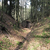
Photo 3: Southern part of the neck ditch, left ascent to the castle hill

Fig. 4: View of the castle hill and the western part of the inner moat


literature
- Alois Schneider: The castles in the Schwäbisch Hall district - an inventory . Konrad Theiss Verlag, Stuttgart 1995, ISBN 3-8062-1228-7 , pp. 95-97.
Web links
References and comments
- ↑ u. A. the fief book of the power of Hohenlohe
- ↑ Source history: Alois Schneider: The castles in the Schwäbisch Hall district - an inventory. P. 96ff.
- ↑ Between the two still existing ones there is a pierced dam over two meters high in the damp low forest.


Alt-Bartenstein Castle | Old castle | Altenhausen moated castle | Old castle | Amlishagen Castle | Anhausen Castle | Bachenstein Castle | Ruin Bachenstein | Bartenstein Castle | Bebenburg ruins | Burgstall near the Schenkenseen | Bernhardsweiler Castle | Bielriet Castle ruins | Billingsbach Castle | Braunsbach Castle | Brettheim Castle | Castle book | Buchhorn castle ruins | Burgstall Burgberg | Burleswagen Castle | Burgstall Burstel | Comburg | Crailsheim Castle | Crailsheim Castle | Döttingen Castle | Eichholz Castle | Ellrichshausen Castle | Eltershofen Castle | Enningen Castle | Erkenbrechtshausen Castle | Burgstall Eulenburg | Flügelau moated castle | Burgstall Forst | Flyhöhe Castle | Old Gaildorf Castle | Burgstall Gailenkirchen | Gammesfeld Castle | Burgstall Geißrain | Geyersburg castle ruins | Goldbach Castle | Burgstall Greifenberg | Gröningen Castle | Haagen Castle | Burgstall Haßfelden | Hengstfeld Castle | Herboldshausen moated castle | Herrentierbach Castle | Hertenstein Castle | Honhardt moated castle | Hohenkressberg Castle | Hohenstadt castle ruins | Hohenstatt Castle Stables | Hohenstein castle ruins | Burgstall Holenstein | Hopfach castle ruins | Hornberg Castle | Jagstheim Castle | Burgstall Kappelberg | Katzenstein Castle | Kirchberg Castle | Klingenfels castle ruins | Kottspiel moated castle | Kranzberg Castle | Langenburg Castle | Leofels Castle | Limpurg Castle | Lobenhausen Castle | Lohr Castle | Löwenburg | Ludwigsruhe Palace | Mainhardt Hunting Lodge | Matzenbach Castle | Burgstall Michelbach | Michelbach Castle an der Bilz | Michelbach Castle at the Gap | Tower Hill Michelbach | Molkenstein Castle | Morstein Castle | Neidenfels Castle | Neuberg Castle | Neuburg Castle | Obersontheim Castle | Oberrot Castle | Onolzheim Castle | Ottendorf Castle | Pfannenburg | Ramsbach moated castle | Rappenburg Castle | Rechenberg Castle | Reinsberg Castle | Reinsbürg Castle | Riedbach Castle | Rieden Castle | Burgstall gutters | Roßbürg Castle | Rötenberg Castle | Burgstall Sanzenbach | Burgstall Schäfferloch | Burgstall Schlossbuckel | Schmiedelfeld Castle | Schönebürg Castle | Schrozberg Castle | Schrozburg | Senftenschlössle Castle | Burgstall Staufenberg | Burgstall Stetten | Stöckenburg | Burgstall Streiflesberg | Suhlburg | Sulz Castle | Tannenburg | Tierberg Castle | Tullau Castle | Wasserburg Untermünkheim | Unterscheffach moated castle | Vellberg Castle | Vohenstein Castle | Wäldershub Castle | Werdeck castle ruins | Wildenstein Castle | Wolkenstein Castle | Burgstall Wüstenau