
Burlington County
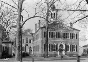 Burlington County Courthouse |
|
| administration | |
|---|---|
| US state : | New Jersey |
| Administrative headquarters : | Mount Holly Township |
| Address of the administrative headquarters: |
County Office Building 49 Rancocas Road, PO Box 6000 Mount Holly, NJ 08060-1388 |
| Foundation : | May 17, 1694 |
| Made up from: | West Jersey |
| Area code : | +1 609 or +1 856 |
| Demographics | |
| Residents : | 448,734 (2010) |
| Population density : | 215.3 inhabitants / km 2 |
| geography | |
| Total area : | 2122 km² |
| Water surface : | 38 km² |
| map | |
 |
|
| Website : www.co.burlington.nj.us | |
The Burlington County is a county in the US state of New Jersey . The county seat is Mount Holly Township .
The Burlington County is part of the Delaware Valley called metropolitan area around the city of Philadelphia .
geography
The county is located in the eastern suburbs of Philadelphia on the left bank of the Delaware River , which forms the border with Pennsylvania . Burlington County covers an area of 2,122 square kilometers, of which 38 square kilometers are water. It borders on the following counties:
|
Philadelphia, Pennsylvania , Bucks County, Pennsylvania |
Mercer County | Monmouth County |
| Camden County |
.svg)
|
Ocean County |
| Atlantic County |
history
Burlington County was formed as the original county on May 17, 1694. It was named after the old name of the town of Bridlington in England .
Historical objects
- In Mount Holly Township is the historic former prison building Burlington County Prison , which was built 1811th
In addition to the Burlington County Prison, three other places in the county have the status of a National Historic Landmark , the Francis Hopkinson House , the New St. Mary's Episcopal Church and Paulsdale . 95 buildings and sites in the county are registered in the National Register of Historic Places (as of February 16, 2018).
Demographic data
| growth of population | |||
|---|---|---|---|
| Census | Residents | ± in% | |
| 1790 | 18,095 | - | |
| 1800 | 21,521 | 18.9% | |
| 1810 | 24,979 | 16.1% | |
| 1820 | 28,822 | 15.4% | |
| 1830 | 31,107 | 7.9% | |
| 1840 | 32,831 | 5.5% | |
| 1850 | 43.203 | 31.6% | |
| 1860 | 49,730 | 15.1% | |
| 1870 | 53,639 | 7.9% | |
| 1880 | 55.402 | 3.3% | |
| 1890 | 58,528 | 5.6% | |
| 1900 | 58,241 | -0.5% | |
| 1910 | 66,565 | 14.3% | |
| 1920 | 81,770 | 22.8% | |
| 1930 | 93,541 | 14.4% | |
| 1940 | 97.013 | 3.7% | |
| 1950 | 135.910 | 40.1% | |
| 1960 | 224,499 | 65.2% | |
| 1970 | 323.132 | 43.9% | |
| 1980 | 362,542 | 12.2% | |
| 1990 | 395.066 | 9% | |
| 2000 | 423.394 | 7.2% | |
| 2010 | 448.734 | 6% | |
| Before 1900 1900–1990
2000 + 2010 |
|||
According to the 2010 census , Burlington County had 448,734 people in 264,100 households. The population density was 215.3 inhabitants per square kilometer.
The racial the population was composed of 73.8 percent white, 16.6 percent African American, 0.2 percent Native American, 4.3 percent Asian and other ethnic groups; 2.9 percent were descended from two or more races. Hispanic or Latino of any race was 6.4 percent of the population.
Statistically, 2.62 people lived in each of the 264,100 households.
23.2 percent of the population were under 18 years old, 62.9 percent were between 18 and 64 and 13.9 percent were 65 years or older. 50.9 percent of the population was female.
The median income for a household was 74,481 USD . The per capita income was $ 34,165. 6.1 percent of the population lived below the poverty line.
cities and communes
Townships
- Bass River Township
- Bordentown Township
- Burlington Township
- Chesterfield Township
- Cinnaminson Township
- Delanco Township
- Delran Township
- Eastampton Township
- Edgewater Park Township
- Evesham Township
- Florence Township
- Hainesport Township
- Lumberton Township
- Mansfield Township
- Maple Shade Township
- Medford Township
- Moorestown Township
- Mount Holly Township
- Mount Laurel Township
- New Hanover Township
- North Hanover Township
- Pemberton Township
- Riverside Township
- Shamong Township
- Southampton Township
- Springfield Township
- Tabernacle Township
- Washington Township
- Westampton Township
- Willingboro Township
- Woodland Township
Individual evidence
- ↑ GNIS-ID: 882272. Retrieved on February 22, 2011 (English).
- ^ National Association of Counties.Retrieved October 26, 2011
- ↑ Listing of National Historic Landmarks by State: New Jersey . National Park Service , accessed February 16, 2018.
- ↑ Search mask database in the National Register Information System. National Park Service , accessed February 16, 2018.
- ^ US Census Bureau _ Census of Population and Housing.Retrieved February 28, 2011
- ^ Extract from Census.gov.Retrieved February 28, 2011
- ↑ Extract from census.gov (2000 + 2010) Retrieved April 13, 2012
- ^ US Census Bureau, State & County QuickFacts - Burlington County. Retrieved October 26, 2011
Web links
- Official website
- US Census Bureau, State & County QuickFacts - Burlington County
- Yahoo Image Search - Burlington County
- www.city-data.com - Burlington County
Coordinates: 39 ° 53 ′ N , 74 ° 40 ′ W