Kranowitz
| Kranowitz Krzanowice |
||
|---|---|---|

|
|
|
| Basic data | ||
| State : | Poland | |
| Voivodeship : | Silesia | |
| Powiat : | Racibórz | |
| Area : | 3.19 km² | |
| Geographic location : | 50 ° 1 ' N , 18 ° 7' E | |
| Height : | 220 m npm | |
| Residents : | 2157 (Jun. 30, 2019) |
|
| Postal code : | 47-470 | |
| Telephone code : | (+48) 32 | |
| License plate : | SRC | |
| Economy and Transport | ||
| Street : | Racibórz - Opava | |
| Next international airport : | Katowice Airport | |
| Gmina | ||
| Gminatype: | Urban and rural municipality | |
| Gmina structure: | 5 localities | |
| 4 school offices | ||
| Surface: | 47.06 km² | |
| Residents: | 5739 (June 30, 2019) |
|
| Population density : | 122 inhabitants / km² | |
| Community number ( GUS ): | 2411033 | |
| Administration (as of 2015) | ||
| Mayor : | Andrzej Strzedulla | |
| Address: | ul. 15 Grudnia 5 47-470 Krzanowice |
|
| Website : | www.krzanowice.pl | |
Kranowitz (Polish Krzanowice [ kʃanɔ'vʲiʦɛ ], Czech Křenovice , also Chřenovice ; 1936–1945 Kranstädt ) is a town in the Powiat Raciborski in the Silesian Voivodeship in Poland. It is the seat of an urban and rural municipality of the same name .
geography
Kranowitz is located ten kilometers southwest of Racibórz on the Leobschützer Lößhügelland ( Płaskowyż Głubczycki ) on the Bilawoda . Neighboring places are Samborowice ( Schammerwitz ) in the north, Woinowitz and Bieńkowice ( Benkowitz ) in the northeast, Bolesław ( Boleslau ; 1936–1945 Bunzelberg ) in the east, Borutin in the southeast and Klein Peterwitz in the northwest. Across the border with the Czech Republic , which runs south and west, are Chuchelná in the south, Strahovice ( Strandorf ) and Rohov ( Rohow ) in the south-west and Sudice in the west.
history
The village "Cranewicz" has belonged to Moravia since it was founded . With the approval of King Ottokar II. Přemysl , Herbort von Fülme , a stewardess of Olomouc Bishop Bruno von Schauenburg , elevated it to the status of a town in 1265 and implemented it according to Leobschützer law. In 1269 Kranowitz was incorporated into the Duchy of Opava , which was newly created from the then province of Opava for Nicholas I , an illegitimate son of King Ottokar II. Přemysl. The St. Wenceslas Church is documented for 1302, and in 1313 King John of Bohemia confirmed the town charter.
Its location on the trade route from Racibórz to Opava was conducive to development in the centuries that followed. Various artisans settled here and beer was brewed. The owners of the town, which lost its importance in the 17th century, changed frequently.
After the First Silesian War , Kranowitz and most of Silesia fell to Prussia in 1742 . It sank to a market town and initially belonged to the Leobschützer district. After the reorganization of Prussia, it was incorporated into the Ratibor district in 1818 . The authorities now carried out an organizational division between the market town of Kranowitz and the village of the same name. In 1784 the market town consisted of 472 inhabitants, while 666 people lived in the village of Kranowitz. After efforts to regain city rights failed in the 1870s, the town was united with the village.
In 1891 the construction of a railway between Ratibor and Troppau, won by Prince Karl Max Lichnowsky , began, on which the first train ran on October 20, 1895. On October 24, 1919 there was a railway accident in Kranowitz , in which, according to contradicting reports, between 34 and 60 people died when the passenger train coming from Kuchelna drove into a freight locomotive and a barrel of smuggled alcohol exploded.
Although Kranowitz was mostly Moravian-speaking, it remained with the German Empire in 1920, in contrast to neighboring Zauditz , which was annexed to Czechoslovakia . In the referendum in Upper Silesia in 1921 on further state membership in Kranowitz, 2,134 votes (96.9%) were cast in favor of remaining with Germany and 69 (3.1%) in favor of joining Poland - Kranowitz remained with Germany.
In 1936 the National Socialists renamed the city Kranstädt . In 1939 it consisted of 3872 inhabitants. After the Red Army marched in and handed over to the Polish administration, it was given the Polish name of Krzanowice in 1945 . Since only a part of the ancestral residents had fled or were expelled, a German minority was able to survive in the area. In 2001 the city rights were renewed. According to the census of 2002, 20.64% of the community population belonged to the German minority , another 7.10% described themselves as "Silesians". This makes Kranowitz the only municipality in the Silesian Voivodeship with a minority share of over 20 percent. Despite its authorization, the municipality has not yet approved German as an auxiliary language , but introduced bilingual place names in 2008 . The cross-border rail link is now closed. In November 2012, the bilingual place-name signs were finally put up in the community. This makes it the first municipality in the Silesian Voivodeship in which all places have bilingual place-name signs.
Part of the population still speaks a dialect that is very similar to Moravian .
owner
- Johannes Herbord von Füllstein (until 1300)
- Eckerich Herbord von Füllstein (after 1313)
Population development
Kranowitz's population:
|
|
Partner municipality
- Salzbergen (Germany), since May 2006
Attractions
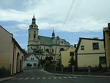
- The Catholic parish church of St. Wenceslas (Kościół św. Wacława) on the former castle hill was first mentioned in 1302 and after several renovations was built in 1742 in the Baroque style. After a fire in 1813, a new building was built in 1915 in the neo-baroque style based on a design by the architect Joseph Seyfried. The cruciform floor plan of the burned down church with a baroque front tower and roof turret was taken up again; However, with a length of 48 meters, a width of 35 meters and a 56-meter high church tower, it is significantly larger than the previous building. The dome and interior were painted by Hans Martin. The main altar, whose painting depicts St. Wenceslas is flanked by two baroque figures from the 18th century.
- Three bells of the church were cast in 1958, the old urban bell survived the Second World War: St. Hedwig (fis; 750 kg), St. Urban (cis; 400 kg), St. Franziskus (cis, 215 kg) as well as St. Ignaz (fis, 76 kg).
- The Nikolauskirche ( Kościół św. Mikołaja ) in the northeast of the city was built in 1744 in the late Baroque style in place of a chapel and provided with a roof turret. After cracks appeared in the vault as early as 1762, it was replaced by a wooden one in 1802 during an extensive renovation. The interior furnishings (altar leaves on the side altars, the Way of the Cross and some statues) date largely from the 18th century.
local community
In addition to the main town of the same name, the districts belong to the urban and rural community of Kranowitz
- Bojanow (Bojanów ; 1936–1945 Kriegsbach )
- Borutin (Borucin ; 1936–1945 Streitkirch )
- Klein Peterwitz (Pietraszyn)
- Woinowitz (Wojnowice ; 1936–1945 Weihendorf )
Personalities
- Vincenz Kollar (1797–1860), Austrian zoologist and entomologist
- Albrecht von Krenowitz († 1353 or later), Burgrave of Glatz as well as captain and pledge holder of the Glatzer country
- Max Schirschin (1921–2013), German soccer player and soccer coach
- Johannes Slawik (1892 – after 1945), German agricultural administrator and politician
- Ernst Schmack (1918–1984), German school teacher and didactician
- Anna Bocson (born Wojtaszek; * 1936), Polish-Australian javelin thrower
literature
- Hugo Weczerka (Hrsg.): Handbook of the historical places . Volume: Silesia (= Kröner's pocket edition . Volume 316). Kröner, Stuttgart 1977, ISBN 3-520-31601-3 , p. 246.
- Paweł J. Newerla, Wiesław Siwik: Outline of the history of Kranstädt (Zarys historii Krzanowic) . Dr. Antykwa, Krzanowice 1996, ISBN 83-904855-1-6 .
Web links
- Literature by and about Kranowitz in the catalog of the German National Library
- City website .
Individual evidence
- ↑ a b population. Size and Structure by Territorial Division. As of June 30, 2019. Główny Urząd Statystyczny (GUS) (PDF files; 0.99 MiB), accessed December 24, 2019 .
- ^ City website, Władze Miejskie , accessed on February 16, 2015
- ↑ See results of the referendum ; down. on October 11, 2009
- ↑ See Polish Main Statistical Office (GUS) ( Memento from December 17, 2012 in the Internet Archive )
- ↑ Internet portal of Germans in Poland: The place-name signs are up! Kranowitz community in bilingual place name signs! ( Memento of March 5, 2016 in the Internet Archive ); from November 22, 2012
- ↑ Sources of the population figures : 1822: [1] - 1830: [2] - 1844: [3] - 1855, 1861: [4] - 1910: [5] - 1933, 1939: [6]


