Chesapeake Bay
| Chesapeake Bay | ||
|---|---|---|
|
Satellite photo of the Chesapeake Bay |
||
| Waters | Atlantic Ocean | |
| Land mass | North America , Delmarva Peninsula | |
| Geographical location | 37 ° 15 ′ N , 76 ° 7 ′ W | |
|
|
||
| length | 311 km | |
| surface | 12,000 km² | |
| Tributaries | Potomac River , Susquehanna River , James River | |
|
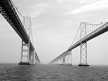
The Chesapeake Bay Bridge |
||
The Chesapeake Bay is the largest estuary in the United States . It is a bay running south to the Atlantic Ocean between the Delmarva Peninsula in the east and the North American mainland in the west and surrounded by the states of Virginia and Maryland , for which it is one of the most important natural landscapes.
The name Chesepiooc meant in the Algonquin language of the Powhatan and Nanticoke Indian tribes , who were resident here, probably "Great River" or perhaps referred to a village at the mouth of the water to the open sea. In 1607, English colonists established the Jamestown colony in the James River , which became England's first successful colony in North America. Its leader, John Smith, was the first European to explore parts of the bay and its southern tributaries in 1608.
location
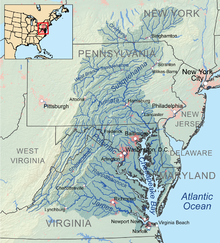
The bay borders the US states of Virginia and Maryland and covers an area of 12,000 km². Its catchment area covers a total of 165,800 km²; It includes parts of six American states - in addition to Virginia and Maryland, New York , Pennsylvania , Delaware and West Virginia - as well as the entire District of Columbia . More than 150 rivers and streams flow into the body of water, which extends 311 km from the Susquehanna River in the north to the open Atlantic Ocean. From a river history point of view, the bay is the old lower valley of the Susquehanna, in which it had dug itself 15,000 years ago during the last glacial period , when the sea level was about 100 m below today's level.
At its narrowest point east of Annapolis, Maryland , the bay is only four miles wide; it is spanned there by the Chesapeake Bay Bridge . Near the mouth, the Chesapeake Bay Bridge-Tunnel connects the two sides.
Climate and the effects of climate change
According to the effective climate classification , the climate of the Chesapeake Bay can be described as an east side climate : There are hot, humid summers, cool winters and year-round rainfall. Here the spring and summer temperatures are a little more moderate than in the interior, such as Washington, DC
The effects of climate change have been reviewed by Hino et al. (2019) examined as an example for the city of Annapolis : Due to the overheating of the earth's climate system, the number of tidal flood events in Annapolis increases over time. In 2017 alone, Annapolis recorded 63 such events. The economic damage is considerable. The passage of seawater over the coastal fortifications in the year mentioned cost owners of shops, cafés or restaurants between 86,000 and 172,000 US dollars per shop due to the lack of customers.
The crater
In the Eocene 35 million years ago, a meteorite hit the entrance to the bay today ; the center of the resulting 85 km wide and 1.3 km deep impact crater is eight kilometers west of Cape Charles ; the structure was only discovered in 1993 during oil drilling because of its submarine location. The crater is filled with breccias , which over time were covered by a 300 to 500 meter thick layer of sediment . The disintegration leading to the formation of the breccias also influenced the natural aquifer and is responsible for the fact that the salinity of the groundwater here is 1.5 times higher than elsewhere. For the most part, the groundwater is too brackish for drinking water purposes, which of course the inhabitants of the affected areas were aware of; only the discovery of the crater brought the explanation of the facts.
The first indications of the impact were a borehole in distant Atlantic City , in which a 20 cm thick layer of ejecta was found, signs of a massive impact. Despite its great age, it is most likely one of the reasons for the formation of today's bay.
Characteristic
Over long distances which forms the banks as cliffs were, the fall line from the upper Piedmont - Plateau to the actual coastal plain. The largest cities and ports are located near the bank in the west: Annapolis , Baltimore , Washington, DC and the agglomeration around Hampton Roads . On the rugged eastern shore there are only small towns, fishing villages or small towns in the Marina yachts alongside the boats bob up and down the fishermen. On the adjoining Delmarva peninsula , which is largely under nature protection , extensive marshlands , swamps , forests and pastures emerged.
The marshes are regularly by the tides flooded, their grasses are against the salt water resistant . This peculiar landscape offers a nutrient-rich shelter and habitat for various bird species ( blue heron , bald eagle , osprey , Canadian wild geese , storks , tundra swans and many migratory birds on the way to the Caribbean ), for fish ( flounders , perches , alsens , minnows ) and for Crabs and oysters .
Estuary rivers
- Susquehanna River
- Patapsco River
- Potomac River
- James River
- Appomattox River
- Rappahannock River
- Patuxent River
- Choptank River
- York River with the Pamunkey River and Mattaponi River
Ecology and fishing
The bay has long been famous for its rich fishing grounds, especially seafood such as crabs , clams, and oysters . Also diamond turtles that were like made into soup and stews, they began here in large numbers.
The writer and satirist Henry L. Mencken from Baltimore called the Chesapeake Bay a "natural protein factory " in the early 20th century . In that era, the American oyster ( Crassostrea virginia ) flourished so numerous that the nautical charts noted the oyster beds as dangerous obstacles in the shipping waters, which were often only two to six meters deep. At the zenith of the oyster catch in the middle of the 19th century, 7,000 fishermen lived on it .
Since then, overfishing for over a hundred years, over-fertilization by agriculture (especially on the east coast) and environmental pollution in the course of urbanization (especially on the west coast of the bay) have significantly declined the stocks. In the so-called Chesapeake Bay Agreement of 1987, the riparian states agreed on higher guide values for their conservation in this estuary, which is still the most shellfish-rich estuary in the USA.
Every year 45,000 tons of crab meat are fished here, which makes the USA the largest crab meat exporter in the world as before; However, the previous inventory figures are still a long way off, so the agreement was not particularly successful.
The former governor of Maryland , Robert Ehrlich , won the election in 2003 with the promise to develop environmental protection on the Chesapeake Bay.
In 2014, a coalition of administrations related to the bay agreed on a program for coordinated environmental protection throughout the bay. Participants are the governors of Maryland, Virginia, Pennsylvania, New York, West Virginia, and Delaware, the mayors of Washington, DC; the chairman of the Chesapeake Bay Commission and the US Environmental Protection Agency (EPA). The program focuses on direct measures for water pollution control and changes in land use in order to reduce water pollution, but also on social issues such as environmental education among the population.
Others
The bay was the site of the Battle of Chesapeake Bay in 1781 . The French fleet defeated the Royal Navy at the time , so that the land troops of British General Charles Cornwallis received no support. In the end, therefore, the USA was able to enforce its independence from Great Britain .
The Chesapeake Bay Retriever dog breed is native to the area .
The novel "The Bay" (orig. "Chesapeake") by James A. Michener (1978) describes family stories and historical events from 1583 to 1978.
literature
- Christine Keiner: The Oyster Question: Scientists, Watermen, and the Maryland Chesapeake Bay Since 1880. University of Georgia Press, Athens 2009, ISBN 978-0-8203-2698-6 .
- Tom Horton: Bay Country. Johns Hopkins University Press, Baltimore 1994, ISBN 978-0-8018-4875-9 .
- Travel report of Mr. Hofrath Weber, who was shipped over to America (from Chesapeak Bai, June 12, 1834 and Baltimore, June 21, 1834). In: The Wanderer on the Rheine and on the Moselle No. 9 from August 23, 1834 and No. 10 from August 30, 1834 (online edition dilibri Rhineland-Palatinate).
Web links
Individual evidence
- ↑ Washington Post article “A Dead Indian Language Is Brought Back to Life,” December 12, 2006.
- ↑ Miyuki Hino, Samanthe Tiver Belanger, Christopher B. Field, Alexander R. Davies, Katharine J. Mach (2019): High-tide flooding disrupts local economic activity. Science Advances. Vol. 5, no.2, eaau2736. https://doi.org/10.1126/sciadv.aau2736
- ^ Richard J. Dent: Chesapeake prehistory old traditions, new directions, New York: Plenum Press 1995, p. 1, ISBN 0-306-45028-3
- ↑ Chesapeake Executive Council: Chesapeake Executive Council signs landmark accord to restore Bay watershed , June 16, 2014


