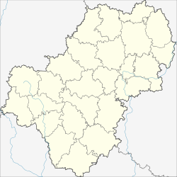
Chvastovichi
| Village
Chwastowitschi
Хвастовичи
|
||||||||||||||||||||||||||||||||
|
||||||||||||||||||||||||||||||||
|
||||||||||||||||||||||||||||||||
Chwastowitschi ( Russian Хвасто́вичи ) is a village (selo) in the Kaluga Oblast in Russia with 4509 inhabitants (as of October 14, 2010).
geography
The place is about 140 km as the crow flies south-south-west of the Kaluga Oblast Administrative Center on the Velja river, which flows 7 km south-east into the Resseta , which flows off via the Schisdra to the Oka .
Chwastowitschi is the administrative center of the Chwastowitschski Rajons and the seat of the rural community (selskoje posselenije) Selo Chwastowitschi, which also includes the small settlement (possjolok) Uspenski , 3 km south of the town center .
history
The founding year of the place is 1494, when it was first mentioned in a document of Prince Worotynski, one of the rulers of the principalities on the Upper Oka . According to other sources, a place called Chwostowicze in the Principality of Karachev is already mentioned in Polish sources, which refer to the first half of the 14th century. From this period the area belonged to the Grand Duchy of Lithuania . In the course of the Russo-Lithuanian wars , the place came to the short-lived Principality of Kaluga in 1505 , and in 1518 to the Grand Duchy of Moscow . In the time of the chaos (Smuta) around 1600 it belonged again to Poland-Lithuania before it finally came into Russian possession.
In 1708 Chwastowitschi was assigned to the Ujesd Koselsk of the Moscow Governorate , from 1719 as part of the Kaluga Province, and in 1777 after various administrative changes to the newly created Ujesd Schisdra . This initially belonged to the governorship of Kaluga, from 1796 to the governorate of Kaluga . In documents from this period the place is referred to as Fostowitschi , later until the early 20th century as Chwostowitschi. Economically significant and relatively populous, the village became in the 19th century the center of a Wolost (Milejewskaja wolost) named after the 7 km northeastern village of Milejewo .
From the Volost and parts of the surrounding area a Rajon named after the place was formed on July 12, 1929, with its seat in Chwastowitschi. During World War II , the village was occupied by the German Wehrmacht on October 7, 1941 and recaptured by the Red Army on August 15, 1943 as part of their Oryol Operation (also known as Operation Kutuzov ).
From the beginning of 1963 to the beginning of 1965 the Rajon was temporarily dissolved and its territory was annexed to the northwestern neighboring Schisdrinski rajon.
Population development
| year | Residents |
|---|---|
| 1897 | 2140 |
| 1939 | 2900 |
| 1959 | 3251 |
| 1970 | 3547 |
| 1979 | 4097 |
| 1989 | 4485 |
| 2002 | 4596 |
| 2010 | 4509 |
Note: census data
traffic
Chwastowitschi is located on the 29N-144, which begins about 30 km northwest on the federal trunk road M3 Ukraina from Moscow via Bryansk to the Ukrainian border and continues to the village of Tereben , 12 km east-southeast . From Chwastowitschi in a westerly direction the 29N-149 also leads to the M3, to the northeast the 29K-016 past the neighboring district center of Uljanowo to Koselsk.
The nearest train station is 25 km northwest of Sudimir on the main Moscow - Bryansk - Kiev route . In Tereben there was a station on the branch line from Brjansk ( Polpinskaya station ) to Dudorowski ( Dudorowo station ) built in the 1920s to 1930s . However, this was shut down in sections until 2010 and then completely dismantled.
Web links
Individual evidence
- ↑ a b Itogi Vserossijskoj perepisi naselenija 2010 goda. Tom 1. Čislennostʹ i razmeščenie naselenija (Results of the All-Russian Census 2010. Volume 1. Number and distribution of the population). Tables 5 , pp. 12-209; 11 , pp. 312–979 (download from the website of the Federal Service for State Statistics of the Russian Federation)

