Dill (river)
| dill | ||
|
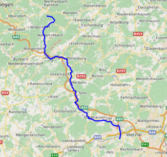
Course of the dill |
||
| Data | ||
| Water code | EN : 2584 | |
| location |
Rothaar Mountains
West Hessian mountain and valley land |
|
| River system | Rhine | |
| Drain over | Lahn → Rhine → North Sea | |
| source | at Haiger - Offdilln 50 ° 50 ′ 29 ″ N , 8 ° 13 ′ 1 ″ E |
|
| Source height | approx. 567 m above sea level NHN | |
| muzzle | in Wetzlar in the Lahn coordinates: 50 ° 33 ′ 3 ″ N , 8 ° 29 ′ 17 ″ E 50 ° 33 ′ 3 ″ N , 8 ° 29 ′ 17 ″ E |
|
| Mouth height | 147 m above sea level NHN | |
| Height difference | approx. 420 m | |
| Bottom slope | approx. 7.6 ‰ | |
| length | 55 km | |
| Catchment area | 717.357 km² | |
| Outflow A Eo : 717.357 km² at the mouth |
MNQ MQ Mq |
1.137 m³ / s 9.514 m³ / s 13.3 l / (s km²) |
| Medium-sized cities | Dillenburg , Herborn , Wetzlar | |
|
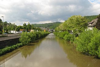
The Dill in Dillenburg, looking upstream, in the background the Untertor |
||
|
The source of the dill |
||
The Dill is a 55 km long, northern and orographically right tributary of the Lahn in the central Hessian Lahn-Dill district , Germany .
geography
source
The Dill rises about 1.8 km northwest of Offdilln on the southeast slope of the Haincher Höhe at an altitude of 567 m above sea level. NHN . It has only a very small water catchment area, as it rises high on the ridge-like Rothaar ridge. This is also the reason for the small amount of pouring. The dill spring is generously set in a wall made of sandstone, and next to the spring a stone with the inscription 'Dill-Quelle' is set into the ground. The dill source is probably a layer source .
course
The Dill flows through the Lahn-Dill district, which is named after it, via Dillenburg and Herborn in a southerly direction. After 55 km it flows into 147 m above sea level. NHN in Wetzlar in the Lahn. The difference in height of 420 m that has been overcome corresponds to an average bed gradient of 7.6 ‰.
The dill has given its name to many places in its course; so there are the places Offdilln , Dillbrecht and Fellerdilln on the upper reaches . Rodenbach is the crossing point where the Roßbach joins the Dill and turns past the town of Haiger towards Dillenburg; The latter was the county seat of the former Dill district and the former residence of the House of Nassau-Orange . The further course of the Dill leads via Herborn and Ehringshausen (with the district of Dillheim named after the river ) to Wetzlar, where it flows into the Lahn.
Tributaries
The Dill, the second longest and with 9513.9 l / s the richest tributary of the Lahn, flows into numerous, sometimes very short tributaries. The longest tributary is the Dietzhölze with a length of 23.8 km. However , with 148.756 km² the Aar has a much larger catchment area and a slightly larger average flow rate.
In the following, the larger tributaries are named with the orographic position and height of the mouth, the length of the river, the size of the catchment area, the annual average discharge and the river code. The order of naming is from the source to the mouth.
(For a better overview or for sorting downstream, hyphens are inserted in the DGKZ numbers after 2584 - dill !)
| Surname |
location |
Length [km] |
Catchment area [km²] |
Discharge (MQ) [l / s] |
Mouth height [m. ü. NHN] |
DGKZ |
|---|---|---|---|---|---|---|
| Ortsbach * | Left | 1.6 | 1.5 | 399 | 2584-11192 | |
| Rossbach | Left | 10.1 | 21,970 | 391.6 | 286 | 2584-12 |
| Treisbach | right | 4.7 | 13,134 | 201.1 | 274 | 2584-14 |
| Haigerbach ( Ketzerbach ) | right | 15.5 | 52.009 | 1013.7 | 262 | 2584-2 |
| Aubach | right | 15.8 | 31,322 | 620.3 | 262 | 2584-32 |
| Hengstbach | Left | 4.5 | 8.525 | 99.1 | 242 | 2584-34 |
| Dietzhölze | Left | 23.8 | 88.440 | 1431.4 | 235 | 2584-4 |
| Nanzenbach | Left | 10.8 | 11,510 | 146.4 | 226 | 2584-54 |
| Scheldt | Left | 12.0 | 35.028 | 425.9 | 221 | 2584-56 |
| Aar | Left | 20.6 | 148.756 | 1602.2 | 210 | 2584-6 |
| Amdorfbach | right | 15.9 | 54.371 | 781.5 | 210 | 2584-72 |
| Rehbach | right | 20.3 | 48.659 | 828.3 | 196 | 2584-8 |
| Stippbach | Left | 6.2 | 5.501 | 48.6 | 190 | 2584-912 |
| Lemp | Left | 11.7 | 34.966 | 274.3 | 170 | 2584-92 |
| Mühlbach | right | 3.1 | 5.810 | 49.3 | 170 | 2584-94 |
| Bechlinger Bach | Left | 6.5 | 9,874 | 81.0 | 163 | 2584-96 |
| Bombach * | Left | 6.3 | 6.2 | 159 | 2584-9712 | |
| Blasbach | Left | 7.7 | 15,560 | 114.7 | 152 | 2584-98 |
(*: Catchment area roughly estimated)
River length
The length of the dill is often given as 68 km, for example in the Meyers Konversationslexikon from 1885 to 1892 as well as in numerous newer encyclopedias. However, this is an incorrect statement, as can be understood from the stationing points of the Hessian State Office for Environment and Geology .
traffic
Important traffic arteries run parallel to the Dilltal, including the BAB 45 , the federal road 277 and the Dill line of the railway.
Individual evidence
- ↑ a b c d e Topographic map 1: 25,000
- ↑ a b c d e f Water map service of the Hessian Ministry for the Environment, Climate Protection, Agriculture and Consumer Protection ( information )
- ↑ See old profile
- ↑ Water directory of the State Office for Nature, Environment and Consumer Protection NRW 2010 (XLS; 4.67 MB) ( Notes )
- ↑ Meyers Konversationslexikon from 1885 to 1892
Web links
- Level at Aßlar on the HLUG side
- Level near Dillenburg on the HLUG side
- Level at Haiger on the HLUG side
- Hessian State Office for Environment and Geology: Retention cadastre, river area Dill - river area code number: 2584 (PDF; 126 kB) ( Notes )
- Water profile and program of measures 2584.2 ( Memento from January 1, 2013 in the web archive archive.today ) ( Notes ) → Overview of all Hessian river systems (PDF, 1.7 MB) Obere Dill
- Water profile and program of measures 2584.1 ( Memento from January 1, 2013 in the web archive archive.today ) ( Notes ) → Overview of all Hessian river systems (PDF, 1.7 MB) Untere Dill
- Profile Dill ( Memento from February 11, 2013 in the web archive archive.today ) (old profile with discharge data)


