
Federal motorway 45
| Bundesautobahn 45 in Germany | |||||||||||||||||||||||||||||||||||||||||||||||||||||||||||||||||||||||||||||||||||||||||||||||||||||||||||||||||||||||||||||||||||||||||||||||||||||||||||||||||||||||||||||||||||||||||||||||||||||||||||||||||||||||||||||||||||||||||||||||||||||||||||||||||||||||||||||||||||||||||||||||||||||||||||||||||||||||||||||||||||||||||||||||||||||||||||||||||||||||||||||||||||||||||||||||||||||||||||||||||||||||||||||||||||||||||||||||||||||||||||||||||||||||||||||||||||||||||||||||||||||||||||||||||||||||||||||||||||||||||||||||||||||||||||||||||||||||||||||||||||||||||||||||||||||||

|
|||||||||||||||||||||||||||||||||||||||||||||||||||||||||||||||||||||||||||||||||||||||||||||||||||||||||||||||||||||||||||||||||||||||||||||||||||||||||||||||||||||||||||||||||||||||||||||||||||||||||||||||||||||||||||||||||||||||||||||||||||||||||||||||||||||||||||||||||||||||||||||||||||||||||||||||||||||||||||||||||||||||||||||||||||||||||||||||||||||||||||||||||||||||||||||||||||||||||||||||||||||||||||||||||||||||||||||||||||||||||||||||||||||||||||||||||||||||||||||||||||||||||||||||||||||||||||||||||||||||||||||||||||||||||||||||||||||||||||||||||||||||||||||||||||||||
| |
|||||||||||||||||||||||||||||||||||||||||||||||||||||||||||||||||||||||||||||||||||||||||||||||||||||||||||||||||||||||||||||||||||||||||||||||||||||||||||||||||||||||||||||||||||||||||||||||||||||||||||||||||||||||||||||||||||||||||||||||||||||||||||||||||||||||||||||||||||||||||||||||||||||||||||||||||||||||||||||||||||||||||||||||||||||||||||||||||||||||||||||||||||||||||||||||||||||||||||||||||||||||||||||||||||||||||||||||||||||||||||||||||||||||||||||||||||||||||||||||||||||||||||||||||||||||||||||||||||||||||||||||||||||||||||||||||||||||||||||||||||||||||||||||||||||||
| map | |||||||||||||||||||||||||||||||||||||||||||||||||||||||||||||||||||||||||||||||||||||||||||||||||||||||||||||||||||||||||||||||||||||||||||||||||||||||||||||||||||||||||||||||||||||||||||||||||||||||||||||||||||||||||||||||||||||||||||||||||||||||||||||||||||||||||||||||||||||||||||||||||||||||||||||||||||||||||||||||||||||||||||||||||||||||||||||||||||||||||||||||||||||||||||||||||||||||||||||||||||||||||||||||||||||||||||||||||||||||||||||||||||||||||||||||||||||||||||||||||||||||||||||||||||||||||||||||||||||||||||||||||||||||||||||||||||||||||||||||||||||||||||||||||||||||
 |
|||||||||||||||||||||||||||||||||||||||||||||||||||||||||||||||||||||||||||||||||||||||||||||||||||||||||||||||||||||||||||||||||||||||||||||||||||||||||||||||||||||||||||||||||||||||||||||||||||||||||||||||||||||||||||||||||||||||||||||||||||||||||||||||||||||||||||||||||||||||||||||||||||||||||||||||||||||||||||||||||||||||||||||||||||||||||||||||||||||||||||||||||||||||||||||||||||||||||||||||||||||||||||||||||||||||||||||||||||||||||||||||||||||||||||||||||||||||||||||||||||||||||||||||||||||||||||||||||||||||||||||||||||||||||||||||||||||||||||||||||||||||||||||||||||||||
| Basic data | |||||||||||||||||||||||||||||||||||||||||||||||||||||||||||||||||||||||||||||||||||||||||||||||||||||||||||||||||||||||||||||||||||||||||||||||||||||||||||||||||||||||||||||||||||||||||||||||||||||||||||||||||||||||||||||||||||||||||||||||||||||||||||||||||||||||||||||||||||||||||||||||||||||||||||||||||||||||||||||||||||||||||||||||||||||||||||||||||||||||||||||||||||||||||||||||||||||||||||||||||||||||||||||||||||||||||||||||||||||||||||||||||||||||||||||||||||||||||||||||||||||||||||||||||||||||||||||||||||||||||||||||||||||||||||||||||||||||||||||||||||||||||||||||||||||||
| Operator: |
|
||||||||||||||||||||||||||||||||||||||||||||||||||||||||||||||||||||||||||||||||||||||||||||||||||||||||||||||||||||||||||||||||||||||||||||||||||||||||||||||||||||||||||||||||||||||||||||||||||||||||||||||||||||||||||||||||||||||||||||||||||||||||||||||||||||||||||||||||||||||||||||||||||||||||||||||||||||||||||||||||||||||||||||||||||||||||||||||||||||||||||||||||||||||||||||||||||||||||||||||||||||||||||||||||||||||||||||||||||||||||||||||||||||||||||||||||||||||||||||||||||||||||||||||||||||||||||||||||||||||||||||||||||||||||||||||||||||||||||||||||||||||||||||||||||||||
| Start of the street: | Castrop-Rauxel | ||||||||||||||||||||||||||||||||||||||||||||||||||||||||||||||||||||||||||||||||||||||||||||||||||||||||||||||||||||||||||||||||||||||||||||||||||||||||||||||||||||||||||||||||||||||||||||||||||||||||||||||||||||||||||||||||||||||||||||||||||||||||||||||||||||||||||||||||||||||||||||||||||||||||||||||||||||||||||||||||||||||||||||||||||||||||||||||||||||||||||||||||||||||||||||||||||||||||||||||||||||||||||||||||||||||||||||||||||||||||||||||||||||||||||||||||||||||||||||||||||||||||||||||||||||||||||||||||||||||||||||||||||||||||||||||||||||||||||||||||||||||||||||||||||||||
| End of street: | Stockstadt am Main | ||||||||||||||||||||||||||||||||||||||||||||||||||||||||||||||||||||||||||||||||||||||||||||||||||||||||||||||||||||||||||||||||||||||||||||||||||||||||||||||||||||||||||||||||||||||||||||||||||||||||||||||||||||||||||||||||||||||||||||||||||||||||||||||||||||||||||||||||||||||||||||||||||||||||||||||||||||||||||||||||||||||||||||||||||||||||||||||||||||||||||||||||||||||||||||||||||||||||||||||||||||||||||||||||||||||||||||||||||||||||||||||||||||||||||||||||||||||||||||||||||||||||||||||||||||||||||||||||||||||||||||||||||||||||||||||||||||||||||||||||||||||||||||||||||||||
| Overall length: | 257 km | ||||||||||||||||||||||||||||||||||||||||||||||||||||||||||||||||||||||||||||||||||||||||||||||||||||||||||||||||||||||||||||||||||||||||||||||||||||||||||||||||||||||||||||||||||||||||||||||||||||||||||||||||||||||||||||||||||||||||||||||||||||||||||||||||||||||||||||||||||||||||||||||||||||||||||||||||||||||||||||||||||||||||||||||||||||||||||||||||||||||||||||||||||||||||||||||||||||||||||||||||||||||||||||||||||||||||||||||||||||||||||||||||||||||||||||||||||||||||||||||||||||||||||||||||||||||||||||||||||||||||||||||||||||||||||||||||||||||||||||||||||||||||||||||||||||||
|
State : |
|||||||||||||||||||||||||||||||||||||||||||||||||||||||||||||||||||||||||||||||||||||||||||||||||||||||||||||||||||||||||||||||||||||||||||||||||||||||||||||||||||||||||||||||||||||||||||||||||||||||||||||||||||||||||||||||||||||||||||||||||||||||||||||||||||||||||||||||||||||||||||||||||||||||||||||||||||||||||||||||||||||||||||||||||||||||||||||||||||||||||||||||||||||||||||||||||||||||||||||||||||||||||||||||||||||||||||||||||||||||||||||||||||||||||||||||||||||||||||||||||||||||||||||||||||||||||||||||||||||||||||||||||||||||||||||||||||||||||||||||||||||||||||||||||||||||
|
Course of the road
|
|||||||||||||||||||||||||||||||||||||||||||||||||||||||||||||||||||||||||||||||||||||||||||||||||||||||||||||||||||||||||||||||||||||||||||||||||||||||||||||||||||||||||||||||||||||||||||||||||||||||||||||||||||||||||||||||||||||||||||||||||||||||||||||||||||||||||||||||||||||||||||||||||||||||||||||||||||||||||||||||||||||||||||||||||||||||||||||||||||||||||||||||||||||||||||||||||||||||||||||||||||||||||||||||||||||||||||||||||||||||||||||||||||||||||||||||||||||||||||||||||||||||||||||||||||||||||||||||||||||||||||||||||||||||||||||||||||||||||||||||||||||||||||||||||||||||
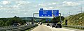
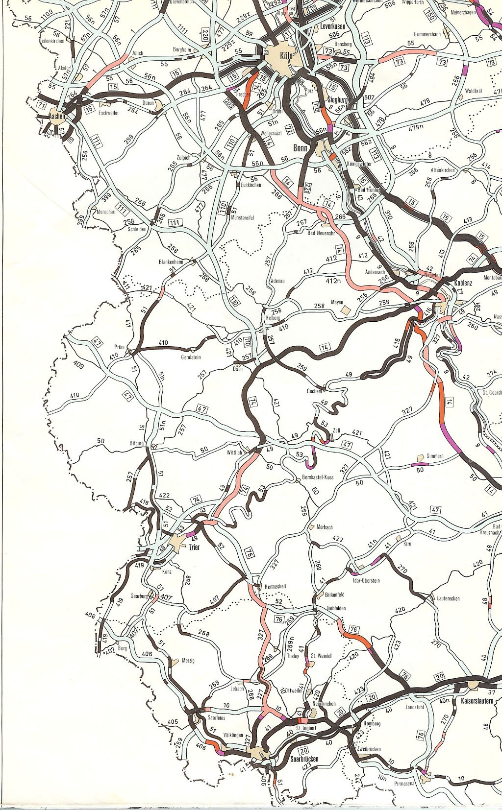
The Bundesautobahn 45 (abbreviation: BAB 45 ) - short form: Autobahn 45 (abbreviation: A 45 ) - is a German motorway that runs from Dortmund via Hagen , Siegen , Wetzlar , Gießen and Hanau to Aschaffenburg . It is part of Europastraße 41 along its entire length and is also known as the Sauerland line due to its route .
It was built in the 1960s as the second connection between the Ruhr area and southern Germany and was the first newly built motorway route after the Second World War that did not go back to plans for the Reichsautobahn from the time of National Socialism . The alignment across the mountains of the Sauerland and Siegerlands made it necessary to build numerous viaducts for the first time . Other innovations compared to the autobahns of the 1930s were a more curved route and the increased use of additional lanes on inclines.
Route
The Bundesautobahn 45 begins at the Dortmund-Nordwest intersection , where it is connected to the BAB 2 (Ruhrgebiet - Berlin ). Since a continuation of the motorway to Olfen was previously planned and this is still planned as a new federal highway, this junction has already been expanded with advance work for a complete motorway junction. The motorway initially leads through the densely populated area on the western outskirts of Dortmund and the Ruhr area towns of Castrop-Rauxel and Witten and, together with the federal motorways BAB 1 and 2, forms the Dortmund motorway ring . In this area, the federal highways 42 , 40 and 44 crossing the Ruhr area as well as the motorway-like B 54 are crossed. With the exception of the Dortmund-Eichlinghofen junction , all connections are designed as high-level motorway junctions in the shape of a clover leaf.
In the southern outskirts of Dortmund the Ardey Mountains are reached and the landscape becomes hilly. At the Westhofener Kreuz near Schwerte , the BAB 1 ( Fehmarn - Hamburg - Bremen - Cologne - Saarbrücken ) is connected and the Dortmund motorway ring is thus left. First the Ruhr , then the Lenne is crossed on two long bridges and then the BAB 46 is crossed at the Hagen junction , which leads in a westerly direction directly into the city center of Hagen . The long ascent into the Sauerland to Lüdenscheid begins south of Hagen and has a considerable difference in altitude. Between Lüdenscheid and Meinerzhagen the motorway reaches the 532.6 m above sea level. NN highest point of the entire route. This is about 1.2 km north-north-west of the Rothenstein mountain ( 600 m above sea level ). Overall, the 36 km long section between Hagen and Meinerzhagen has a total difference in altitude of 426 m, the following from Meinerzhagen to Olpe is 180 m. At the Olpe-Süd junction, the BAB 45 crosses the BAB 4 in its western section ( Aachen –Köln– Krombach ), which for many years had its eastern end point here.

At the Castrop-Rauxel-Ost junction with the BAB 42, a few kilometers south of the start of the motorway

In the southern urban area of Dortmund

Lennetal bridge near Hagen

In the Sauerland near Lüdenscheid

Route between Lüdenscheid and Meinerzhagen


South of Olpe you leave the Sauerland and reach the Siegerland . At the height of Siegen , the regional center of South Westphalia and the largest city along the BAB 45 between the Ruhr area and Aschaffenburg, the 106 m high Siegtalbrücke is the highest bridge along the entire motorway route. Then another uphill or downhill section begins. It has a height difference of 180 m over a length of 16 km and has its highest point at 504.55 m above sea level. NN on the watershed between the rivers Lahn and Sieg am Berg Kalteiche , just behind the border with the state of Hesse . On the Hessian side, the motorway then follows the Dill Valley from Haiger via Dillenburg and Herborn to Wetzlar . The Wetzlarer Kreuz connects a short section of the BAB 480 and is the only one in Germany to be built in the form of a Maltese cross due to the topography and in anticipation of increasing traffic volumes during the previously planned extension of the motorway to Koblenz .
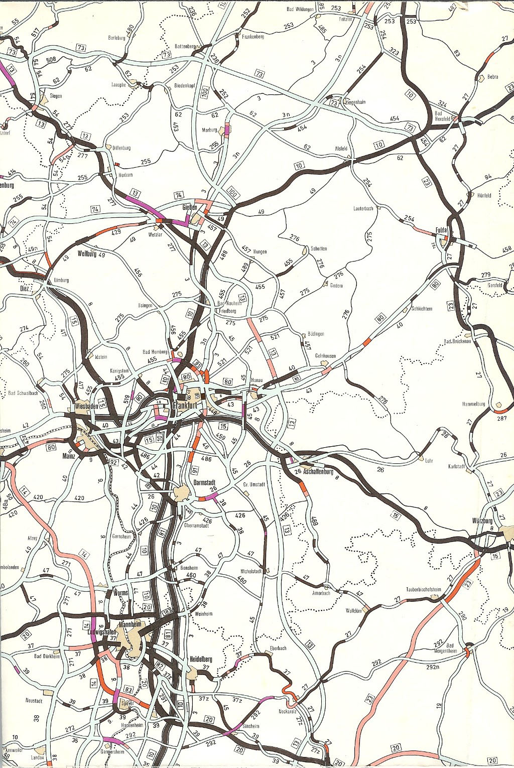
East of Wetzlar, the Lahn is crossed, leaving the low mountain range and reaching the largely flat Wetterau . The Gießener Südkreuz connects to the A 485 , which today primarily serves as a feeder to Gießen and the motorway-like B 3 to Marburg or south to Butzbach . It is part of the previously planned southern extension of the A 49 to Darmstadt .

Siegtalbrücke and Siegen-Eiserfeld

In Wilnsdorf south of Siegen

East of Wetzlar
At the Giessener Südkreuz


About 9 km further follows the Gambacher Kreuz with the BAB 5 , which was the end point of the BAB 45 for a few years. When the autobahn was built in the 1960s, only the long, two-lane crossings in a southerly direction ( Frankfurt am Main ) were passable, but the preliminary work for the further construction of the BAB 45 was already in place. When this continuation opened in 1978, however, no connections were made from Dortmund in a northerly direction and vice versa. To this day, the consequence of this is that traffic coming from the west has to use the federal highways 485 and 480 to the Reiskirchener Dreieck in order to get to Kassel . This connection also serves as a replacement for the never completed gap closure of the BAB 4 between Krombach and the Kirchheimer Dreieck .
The continuation of the motorway to Hanau is also called the Wetterau line due to the landscape it crosses and has a special feature: shortly after the connecting lanes to the BAB 5 in the direction of Frankfurt am Main, the motorway has an extra-wide median. This represents a holdover from the time when the autobahn was supposed to be extended beyond its current end point into the Stuttgart area. These are advance payments for a six-lane expansion, which was made possible by the subsequent installation of an additional lane on the left-hand side of the road in the direction of travel. The BAB 45 now leads alternately through a wide, agricultural area and some larger forest areas, then along the western edge of the Vogelsberg . At the Langenselbolder Dreieck shortly before Hanau, it meets the BAB 66 to Fulda and both motorways lead to the following Hanauer Kreuz , where the BAB 66 branches off to Frankfurt am Main and the B 43a to Darmstadt , on a shared, eight-lane route.
Behind the Hanauer Kreuz, the motorway runs through the Bulau and crosses the border with Bavaria . About 13 km of the following route are in the Free State. It leads past Alzenau along the western edge of the Spessart . On the Main Bridge Mainflingen , the BAB 45 changes back to Hesse and ends at the Seligenstädter Dreieck , which had already been built as a complete cross as a preliminary construction work for the now discarded extension through the Odenwald to Stuttgart , at the BAB 3 ( Emmerich - Ruhrgebiet - Frankfurt - Nuremberg - Passau ).

Gambach Cross
In the Wetterau near Munzenberg

Extra-wide median at Karlstein

.jpg)

history
Plans for a motorway connection between the Ruhr area, Sauerland, Westerwald and Central Hesse already existed in individual Reichsautobahn plans, but concrete plans were not carried out until after the war in the 1950s to create a second efficient connection between the Ruhr area and southern Germany , which should relieve the existing Frankfurt – Cologne route. In addition, the industrial areas around Siegen , Dillenburg and Wetzlar , at that time important locations for the steel industry, could benefit from a motorway connection. In 1966 the first longer section, and in 1971 the last section between Dortmund and Gießen, was opened to traffic, whereupon the continuation via Hanau to Aschaffenburg was tackled. A planned extension to the south through the Odenwald , over the Heilbronn area and the subsequent northeast bypass of the Stuttgart region ending at the Karlsruhe – Munich autobahn near Kirchheim unter Teck was abandoned.
Period of National Socialism: First plans
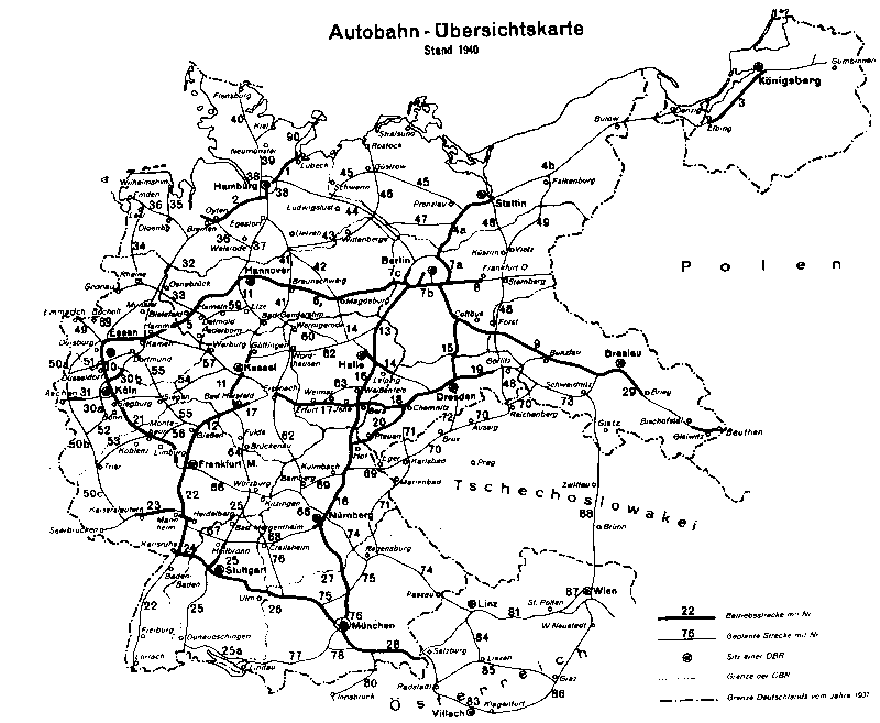
A motorway connection between the eastern Ruhr area , Siegen and Gießen already appeared on Reichsautobahn route maps from the time of National Socialism . On a network map from 1940, a planned motorway from the Ruhrtangente Dortmund- Cologne, which was then under construction , to the Reichsautobahn Hanover-Frankfurt (planned in 1926 by HaFraBa e.V. and built from 1933/34) is shown under route number 55 . At Siegen, a cross with a planned cross-connection from the Cologne area via Siegen to Kassel was also planned. Another planned connection was to lead west of Gießen into the Koblenz - Limburg area. The main concern at that time was the connection of heavy industry in the Hüttental near Siegen and in western Central Hesse around Dillenburg and Wetzlar to the network of the Reichsautobahn. Due to the Second World War, there was no further attack, especially since from 1942 all construction activity in the road network was stopped.
Immediately after the end of World War II, numerous war damage had to be repaired in the existing network, most of which were bridges that were blown up by the Wehrmacht as the Allied forces advanced. It was not until the 1950s that autobahn construction could be resumed in the Federal Republic of Germany, which was founded in 1949 on the territory of the Western Allied occupying powers , while in the Soviet occupation zone or the later GDR, new autobahn construction actually came to a standstill. First of all, routes that had already been started under the National Socialists, but which could no longer be completed due to the outbreak of war, were completed. For the time being, this concerned the Dortmund – Cologne, Aachen – Cologne, Mannheim – Saarbrücken, Karlsruhe – Basel and Frankfurt – Nuremberg routes, so that these were opened to traffic by the early 1960s.
1950s: planning resumed
The increasing traffic quickly showed that the north-south stretch of the Ruhr area - Cologne - Frankfurt am Main , which was largely from the pre-war period , as well as the Ruhr tangent Kamen - Leverkusen / Cologne , which was only completed after the war, had already reached its capacity limit. which is why a second north-south connection between the Ruhr area and the Rhine-Main area was the focus of the traffic planners. The resumption of route planning for this connection was carried out in 1957 under the then Federal Transport Minister Hans-Christoph Seebohm by five new building offices (four in North Rhine-Westphalia, one in Hesse).
First of all, it was checked whether the new road should be built as a motorway or a motor vehicle . The construction of just one lane at first, which can be extended by a second lane if necessary, was also considered. More detailed traffic studies by the Kock engineering office in 1958 recommended the construction of the road connection as a fully developed, four-lane motorway from the start. Although considerations were made regarding a standard cross-section with six strips, a decision was made against it due to the higher additional costs.
With regard to the exact route, numerous variants were examined and rejected again. The challenges of the alignment in mountainous areas quickly became apparent, especially since the few valleys of the Sauerland and Siegerland that ran in a north-south direction no longer offered any space for a motorway. Variants that included, for example, a crossing of the Siegtal and a northeastern bypass of Gießen have been postponed. To a certain extent, a waste product of this variant is the Hüttentalstrasse in Siegen , built in the early 1970s
In the end, it was decided to take the motorway from Hagen over a long slope to Lüdenscheid on the heights of the Sauerland and then to create a route along the mountain ridge to Siegen. After Siegen, another ascent to the Kalteiche and then the descent first into the Haigerbach valley, then into the Dill valley should follow. Along the western and then eastern slopes, it reaches the town of Wetzlar along the valley , crosses the Lahn and reaches the Gießen area on the edge of the largely flat Wetterau, where it ends at the pre-war Hamburg – Frankfurt – Basel motorway .
The building instructions for federal highways, cross-sectional design (BBA-Q) developed in 1955 took up numerous new insights into road construction that were made especially in the USA, especially since no new highways have been built in Germany since 1942. Under Hans Lorenz , deputy head of the Nuremberg Motorway Construction Office from 1950 to 1955 , new guidelines for the construction of new motorways were drawn up. These were used for the first time in the construction of the Spessart line between Frankfurt and Nuremberg, which began before the war, in the late 1950s to early 1960s. While the Reichsautobahn had a standardized cross-section of 24 m, which was expanded to 28.50 m in 1939 with the introduction of hard shoulder , the standard cross- section for new lines was increased to 31 m (RQ 31). Gradients of more than 4% and the use of long straight lines in a row with relatively tight curves, which is still common on Reichsautobahn, have been dispensed with from now on, which is why the motorways of the post-war period usually have slightly curved lines, especially since long straights are monotonous and tiring for the motorist .
The construction of earthworks and bridges had meanwhile also made great strides: new large-scale equipment made it possible to work more economically for excavating large amounts of earth, which enabled the route to be designed more independently of any obstacles. In addition, the decision to cross wide valleys with longer viaducts and not to drive them out was made easier by new techniques for building large bridges , which avoided additional uphill and downhill stretches and thus avoiding accident black spots.
In the planning of the Sauerland line, the newly designed concepts, which were tried and tested when the pre-war lines were unfinished due to the war, were used for the first time in a completely newly planned route.
1960s: Construction of the Sauerland line from Dortmund to Gießen
Finding the lines
The route intended for construction was determined with its start on the Ruhrgebiet – Berlin autobahn, so that the Dortmund city center is bypassed to the west and south. Together with this and the Ruhrtangente Dortmund – Cologne, it forms a motorway ring around Dortmund . From the junction at Castrop-Rauxel - Ickern near the northwestern Dortmund city limits to the cross with the Ruhr tangent at Schwerte -Westhofen, the course is characterized by the densely built-up and industrialized eastern Ruhr area. When laying out the route, consideration also had to be given to mining areas in the area of the Ardey Mountains and space for connections to connecting roads that were already four-lane at that time. Most of the junctions in the Dortmund area have therefore been designed as a flat cloverleaf cross.
After crossing the Ruhr valley, then the Lenne valley between Dortmund and Hagen, the actual mountain road begins south of the Lenne. The ascent from the Lennetal near Hagen with 100 m above sea level. NN to Lüdenscheid at 410 m above sea level. NN runs along the ridge of the ridge between the Volme and Lennetal, with a gradient of 4%. Following the eastern bypass of the city of Lüdenscheid, the route reaches the Ebbegebirge , where, after a further ascent, the highest point of the entire route is reached. This is at 532 m above sea level. NN .
One problem that arose on the Ruhr tangent (Kamen – Leverkusen) was the side crawl tracks on inclines that were reserved for slower truck traffic. Even unloaded trucks had to use these lanes, even though they often reached a higher speed than smaller cars. These lanes remained unused on weekends when there was more car traffic due to the weekend driving ban for trucks that had been in force since 1956 . There was usually no signage that would have made it possible for cars to use the lanes. When the Sauerland line was built, crawl tracks were therefore no longer used for the first time; instead, three regular lanes were designated for one direction of travel in uphill areas. Frequent lane changes were avoided by continuing to use the third lane continuously on gradients in rapid succession. The uphill stretch from Dortmund via Hagen and Lüdenscheid to the ridge of the Ebbegebirge has three lanes in a southerly direction for over 40 km. At the time of completion, it was the longest three-lane carriageway in the German motorway network. Despite the wider route, the three-lane lanes were also given a hard shoulder. Only in the case of the valley bridges was this waived in order to save costs by making the structure narrower. Conversely, by re-marking the hard shoulder on the valley bridges, a six-lane expansion could be carried out without major interventions in the building structure.
A total of one third of the motorway between Dortmund and Gießen is equipped with additional lanes in each direction, the vast majority of which are in North Rhine-Westphalia. On the Hessian side, three-lane one-way carriageways were not built on a large scale, since the gradient areas are further apart due to the different character of the landscape and a continuous three-lane carriageway was not pursued for economic reasons.
After crossing the Ebbeebirge, Meinerzhagen is reached, then the route turns in a south-easterly direction to Olpe , where the Sauerland is left and the Siegerland is reached. Even on the approx. 60 km between Lüdenscheid and Siegen, the motorway largely follows the mountain ridge. To cross the Sieg Valley , a 106 m high and 1050 m long bridge was built, for its construction, the highest highway bridge in North Rhine-Westphalia. The construction of the Siegtal valley and the construction of a 30 m high bridge, which was discussed as an alternative to the implemented large bridge, was not pursued due to the higher construction effort and the associated additional costs. The connection to Siegens, the regional center and largest city in the South Westphalia region, was connected due to the topography via a 5 km long feeder road that branches off the motorway north of the Siegtalbrücke and has a connection to the B 54 in the Eiserfeld district with a height difference of around 100 m .
To the south-east of Siegen, the freeway route follows another uphill stretch which, with a difference in altitude of approx. 180 m, reaches an altitude of 504 m above sea level. NN leads. This point on the Kalteiche mountain is on the watershed between Sieg and Lahn and near the state border between North Rhine-Westphalia and Hesse . If planning from the 1930s still provided for a guided tour of the Reichsautobahn route 55 through the Westerwald and thus the Rhineland-Palatinate area, when planning was resumed after the Second World War, it was decided to take a guided tour down the slope of the Dilltal towards Wetzlar.
The route in the Dillenburg area was complex . A variant of leading the motorway through a tunnel after the second Dill crossing was no longer necessary due to the unsuitable rock and the low overburden. Instead, a 900 m long viaduct was built over the Dill valley near Sechshelden and a connection to the B 277 in the form of a feeder with two triangles, which means that the motorway runs relatively close to the town of Dillenburg. The tour on the western slope of the valley required a relatively tight curve radius of 600 m. Instead of tunnels, some points south of Dillenburg were cut into the cut.
Between Herborn and Ehringshausen , the Dill is crossed a third time and the route follows continuously along the eastern slope of the valley to Wetzlar. At Aßlar , a full-fledged motorway junction has already been built as a preliminary work for the planned Koblenz - Gießen motorway, to which a connecting stretch of just a few kilometers in the direction of Wetzlar or Blasbach is connected. Due to the topography on the valley slope and a nearby limestone quarry, construction as a conventional trefoil cross was not possible, which is why all connecting ramps lead as direct ramps to the connecting route to Wetzlar. To this day it is the only full-fledged Maltese cross in Germany.
The Lahn is crossed east of Wetzlar and the low mountain range character of the surrounding landscape continues to decline. The connection to the Kassel – Frankfurt autobahn was realized south of Gießen at the Gambach autobahn threeick , which was already being built as a full autobahn junction with the continuation of the Sauerland line towards Hanau . Even after a planned connection to the Stuttgart area, it was assumed that most of the traffic from Dortmund would change to the motorway in the direction of Frankfurt. Therefore, the connecting ramps Dortmund – Frankfurt were designed as two-lane direct ramps. Due to the planned Koblenz – Gießen motorway, which is supposed to represent this connection, no ramps have been built from the direction of Dortmund in the direction of Kassel.
Construction work
Construction of the Sauerland line began in the early 1960s after the route decision was made in November 1959. The first short section could already be completed in 1963, it was the 4 km long section between the Westhofen cross and the Dortmund-Süd junction. Together with this, the Westhofen junction on the Hamburg – Cologne autobahn, today's BAB 1 , went into operation.
Three years after starting work in the Lüdenscheid motorway construction department, the complex construction of the mountain stretch in the northern section of the slope from Hagen to Lüdenscheid began in 1963. The construction of the numerous viaducts proceeded very quickly at first, so that a complete release of the line for the end of 1967 appeared. The opening was delayed by a few months, especially since the Rahmedetalbrücke was not completed until October 1967 and the following winter forced the work to rest. The section between the Hagen junction and the Lüdenscheid junction (then Lüdenscheid-Ost ) was finally opened to traffic by Federal Transport Minister Georg Leber on October 24, 1968 after a construction period of just over 4 years . The construction costs for the approximately 20 kilometer long section amounted to approx. 165 million DM, of which 70 million DM went to the construction of the six viaducts.
After ten years of construction and 1.5 billion DM construction costs, the last section between Lüdenscheid and Freudenberg was released on October 26, 1971. The official opening of the Sauerland Line with Transport Minister Georg Leber and Federal Chancellor Willy Brandt took place at the Sauerland service station near Lüdenscheid. With the completion of the section, the distance from Dortmund to Frankfurt has been reduced by approx. 15% from 250 km (via Cologne) to 213 km.
The northern extension from the Dortmund-Süd junction to the end point at the Dortmund-Nordwest junction was completed in two stages: 1972 to the Dortmund-West junction (then the B 1 , today's A 40 ) and 1974 to the current end point at the Dortmund-Nordwest junction (today's A 2 ).
1970s: Construction of the Giessen – Aschaffenburg weather line
Finding the lines
A continuation of the route from Gießen to the Cologne – Frankfurt – Würzburg – Nuremberg motorway near Aschaffenburg was already included in the plans as a network extension in 1962. As part of a traffic survey carried out from 1963 to 1965, a total of seven different routing variants were examined. In 1967 the decision was made in favor of planning case 6 , which determined the location of the Main crossing and the link structure to the Frankfurt – Nuremberg motorway. After the planning documents were submitted to the Hessian and Bavarian state planning authorities in 1968, the route for the 72 km long section was finally determined in 1972. A total of 12 km of the route are here in Bavarian territory.
When the northern section was built, the junction near Gießen with the Hamburg – Frankfurt – Basel motorway (today Gambacher Kreuz ) was already designed for further construction to the east. Initially, only the two-lane connecting ramps in the direction of Frankfurt were put into operation, before a crossing structure in the form of an incomplete clover leaf was built northeast of the confluence in the south. Connection ramps from north to west and vice versa were dispensed with in favor of the planned Koblenz – Gießen – Hattenbacher Dreieck motorway.
The main aim of the route was to keep as large a distance as possible from populated towns and at the same time to take into account the economic conditions, such as open-cast lignite mining in the area around Wölfersheim or the agricultural areas. The route therefore follows east of Munzenberg on a ridge between the mining fields of the opencast mines. Then a large forest area is crossed and first the Nidda valley , then the Niddertal valley , before the westernmost foothills of the Vogelsberg are crossed and the Kinzig valley near Langenselbold is reached.
A route east of Niederrodenbach was originally planned for the continuation from Hanau to Aschaffenburg , but due to better connections with the then planned motorways Frankfurt – Hanau– Fulda (today A 66 ) and Dieburg - Hanau (today B 45 and B 43a , at times A 683 ) brought the route closer to Hanau and built a crossing structure west of the village.
In the Bavarian area that now follows, the route was laid between the two settlement areas along the Main around Karlstein and on the slope of the Spessart around Alzenau , before the river is crossed and the motorway at the Seligenstädter Dreieck ends in Hessian territory 4 km behind the Main bridge . The junction was already built as a fully developed trefoil cross in order to enable a later extension to the south towards Stuttgart .
To the northeast of Hanau, two junctions were built as part of the construction of the Frankfurt – Hanau – Fulda federal motorway, including a 3 km long joint route. A different traffic management was not possible due to various conditions when planning the route.
Overall, the route in this section has been adapted more to the landscape, but the maximum longitudinal gradient is less than 4%. In contrast to the northern part, a standard cross-section of 37.50 m was chosen for the construction, with the central reservation being 12.50 m wide. As a result, a further lane can be added to the median in each direction of travel without major reconstruction work having to take place at the junctions and bridge structures. Since the highway but never on the A3 was extended beyond and is therefore also frequented thirty years after the release only relatively weak, it is questionable whether this development will ever take place.
Construction work
Construction of the Gießen – Aschaffenburg line began in the mid-1970s in the section between the Florstadt junction and the Langenselbolder triangle, which was completed in 1976. In 1977 the section from the Wölfersheim junction to the Florstadt junction followed. In the following year, when the Gambacher Kreuz – Wölfersheim and Langenselbolder Dreieck – Seligenstädter Dreieck sections went into operation, the section was completely completed. Due to the large width of the (green) central strip, the building regulations allowed the otherwise usual guardrails to be dispensed with. After several serious accidents in which vehicles had entered the opposite lane due to driving errors, crash barriers were also retrofitted here.
The work between the Langenselbolder and the Seligenstädter Dreieck began in 1976. About 12 km of the route near Alzenau and Karlstein are in Bavarian territory and are therefore under the responsibility of the Nuremberg Motorway Directorate or today's Northern Bavaria Motorway Directorate . The most outstanding structure is the 450 m long Mainflingen bridge a few kilometers before the end of the autobahn near Mainhausen . For a continuation through the Odenwald in the direction of Stuttgart , which was still planned at the time , the junction with the BAB 3 was built as a cloverleaf-shaped motorway junction, with all ramps already built but not yet used. The junction was therefore initially called the Seligenstädter Kreuz . This section was opened to traffic on June 26, 1978.
After the plans for a continuation to Stuttgart were given up in 1980 and the planned southern extension by a few kilometers to the B 26 was finally canceled in 1986, the half-finished motorway junction was renamed the Seligenstädter Dreieck . The place name was retained, although the triangle is in the area of the municipality of Mainhausen and not the city of Seligenstadt. The eastern area lies on Bavarian land and belongs to the municipality of Stockstadt am Main .
List of traffic clearances
| section | year | km |
|---|---|---|
| AD Dortmund-Northwest - AS Dortmund-West | 1974 | 10.5 km |
| AS Dortmund-West - AS Dortmund-South | 1971 | 10.2 km |
| AS Dortmund-Süd - Westhofener Kreuz | 1963 | 4 km |
| Westhofen Cross - AK Hagen | 1967 | 8 kilometers |
| AK Hagen - AS Lüdenscheid-Ost | 1968 | 20 km |
| AS Lüdenscheid-Ost - AS Freudenberg | 1971 | 48.4 km |
| AS Freudenberg - AS Siegen-Eisern | 1968 | 13 km |
| AS Siegen-Eisern - AS Haiger / Burbach | 1967 | 14 km |
| AS Haiger / Burbach - AS Dillenburg | 1968 | 8 kilometers |
| AS Dillenburg - AS Herborn-Süd | 1969 | 12 km |
| AS Herborn-Süd - AS Ehringhausen | 1970 | 8 kilometers |
| AS Ehringhausen - AS Wetzlar-Ost | 1971 | 15.4 km |
| AS Wetzlar-Ost - Gambacher Kreuz | 1966 | 18.3 km |
| Gambacher Kreuz - AS Wölfersheim | 1978 | 13.1 km |
| AS Wölfersheim - AS Florstadt: | 1977 | 13.0 km |
| AS Florstadt - Langenselbolder Dreieck | 1976 | 22.4 km |
| Langenselbolder Dreieck - Seligenstädter Dreieck | 1978 | 23.1 km |
numbering
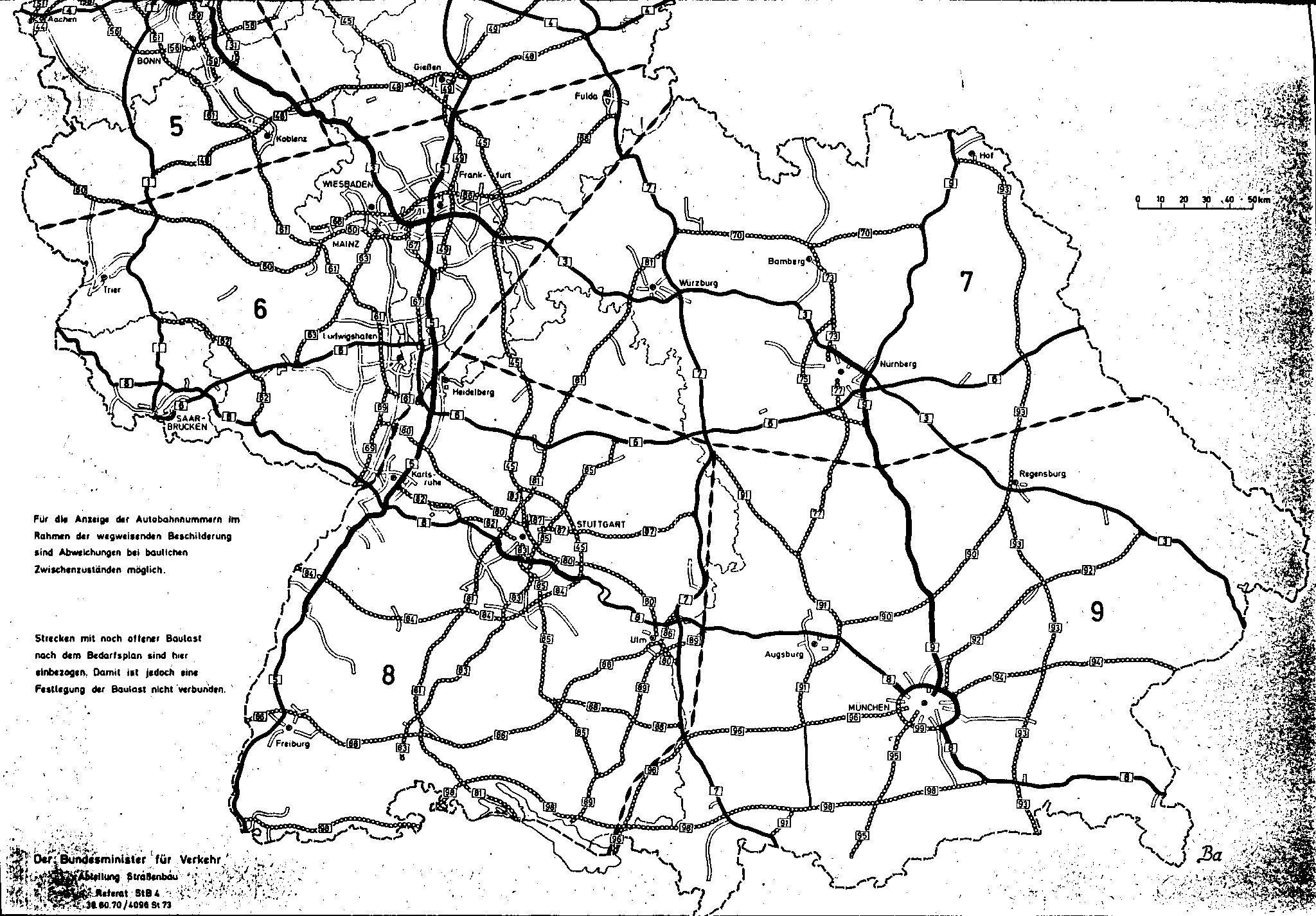
In the plan for the expansion of the federal highways from 1971 to 1985, the entire route from Dortmund via Gießen and Aschaffenburg to Stuttgart was included under the internal name “Autobahn 13”. At that time, the information boards only indicated federal and European roads. With the introduction of the new numbering system on January 1, 1975, the Olfen – Dortmund – Gießen – Aschaffenburg – Kirchheim u. Partly as federal motorway 45, short BAB 45 dedicated. At this point in time, the Dortmund – Gambacher Kreuz section was completed and the continuation to the Seligenstädter Dreieck was under construction.
Route plans not executed
planned southern extension (Odenwald-Neckar-Alb motorway)

In the 1960s and 1970s was planned motorway as "Odenwald-Neckar-Alb-highway" (ONAA) south on the A3 beyond Schaafheim , space Gross-Umstadt , Sandbach (Breuberg) ( B 426 ), Rimhorn , Vielbrunn , Boxbrunn im Odenwald near Michelstadt ( B 47 ), Würzberg , Hesselbach (Hesseneck) , Schloßau (Mudau) , Mudau- Reisenbach , Waldbrunn (Odenwald) , Reichenbuch near Mosbach ( B 37 ), Asbach (Obrigheim) ( B 292 ) , Helmstadt-Bargen , Untergimpern , Kirchardt (motorway junction with A 6 ), Massenbachhausen , Schwaigern ( B 293 ), Nordheim (Württemberg) near Lauffen , Talheim ( B 27 ), Neckarwestheim , Mundelsheim (motorway junction with A 81 ), Steinheim an der Murr , Rielingshausen , Kirchberg an der Murr , Burgstetten , Waldrems bei Backnang ( B 14 ), Berglen , Winterbach (motorway junction with A 87 ), Lichtenwald , Reichenbach an der Fils (motorway junction with A 80 ) and Kirchheim unter Teck ( B 297 ) to to extend to the A 8 at Holzmaden . This planning, which was already well developed, was officially abandoned in 1979 by the Baden-Württemberg state government for ecological reasons. The route was no longer included in the requirements plan of the second law of 25 August 1980 amending the law on the expansion of federal highways from 1971 to 1985 (Federal Law Gazette 1980, Part I, p. 1614). However, on the previous route of the A 45 the new construction of a federal road between the A 6 and the A 81 (two-lane, urgency level II), between the A 81 and the B 14 near Backnang (four lanes, urgency level I) and between Backnang and the A 8 near Kirchheim unter Teck (two-lane, urgency level II) planned. From the Seligenstädter Kreuz the A 45 was to be continued to the A 680 / B 26 Darmstadt - Aschaffenburg. The third law of April 21, 1986 amending the law on the expansion of federal highways (Federal Law Gazette 1986, Part I, p. 557) also led to the deletion of these projects.
Planned northern extension
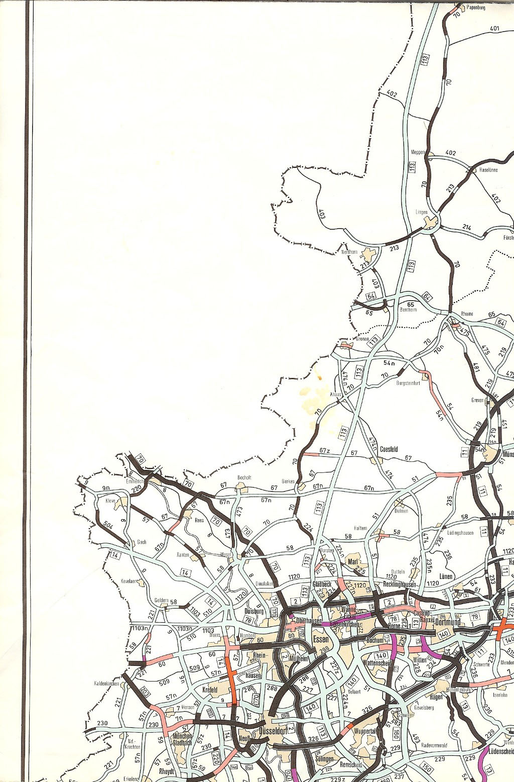
A four-lane, motorway-like extension of the Gießen-Dortmund motorway north of the Dortmund-Nordwest motorway junction as the B 235n via Waltrop and Datteln to the Olfen area with a connection to the old B 235 was already in the plan for the expansion of the federal trunk roads from 1972 to 1985 intended. Between Olfen, Dülmen , Coesfeld , Ahaus and Gronau , a new two-lane building should follow the B 474n . With the restructuring of the motorway network from January 1, 1975, it was planned to continue the A 45 into the Olfen area. In contrast, the construction of a motorway north of Olfen was not intended. In the second law of 25 August 1980 amending the law on the expansion of federal highways from 1971 to 1985 (Federal Law Gazette 1980, Part I, p. 1614), the extension of the A 45 was deleted. Instead, the new construction of the B 474n should take place between the Dortmund-Nordwest and Dülmen intersection (urgency level I), in the section of the Waltrop OU in a four-lane expansion. The third law of April 21, 1986 amending the law on the expansion of federal highways (Federal Law Gazette 1986, Part I, p. 557) provided for the section south of Dülmen - Olfen only as further planning. The Olfen - Kreuz Dortmund-Nordwest section was still included in the urgent need, but only as a new two-lane federal road. The OU Dülmen was an ongoing project. In the Federal Transport Infrastructure Plan 2003, the following sections of the A 45 are still included for implementation as B 474:
- OU Waltrop (8.4 km, four lanes, urgent need)
- OU Datteln (3.3 km, two-lane, urgent need)
Lawsuits against the planning approval decision were pending at the Münster Higher Administrative Court against OU Datteln, but were rejected on January 18, 2013. The Federation for the Environment and Nature Conservation Germany (BUND eV) lodged a complaint with the Federal Administrative Court of Leipzig against the non-admission of the appeal, which overturned this decision in January 2014 and referred it back to the Higher Administrative Court in Münster.
The 2003 Federal Transport Infrastructure Plan also contains the OU Dülmen (B 474, 2 construction sections, a total of 11 km, two-lane, urgent need) and the OU Olfen (B 474, 6 km, two-lane, further need), but they are not part of the planning at any time to the A 45 were.
Traffic importance
Seven years after the plan approval decision, the Kocks engineering office, which had already carried out the investigation of the road cross-section of the motorway planning, again prepared a traffic report. The initiators were members of the Bundestag, some state parliaments as well as municipal and economic associations from the regions affected by the autobahn, which joined together in a working group autobahn Dortmund-Hagen-Siegen-Gießen . At that time, most of the motorway was still under construction, only sections between Dortmund and Hagen and between Wetzlar and Gambach were completed.
The economic and spatial planning-oriented report came to the conclusion that a continuous route Dortmund – Gießen both significantly reduced the travel time compared to the old route via the Cologne – Frankfurt motorway and saved enormous operating costs by relieving the burden on that route. Around half of the operating costs saved were accounted for by leisure and recreational traffic between metropolitan areas and the low mountain range. The motorway connection was classified as very important for long-distance freight traffic between the North Sea coast and southern Europe.
The most heavily used sections of the BAB 45 today were in 2015 between the Westhofener Kreuz and the Schwerte-Ergste junction and on the shared section with the BAB 66 between the Langenselbolder Dreieck and the Hanauer Kreuz, each of which has an average of over 90,000 vehicles per day. In the entire mountain section between the Westhofener and the Gambacher Kreuz, an average of 50,000 to 60,000 vehicles drive the motorway every day, the section from the Gambacher Kreuz to the Seligenstädter Dreieck generally has a lower traffic load; here, with the exception of the double-numbered route near Hanau, 30,000 up to 40,000 vehicles.
Others
Full closure near Dortmund in January 2012
On January 17, 2012, a break in daylight on the median was discovered between the Dortmund-Süd junction and the Dortmund / Witten motorway junction at the level of the “Flöz Mausegatt ” and “ Johannes Erbstollen ” car parks . The motorway had to be completely closed. Up to three seams have been discovered, some of which are only three meters below the surface and some of which are up to 20 meters deep. In three-shift operation, a total of 80 cavities were filled with 800 tons of cement mixture.
De-icing agent spray systems
The section between Hagen and Meinerzhagen is particularly prone to congestion and accidents due to the climatic conditions in winter due to ice and snow and all year round due to fog. Since the 1980s, there has been a de-icing agent spraying system and a traffic warning system between Lüdenscheid-Süd and Drolshagen on this incline at the valley bridges between Hagen and Lüdenscheid-Nord . There is also a de-icing agent spraying system between the Wilnsdorf and Haiger / Burbach junctions, as the height of 500 meters above sea level has to be crossed.
Renaming of the motorway junction "Olpe-Süd"
Efforts were made by the city of Siegen to rename the Olpe-Süd ( A4 ) motorway junction to "Siegen-Nord". This was justified by the fact that after the construction of the A 4 and the connection there to the Siegen city motorway (" Hüttentalstrasse "), the Siegen regional center is directly connected from the north. The Federal Transport Ministry has rejected a request to the city of Siegen on 1 February of 2005.
Extension of the parking facilities on the federal highway 45
Due to the 20,000 missing parking spaces nationwide, the State Office for Roads in North Rhine-Westphalia intends to expand the Schwiendahl and Brenscheid parking lots in the city of Lüdenscheid and two additional parking spaces outside the Lüdenscheid city area in 2013. The capacity of the Schwiendahl rest area is to be expanded from eight today to more than 20 truck spaces. And the Brenscheid car park directly opposite is to grow from currently 14 to up to 26 truck parking spaces. The green areas in the parking lots should largely disappear. In addition, car parking spaces are to be created along a lane facing the motorway. In addition, there should be a bypass around the outside. The chairman of the planning and environmental committee of the city of Lüdenscheid considers the planned expansion of the parking lots to be sensible, since the traffic on the autobahn is increasing.
Signs for the valley bridges
Most of the viaducts in the North Rhine-Westphalian section of the A 45 had information boards that were originally blue and gave information about the name of the bridge and the height above sea level at which the roadway of the viaduct is located. However, around 2013 all of these signs were removed. Why this happened is not known. The counterparts in Hesse, originally in blue, were renewed a few years ago.
Bridge damage

In the Blasbachtal bridge , which was completed in 1971 , cracks (predominantly in the range of 0.2 mm width) appeared, which were the subject of a nationwide ruling by the Frankfurt Higher Regional Court.
From 1999 to 2002 the Haiger Dill Valley Bridge was replaced by a new one due to structural damage. The replacement of the Windelbach viaduct and the renovation of the Ambachtal bridge have been underway since the beginning of 2009 . Shortly before the start of construction, the A 45, direction Wetzlar, had to be closed at short notice due to frost damage on the Windelbachtal bridge.
In the course of the A 45 between the Gießener Südkreuz and the state border with North Rhine-Westphalia, further bridges show damage. Therefore, since January 12, 2009, a speed limit of 60 km / h in both directions has been in effect on ten other bridges for trucks; in front of the Windelbach viaduct, a speed funnel for trucks has been set up at 40 km / h, which is unusual on the motorway, in order to increase shear and braking forces to prevent the building. Heavy goods and dangerous goods as well as vehicles with a gross vehicle weight of more than 44 tons are still not allowed to pass the section of the route. The first construction phase, the superstructure in the direction of Gießen and the transfer of traffic to this bridge section, has been completed since November 2010 . The project was completed in December 2012 with the handover.
Eleven bridges will have to be renovated in the next few years. The renovation should enable the bridges to be used for another ten years before they are replaced by new buildings. In March 2010, the creation of the demolition concepts and the planning of replacement new buildings for 16 bridge structures between the Gambacher Kreuz and the state border Hesse / North Rhine-Westphalia were put out to tender. All new bridges to be built are to be designed for a six-lane cross-section.
In the North Rhine-Westphalian section of the A 45, too, many of the bridges have either to be significantly retrofitted or, in some cases, completely replaced due to the investigations and recalculations. In addition, the entire section between Dortmund and Hesse is to be expanded to include three lanes. A spectacular project is the new construction of the Lennetal Bridge , which has been underway for several years .
The Main Bridge Mainflingen will also have to be replaced by a new building in the coming years.
Protests against the new construction of the Sechsheldener Viaduct
The six-lane valley bridge Sechshelden of the federal highway 45 has spanned the village of Sechshelden since 1968 . Since the bridge can no longer withstand the current traffic conditions, it has to be demolished. The citizens' initiative “MuT” (“People under the Viaduct”) was founded in 2010 against the new building at the same location. The citizens' initiative calls for the implementation of a self-developed "tunnel solution" and is in talks with Haigerer , Wiesbaden and Berlin politicians. However, due to high additional costs, the federal government is calling for a new building on site.
Motorway section in Bavaria
Although the last approx. 13 km of the autobahn run in Bavarian territory ( Lower Franconia , Aschaffenburg district ), there is no sign on the entire section of the German autobahn stating that you are in Bavaria. The change of state can only be recognized by the differently designed blue signposts, since the RWBA 2000 valid for German motorways is not used in Hesse . There is only an indication that you are changing the federal state in the Seligenstädter Dreieck on the connection from the A 45 to the A 3 to Würzburg .
Mainflingen transmitter
Shortly before the end of the autobahn at the Seligenstädter Dreieck, there is a transmitter located directly on the western edge of the lane, which contains the DCF77 time signal transmitter .
Responsibilities of the motorway maintenance depots
As of January 1, 2016, the responsibilities for the A 45 were as follows:
- Free State of Bavaria
- in the area of the junction Alzenau-Nord (44) and junction Kleinostheim (47) at the Hösbach motorway maintenance facility.
Common swifts and peregrine falcons as breeding birds on motorway bridges
2003 a breeding colony was from on the highway bridge Ronnewinkel swifts discovered. From 2003 to 2013 between 29 and 44 breeding pairs were documented in the hollow chambers under the roadway. Peregrine falcons breed on several bridges on the A 45 .
literature
- Franz Krins, Eugen Schleicher: Bundesautobahn Dortmund-Gießen, Sauerland line . Reference: Federal Highway Research Institute . 1971
- Klaus Schefold, Ltd. Reg.-Building Director a. D. and Alois Neher, senior councilor a. D. on behalf of the Autobahn Office Baden-Württemberg: 50 years of motorways in Baden-Württemberg . 1986
Web links
- Autobahn Online via the formerly planned Odenwald-Neckar-Alb Autobahn
- Detailed route description of the federal motorway 45
- Gießener Anzeiger from February 16, 2010: Two bathing lakes were created as a result of the A 45 construction
- Website for the major construction site TB Windelbach / Ambach
- Images of the "Sauerland line" in the image archive of the LWL media center for Westphalia
- Strabag film about the construction of the Sauerland line
- Information on the subject of A45: Expansion and bridge renovation on the website of the State Office for Road Construction NRW
- Information on the subject of the A45 (including renovation of the bridges) on the Hessen Mobil website - road and traffic management
Individual evidence
- ↑ Renovation (new construction) of the Rälsbach viaduct . Information on the website of the State Office for Road Construction NRW (accessed: November 6, 2017).
- ^ Renovation (new construction) of the Rinsdorf viaduct . Information on the website of the State Office for Road Construction NRW (accessed: November 6, 2017).
- ↑ Sauerland line A45 - The queen of the motorways is 40 years old. derwesten.de, December 5, 2011, accessed on August 10, 2013 .
- ↑ Motorway overview map. As of 1940. Retrieved on May 8, 2013 (map).
- ↑ a b c History of the A 45. autobahn-online.de, accessed on December 29, 2016 (Dortmund – Gießen).
- ^ WA media group: Sauerlandlinie - Queen of the motorways. Retrieved April 23, 2020 .
- ↑ Newspaper article of October 26, 1971: A rose for every kilometer - Transport Minister Georg Leber opened the Sauerland Autobahn in the presence of Federal Chancellor Willy Brandt
- ↑ History of the A 45 autobahn-online.de, accessed on December 29, 2016 (Gießen – Aschaffenburg).
- ^ "Seligenstädter Dreieck" on Mainhausen marker. op-online.de, May 26, 2014, accessed on April 29, 2020 .
- ↑ Construction work on federal trunk roads in 1972. Expansion of federal trunk roads from 1971 to 1985. Annex to the road construction report 1972. Federal Minister of Transport, Road Construction Department, accessed on May 8, 2013 (map excerpt).
- ↑ Construction work on federal trunk roads in 1972. Expansion of federal trunk roads from 1971 to 1985. Annex to the road construction report 1972. Federal Minister of Transport, Road Construction Department, accessed on May 8, 2013 (map excerpt).
- ↑ Construction work on federal trunk roads in 1972. Expansion of federal trunk roads from 1971 to 1985. Annex to the road construction report 1972. Federal Minister of Transport, Road Construction Department, accessed on May 8, 2013 (map excerpt).
- ↑ Construction work on federal trunk roads in 1972. Expansion of federal trunk roads from 1971 to 1985. Annex to the road construction report 1972. Federal Minister of Transport, Road Construction Department, accessed on May 8, 2013 (map excerpt).
- ↑ a b Structure and numbering of the federal motorways. Planned overall network. As of June 15, 1974. Federal Minister of Transport, Road Construction Department, accessed on May 9, 2013 (map excerpt).
- ↑ a b Structure and numbering of the federal motorways. Planned overall network. As of June 15, 1974. Federal Minister of Transport, Road Construction Department, accessed on May 9, 2013 (map excerpt).
- ↑ A 45 Aschaffenburg - Kirchheim uT
- ↑ Construction work on federal trunk roads in 1972. Expansion of federal trunk roads from 1971 to 1985. Annex to the road construction report 1972. Federal Minister of Transport, Road Construction Department, accessed on May 8, 2013 (map excerpt).
- ↑ Network of federal motorways and federal highways. Status January 1, 1976. Federal Minister of Transport, Road Construction Department, accessed on May 9, 2013 (map excerpt).
- ↑ Complaints against bypasses dismissed. halloherne UG, January 21, 2013, archived from the original on March 1, 2013 ; accessed on May 9, 2013 (Internet contribution).
- ↑ Press release: B 474n - Datteln bypass: BUND success before the Federal Administrative Court ( Memento from March 15, 2014 in the Internet Archive )
- ↑ A 45 - The infarct threatens! , Verkehrsverband Westfalen e. V.
- ^ Report of the Federal Highway Research Institute .
- ↑ Gerald Nill: A45 in Dortmund is closed at least until Sunday night. In: The West The portal of the WAZ media group. January 23, 2012. Retrieved January 25, 2012 .
- ↑ More truck spaces on the A 45 in 2013. In: come-on.de. February 2, 2013, accessed October 8, 2017 .
- ↑ Stefan Werth: A 45: Tempo 60 for trucks on eleven bridges. In: Transport - The newspaper for freight transport. January 13, 2009, accessed October 8, 2017 .
- ↑ Projects under construction ( Memento from March 4, 2016 in the Internet Archive )
- ↑ Motorway bridges are crumbling ( Memento from December 17, 2015 in the Internet Archive )
- ^ Hessian State Office for Roads and Transport, TED document no. 47899-2010, March 16, 2010 ( Memento from December 31, 2014 in the Internet Archive )
- ↑ Project "A45: Expansion and bridge renovation" on the website of the State Office for Road Construction NRW with further evidence (accessed: July 30, 2017).
- ↑ A45: New construction of the Lennetal bridge . Information on the website of the State Office for Road Construction NRW (accessed: July 30, 2017).
- ↑ New construction planned for the Main Bridge on the A 45
- ↑ [1]
- ↑ CDU Haiger stands united behind the citizens of Sechshelden! ( Memento from July 22, 2012 in the web archive archive.today )
- ↑ http://www.mut-sechshelden.de/uber-uns/
- ↑ Thorsten: July 2015: Federal government gives Hessen a clear mandate. In: MuT - people under the valley bridge Citizens' Initiative Sechshelden e. V. July 23, 2015, accessed October 8, 2017 .
- ↑ Supreme building authority in the Bavarian State Ministry of the Interior, for construction and traffic: Free State of Bavaria - Road overview map - Responsibilities of the motorway maintenance authorities . PDF. January 1, 2016, online at www.baysis.bayern.de, accessed on September 17, 2016.
- ↑ Arndt Wellbrock, Christina Bauch, Jan Rozman, Klaudia Witte: Got under the wheels - behavioral ecological studies on swifts in a motorway bridge near Olpe. Contributions to the fauna and flora of the Siegen-Wittgenstein district, Volume 10: 57-.62
