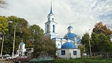
Donskoy
| city
Donskoy
Donskaya
|
||||||||||||||||||||||||||||||||||||||||
|
||||||||||||||||||||||||||||||||||||||||
|
||||||||||||||||||||||||||||||||||||||||
| List of cities in Russia | ||||||||||||||||||||||||||||||||||||||||
Donskoi ( Russian Донско́й ) is a Russian city with 64,552 inhabitants (as of October 14, 2010) in the Tula Oblast . It is located 65 km southeast of the regional capital Tula .
history
The place was first mentioned in a document in 1572. Originally the area was named Bobriki , based on the Bobrik river, whose name in turn comes from Bobr - in German beaver - and probably goes back to the abundant population of these animals in the rivers of Central Russia at the time .
1773–1776 Tsarina Catherine the Great had a property built near Bobriki for her illegitimate son, who was given the surname Bobrinski after the place name. Today only a church building from 1778 and the family mausoleum of the Bobrinskis remain from this estate.
In 1881 lignite deposits were developed in the vicinity of the village . A miners' settlement was created for the dismantling, which was given the name Donskoi in reference to the nearby Don river . In 1939 Donskoi was given city status.
In 2005, the previously independent town were Severo-Zadonsk (17,249 inhabitants) and the settlements of urban type Komsomolski , Nowougolny , Podlesny , Rudnev , Sadonje and Schachtjorski (together 19,659 inhabitants; all figures 2002) incorporated to Donskoi, the population of the city that more than doubled. However, the total number of inhabitants in all of the combined towns has been declining since around 1970.
Population development
| year | Residents | ||||||||
|---|---|---|---|---|---|---|---|---|---|
| Donskoy | Severo-Sadonsk | Komsomolski | Nowougolny | Podlesny | Rudnew | Sadonje | Shakhtyorsky | total | |
| 1939 | 13,385 | ... | ... | 10,203 | ... | ... | 12,732 | ... | 36,320 |
| 1959 | 30,310 | 23,159 | ... | 7,430 | ... | 4,697 | 6.224 | 5,327 | 77,147 |
| 1970 | 33,402 | 22,417 | 2,932 | 6,289 | 5,556 | 3,769 | 4,450 | 3,779 | 82,594 |
| 1979 | 35,411 | 21,792 | 2,423 | 6.106 | 4,406 | 3,243 | 3.213 | 3,363 | 79,957 |
| 1989 | 36,158 | 20,378 | 2.120 | 7,224 | 2,886 | 2,693 | 2,318 | 3,051 | 76,828 |
| 2002 | 32,745 | 17,249 | 2.983 | 7,277 | 1,796 | 2,190 | 1,451 | 3,962 | 69,653 |
| 2010 | 64,552 | 64,552 | |||||||
Note: census data
Economy and Transport
Today, lignite mining near Donskoi only plays a subordinate role. The city has over 30 industrial plants, including mechanical engineering, furniture and textile factories. There is a train station in Donskoi, from which there are connections to Tula, Novomoskowsk , Kaluga , but also Syzran and other places in the Volga region. The next trunk road is the M 4 , which passes through the nearby Uslowaya .
sons and daughters of the town
- Julija Snigir (* 1983), actress and model
Individual evidence
- ↑ a b Itogi Vserossijskoj perepisi naselenija 2010 goda. Tom 1. Čislennostʹ i razmeščenie naselenija (Results of the All-Russian Census 2010. Volume 1. Number and distribution of the population). Tables 5 , pp. 12-209; 11 , pp. 312–979 (download from the website of the Federal Service for State Statistics of the Russian Federation)
Web links
- Donskoi on mojgorod.ru (Russian)


