Dornbach (Vienna)
| Dornbach | |
|---|---|
| coat of arms | map |

|

|
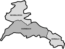
Dornbach is a district of Vienna . The formerly independent municipality was incorporated in 1892 with two other western suburbs of the capital to form the 17th district of Vienna Hernals . Today Dornbach is one of 89 Viennese cadastral communities .
geography
Dornbach is nestled between Heuberg, Schafberg and Gallitzinberg and between the districts of Neuwaldegg in the northwest and Hernals in the east. The border to the cadastral community of Hernals is in the area of the suburb line , more precisely along Heigerleinstraße and Seitenberggasse, that to Neuwaldegg west of Hans-Leinkauf-Platz. In the west, Dornbach borders on Hadersdorf-Weidlingau in the Penzing district and in the northeast on Gersthof and Pötzleinsdorf in the district of Währing . The cadastral municipality of Dornbach covers an area of 558.13 hectares , making it the largest of the three districts of Hernals. The borderline of the statistical census district Dornbach, comprising three census districts, which only describes the oldest settlement area including the surrounding slopes, differs from that of the cadastral municipality of the same name, which also includes parts of the census districts Alszeile and Äußere Hernalser Hauptstrasse.
history
The place was first mentioned in a document in 1044. The document attests that Sighard the IV., Count of Salzburg and Chiemgau , donated two noble hats [ housed farms] on the Als to the St. Peter monastery in Salzburg . These two Edelhuben are assumed to be the original settlements of Dornbach and the neighboring Hernals, but the name Dornbach was first mentioned as Doringinpach around 1115 . The coat of arms of Dornbach - two crossed black keys on a gold background - corresponds to the coat of arms of the St. Peter monastery. The Babenbergers took away the hubs from the Salzburg monks , as they also held parish rights in St. Stephan . It was only when the monks renounced their parish rights in favor of the Diocese of Passau that they received the property of Leopold III. back, plus a ridge and two mountain fiefs with vineyards, probably Schafberg and Alsegg. The monks cleared the surrounding area and built it up.
As early as 1139 a church was inaugurated in Dornbach by the Passau bishop Reginbert , which was raised to a parish in the 13th century . A small village developed around the property with the church and the courtyard of the monastery. In the course of the Turkish wars , Dornbach was destroyed twice. After the reconstruction after the destruction of the Second Turkish Siege of Vienna, the village stretches from today's Rupertusplatz to Knollgasse. In the 18th century the village also got a school. For a long time, the Dornbach population was heavily dependent on viticulture . From around 1800 she was able to secure an additional income by renting out summer apartments to wealthy Viennese. This also pushed the expansion of the village, where the Haltergasse (today Andergasse) was settled upstream, in which there were nine houses in 1840. Even nobles and rich citizens soon built villas or summer houses in Dornbach. In 1861 a bath was built in Dornbach, which lasted until 1920, and the introduction of a horse-drawn tramway on October 4, 1865 connected Dornbach in 1866 with Hernals and Vienna .
After the suburbs of Vienna were incorporated in 1850, the discussion about the incorporation of the suburbs began in the 1870s. At the request of Emperor Franz Joseph in a speech in 1888, the Lower Austrian Provincial Committee decided to unite Vienna with the suburbs. A corresponding law came into force on January 1, 1892 and united Dornbach, Hernals and Neuwaldegg to form the 17th Viennese district of Hernals. Despite its growth, Dornbach had retained relatively much of its village character and at that time had 3,369 inhabitants in 347 houses. Especially after the opening of the Hernals station on the suburban line in 1898, there was a dense development with four to six-storey apartment buildings and community buildings on Frauenfeld , a plain east of the Dornbach village center that was hardly developed for residential purposes at the time. In the border area of the now cadastral communities Hernals, Dornbach and Ottakring, a new traffic junction ( Bahnhofsplatz Hernals ) was created, which also serves the neighboring areas in the 16th district ( Sandleiten , Kongressplatz ). The architectural and partly also the socio-economic character of the Dornbacher Frauenfeld is more reminiscent of the parts of the Outer Hernals bordering to the east than of the bourgeois districts on the other side of Güpferlingstraße, which is often wrongly perceived as the border between Hernals and Dornbach.
Culture and sights

Atonement Church
The Sacred Heart of Jesus Atonement Church is located near the western border of the Dornbach cadastral community on Dr.-Josef-Resch-Platz . It was built in 1931/32 according to plans by the architect Bruno Buchwieser senior as a late example of the neo-Romanesque style in the form of a basilica. The nave has three aisles. There are two chapels in the vestibule: the family chapel and the warrior chapel. The concrete relief in the tympanum above the step portal under the large wheel window was used around 1960 and shows the hearts of Jesus and Mary. The furnishings and furnishings of the church are kept simple. The chancel and other elements were redesigned by Ernst Bauernfeind in the 1950s .
Dornbach parish church
The Dornbach parish church can look back on a history of more than 850 years. In 1139 the church was consecrated on today's Rupertusplatz. However, it was destroyed and rebuilt several times by fires and the two Turkish wars. There were also several modifications, the last one in 1931/32 according to plans by Clemens Holzmeister . He twisted the main axis of the church by 90 degrees and connected the baroque part of the church with the new building through three wall openings. The partition wall was completely removed in the 1950s, and a new main entrance was built in 1957. Ultimately, in the 1980s, the church square was redesigned and traffic-calmed.
Dornbacher cemetery
The Dornbach cemetery was originally located around the parish church. However, by a decree issued by Joseph II in 1784 , the cemeteries had to be located at the end of the village. The cemetery was then moved to Unterwieden (today Braungasse / Oberwiedenstrasse). When the space there turned out to be too small, the cemetery was rebuilt on a ridge in the vicinity of the Hernals cemetery in 1883 . In contrast to this, the Dornbacher Friedhof only houses a few splendid graves, it is dominated by simple, classicist graves.
Sports club place
Right next to the cemetery is the Wiener Sportclub-Platz , the oldest football field in Vienna that is still used today.
Gasthof "Zur Güldenen Waldschnepfe"
The former inn, the core of which dates from the 17th century, was built in 1883/84 by Heinrich and Franz Glaser based on designs by Dominik Avanzo and Paul Lange . It was closed after the Second World War , but the wrought-iron wreath with a golden woodcock reminded of the former function of the house. Today it houses an office and an Italian trattoria called "Alto" which took the place of the woodcock. After its closure as a result of the Corona crisis, there is now a successor restaurant called "Alto Adice" and the ice cream shop of the same name next to it.
St. Anne's Chapel
The neo-baroque St. Anna Chapel goes back to an older previous building. It has an unusual location in the middle of a loop of the tram.
Wiedenhoferhof
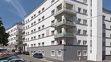
The Josef-Wiedenhofer-Hof is a community building built in 1924/25 according to plans by the well-known architect and designer Josef Frank . The representative facade of the trapezoidal building block with zungenförmigem Hoftrakt is on the Congress Square directed, while the main entrance is closest to the access to public transport on Hernalser station square is due to those in the Zeillergasse (Nos. 7-11). Decorative and structural elements were largely dispensed with, apart from the light sill cornices and window frames, which contrasted with the original orange-red color scheme of the building. Because of this ensemble-defining color and the flat roof, which was still unusual for that time, the Wiedenhoferhof was also popularly known as the “Paprikakistl”. The increase in storeys in 1953, during which the flat roof was also replaced by a gable roof, and the plinth renovation in 2009-2013 (including loft extension), which replaced the characteristic red-orange with white, resulted in radical changes in terms of proportions and appearance.
Station building of the suburb line
The Vienna Hernals train station, which opened in 1898, is the work of the famous turn-of-the-century architect Otto Wagner . The station is located high above the Hernalser Hauptstraße , which is crossed diagonally by the suburb line over a bridge . Due to the inclined position of the building due to the rail routing, it does not have a front facing directly onto the main street, which is why the two entrance facades (towards Frauenfeld and Neuottakring) are almost equally designed. The asymmetrical building, with its monumental corner (crowned corner protrusion over portal, brick viaduct arch , platform roof visible from the street), has a significant impact on the station (front) square , on which it, together with the Holyhof by Rudolf Perco (already in the Hernals cadastral area) and the Neo-Biedermeier-late Secessionist corner house at Hernalser Hauptstrasse No. 180, which is oriented towards the square with a sloping facade and forms a relatively monumental ensemble.
Personalities
- Conrad Haas (1509–1576), military technician and rocket pioneer
- Bartholomäus Pethan (1573), Italian master stonemason
- Wilhelm von Haidinger (1795–1871), geologist and mineralogist
- Franz Glaser Sr. (1822 in Laubendorf – 1885), master builder and mayor of Dornbach
- Franz Glaser jun. (1852–1934), architect
- Heinrich Glaser (1855–1928), architect, master builder and councilor
- Julius Klinger (1876–1942), painter and writer
- Anton Heiller (1923–1979), musician and composer
- Hugo Strache (1865–1927), chemist
literature
- Helfried Seemann: Dornbach - Neuwaldegg: 1880–1960 . Album Verlag, Vienna 2000, ISBN 3-85164-086-1
- Rudolf Spitzer: Hernals: between belt and Hameau . Mohl, Vienna 1991, ISBN 3-900272-39-5
Web links
- Dornbacher Geschichts- und Kulturverein Association for the preservation of the townscape of Dornbach and Neuwaldegg
Individual evidence
- ^ Opening of the horse railroad Local-Anzeiger der Presse, October 5, 1865. In: AW: Pferdeeisenbahnen. harry, July 24, 2008, 11:44 am, http://www.sagen.at/forum/ , accessed February 6, 2017 (digitized from: ANNO ).
Coordinates: 48 ° 14 ' N , 16 ° 18' E


