Höcherberg
| Höcherberg | ||
|---|---|---|
|
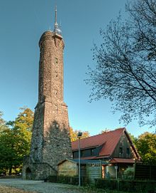
View of the Höcherberg from the south |
||
| height | 518 m above sea level NHN | |
| location | Saarland , Germany | |
| Mountains | North Palatinate Uplands | |
| Coordinates | 49 ° 23 '51 " N , 7 ° 15' 57" E | |
|
|
||
| particularities | - Höcherberg tower ( AT ) - transmitter masts |
|
The Höcherberg is located in the east of the Saarland and is part of the North Palatinate Uplands . It towers above with a height of 518 m. NHN the city of Bexbach, which is about 5 km away, by 250 meters.
location
The Höcherberg is 5 km north of Bexbach and 15 km north of the city of Homburg . The mountain range drops sharply to the south, to the north it exceeds the surrounding mountains by about 150 meters.
With the Höcher mine dump shaft III as a landmark visible from afar, the Höcherberg can also be seen from a great distance. This represents the highest coal mine in Germany with a summit height of 494.3 m above sea level. NHN .
The Glan rises in the Höchen district of Bexbach, 1 km from the summit . With Höchen, Frankenholz and Oberbexbach, the ridge covers the north of the city of Bexbach as well as the districts of Waldziegelhütte and Dunzweiler of the Palatinate community of Waldmohr , the Neunkirchen district of Münchwies , of the city of Ottweiler the districts of Lautenbach and Remmesfürth and the Homburg districts of Altbreitenfelderhof and Websweiler .
history
Although relics of Roman times were found on the Höcherberg, such as the remains of a Roman road (connection Tholey - Schwarzenacker ) and the remains of a Roman stone of the four gods, the region of the mountain was settled relatively late. The town of Höchen was mentioned in 1263, the monastery courtyards in Frankenholz and Münchwies fell fallow in the Thirty Years War , and these settlements were not re-established until the late 17th century. In 1999 the forest north of the summit was badly hit by Hurricane Lothar .
Development of the mountain
In 1893 a wooden tower was built on the mountain , which was used by the Berlin topographic office for land surveying . In 1913, on the initiative of the teacher Georg Hengstenberg, who was chairman of the Palatinate Forest Association in Höchen, the construction of a 26-meter-high observation tower began. The costs, which amounted to 20,000 marks by the time it was completed, were paid for by a tower building association. In 1929 the Palatinate Forest Association built the Höcherberghaus hiking home next to the tower . There is also an elevated water tank and several transmission masts on the mountain . The amateur radio relay DB0YK, which is equipped for emergency radio, is located on the tower . From 1903 to 1905 the Nordfeldbahn, exclusively used for freight traffic, ran from the Jägersburg station on the Glantalbahn to the Nordfeld pit , which was located on the northern slope of the mountain.
Distant view
When the weather is clear, the view extends from the Höcherberg to the Erbeskopf in the Hunsrück , to the Donnersberg and the Palatinate Forest . The Vosges (99.6 km to the Donon) and even the Hornisgrinde (112 km) in the Black Forest can be seen. In addition, the Saar polygon (36 km) on the Ensdorf heap can be recognized as an interesting landmark.
Hiking trails
The Saarland circular hiking trail leads directly past the tower and hiking home. Also leading Höcherbergweg the Saar forest club appropriately enough to the mountain. The local association Höchen of the Palatinate Forest Association has marked 5 circular hiking trails around the mountain, the hiking times of which range from 45 minutes to 4.5 hours. The Bexbacher Rundwanderweg, built in March 2007, also leads past the mountain.
Watershed
The watershed between Nahe / Glan and Blies runs over the Höcherberg .
Höcherberg community
From 1937 to 1947 there was an independent community with the name Höcherberg .
swell
- C. Missy, R. Ohm: Höchen once and now , 1987, Verlag Hügel GmbH, Bexbach
- Hiking map of the Palatinate Forest Association, local group Höchen
- Hiking map of the Saarwaldverein


