
Höchstädt in the Fichtel Mountains
| coat of arms | Germany map | |
|---|---|---|

|
Coordinates: 50 ° 6 ' N , 12 ° 5' E |
|
| Basic data | ||
| State : | Bavaria | |
| Administrative region : | Upper Franconia | |
| County : | Wunsiedel in the Fichtel Mountains | |
| Management Community : | Thiersheim | |
| Height : | 565 m above sea level NHN | |
| Area : | 14.95 km 2 | |
| Residents: | 1063 (Dec. 31, 2019) | |
| Population density : | 71 inhabitants per km 2 | |
| Postal code : | 95186 | |
| Area code : | 09235 | |
| License plate : | WUN, MAK, REH , SEL | |
| Community key : | 09 4 79 126 | |
| Community structure: | 6 districts | |
| Address of the municipal administration: |
V.-Waldenfels-Platz 2 95186 Höchstädt i.Fichtelgebirge |
|
| Website : | ||
| Mayor : | Gerald Bauer ( CSU ) | |
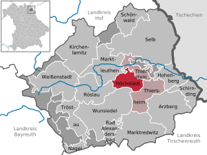
| Location of the municipality of Höchstädt i.Fichtelgebirge in the district of Wunsiedel in the Fichtelgebirge | ||
  |
||

Höchstädt im Fichtelgebirge (officially Höchstädt i.Fichtelgebirge ) is a municipality in the Upper Franconian district of Wunsiedel in the Fichtelgebirge . The place of the same name is both the capital and the seat of the municipal administration.
Community structure
There are six districts:
|
history
Until the church is planted and merged
The settlement was first mentioned in documents in 1298. Höchstädt was one of the first acquisitions by the burgraves of Nuremberg in what was later to become the Sechsämterland , which were combined in the Hohenberg / Wunsiedel office . The previous owners were probably the Lords of Hohenberg. There were two manors in the village, both of which were fiefdoms from the Burgraves of Nuremberg and the later Margraves of Brandenburg : Oberhöchstädt and Unterhöchstädt. From 1398 to 1559 the manor Oberhöchstädt was in the hands of the Egerland imperial ministerial family Rorer . This was followed by the gentlemen von Witzleben from Thuringia. During the Thirty Years War , the Oberhöchstädt manor was largely destroyed and its owners no longer fulfilled their fiefdom obligations. Therefore it was confiscated as forfeited by Margrave Christian zu Brandenburg-Kulmbach and sold to the Wunsiedler Hospital Foundation in 1644 for 6200 guilders . This at least acquired the manor buildings back from the Rohrer family in 1982, and today they are again in the hands of the descendants of the late medieval owners. In addition to an art gallery, they also operate the Höchstädt Castle Museum there. The manor Unterhöchstädt was owned by the von Uttenhofen family around 1370, then passed to the lower nobility Santner family and was acquired in 1413 by the von Rabenstein gentlemen, who originally came from Rabeneck Castle near Waischenfeld in Franconian Switzerland . These were owned by the manor until 1534, when they were followed by the Lords of Haidenaab. In the Thirty Years War Unterhöchstädt was badly affected; In 1668 the manor came to the Lords of Waldenfels , who lived in the castle until 1847. Soon afterwards, Unterhöchstädt Castle, which had been damaged by fire, became the property of the municipality. After many years of use as a school building, it is now used as the seat of the municipal administration and for residential purposes.
In 1791 Höchstädt came to Prussia with the Margraviate Bayreuth . In 1806 it was occupied by French troops and in 1810 it became part of Bavaria. In 1818 the communities of Unter- and Oberhöchstädt were established, and in 1821 they were merged to form the municipality of Höchstädt.
Name change
In 1995 the place name was changed from Höchstädt near Thiersheim to Höchstädt im Fichtelgebirge.
Incorporations
In 1923 Tännig was incorporated. On January 1, 1978, part of the dissolved municipality of Neudes with then about 100 inhabitants was incorporated.
Population development
Between 1988 and 2018, the population fell or stagnated from 1,092 to 1,080 by 12 inhabitants or 1.1%.
politics
The community is a member of the Thiersheim administrative community .
mayor
The first mayor is Gerald Bauer ( CSU ). In a runoff election on March 30, 2014, he was elected with 55.5% to succeed Rudolf Reichel ( CSU ).
Municipal council
| CSU | SPD | Non-party list / free electoral community | total | |
| 2014 | 5 | 4th | 3 | 12 seats |
| 2008 | 5 | 4th | 3 | 12 seats |
| 2002 | 6th | 4th | 2 | 12 seats |
coat of arms
|
|
Blazon : "Under a shield head quartered by silver and black, quartered by red and black, topped with a silver bar."
The coat of arms is composed of the coat of arms of the Rohrer family (lower part) and the von Hohenzollern family (black and silver crossing). The Rohrer family is represented in the coat of arms of Oberhöchstädt Castle because of its long tradition. The von Hohenzollern family ruled over the Sechsämterland in which Höchstädt is located for 500 years . To commemorate this connection, the black and silver crossing was added to the coat of arms. |
Attractions
- Evangelical Peter and Paul Church
- town hall
- Castle Museum
- Töpferhof, an adventure pottery
- Stoakirch'n, a rock formation on the castle hill
- Hofmühle
- Adelsmühle
- Gasthof Reichsadler
- Gasthof zur Hölle (unchanged since 1902)
- Schlosshügel mountain restaurant (since 1910)
- Gasthof Einhorn
Soil monuments
literature
- Johann Kaspar Bundschuh : Höchstädt . In: Geographical Statistical-Topographical Lexicon of Franconia . tape 2 : El-H . Verlag der Stettinische Buchhandlung, Ulm 1800, DNB 790364298 , OCLC 833753081 , Sp. 696 ( digitized version ).
- Johann Kaspar Bundschuh : Oberhöchstett . In: Geographical Statistical-Topographical Lexicon of Franconia . tape 4 : Ni-R . Verlag der Stettinische Buchhandlung, Ulm 1801, DNB 790364301 , OCLC 833753101 , Sp. 177 ( digitized version ).
- Johann Kaspar Bundschuh : Unterhöchstätt . In: Geographical Statistical-Topographical Lexicon of Franconia . tape 5 : S-U . Verlag der Stettinische Buchhandlung, Ulm 1802, DNB 790364328 , OCLC 833753112 , Sp. 629 ( digitized version ).
- Chronicle Höchstädt in the Fichtelgebirge - 1298–1998 - 700 years. Höchstädt 1998.
- Dietmar Herrmann: The town hall fountain in Höchstädt. In: Der Siebenstern , Heft 3-2015, p. 18
- Dietmar Herrmann, Helmut Süssmann: Fichtelgebirge, Bavarian Vogtland, Steinwald, Bayreuther Land: Lexicon . Ackermannverlag, Hof 2000, ISBN 3-929364-18-2 .
- Bernhard Hermann Röttger : District of Wunsiedel and urban district of Marktredwitz. Die Kunstdenkmäler von Bayern , VIII. Administrative Region Upper Franconia, Volume 1. Munich 1954. ISBN 3-486-41941-2 , pp. 123-129.
- Martin Schikora: 100 years of ATV Höchstädt - from a political gymnastics club to a family sports club with culture . Höchstädt 2011.
- Harald Stark : The Oberhöchstädt manor. In: Archive for the history of Upper Franconia . Volume 78. Bayreuth 1998. pp. 41-112.
- Pleikard Joseph Stumpf : Höchstädt . In: Bavaria: a geographical-statistical-historical handbook of the kingdom; for the Bavarian people . Second part. Munich 1853, p. 634 ( digitized version ).
Web links
Individual evidence
- ↑ "Data 2" sheet, Statistical Report A1200C 202041 Population of the municipalities, districts and administrative districts 1st quarter 2020 (population based on the 2011 census) ( help ).
- ↑ http://www.bayerische-landesbibliothek-online.de/orte/ortssuche_action.html ? Anzeige=voll&modus=automat&tempus=+20111206/170446&attr=OBJ&val= 1300
- ^ Federal Statistical Office (ed.): Historical municipality directory for the Federal Republic of Germany. Name, border and key number changes in municipalities, counties and administrative districts from May 27, 1970 to December 31, 1982 . W. Kohlhammer GmbH, Stuttgart / Mainz 1983, ISBN 3-17-003263-1 , p. 700 .
- ↑ Greetings. Höchstädt municipality in the Fichtelgebirge, accessed on August 19, 2020 .
- ↑ Entry on the coat of arms of Höchstädt in the Fichtelgebirge in the database of the House of Bavarian History

Arzberg | Bad Alexandersbad | Höchstädt in the Fichtel Mountains | Hohenberg an der Eger | Kirchenlamitz | Market people | Marktredwitz | Nail | Röslau | Schirnding | Schönwald | Same | Thiersheim | Thierstein | Tröstau | Weißenstadt | Wunsiedel
Unregulated areas in the district of Wunsiedel in the Fichtelgebirge
Kaiserhammer Forst-Ost |
Martinlamitzer Forst-Süd |
Meierhöfer Page |
Neubauer Forst-Süd |
Tröstauer Forst-Ost |
Tröstauer Forst-West |
Vordorf Forest |
Weißenstadter Forst-Nord |
Weißenstadter Forst-Süd