Hohenwart
| coat of arms | Germany map | |
|---|---|---|

|
Coordinates: 48 ° 36 ' N , 11 ° 23' E |
|
| Basic data | ||
| State : | Bavaria | |
| Administrative region : | Upper Bavaria | |
| County : | Pfaffenhofen on the Ilm | |
| Height : | 395 m above sea level NHN | |
| Area : | 52.23 km 2 | |
| Residents: | 4771 (Dec. 31, 2019) | |
| Population density : | 91 inhabitants per km 2 | |
| Postal code : | 86558 | |
| Area code : | 08443 | |
| License plate : | PAF | |
| Community key : | 09 1 86 128 | |
| LOCODE : | DE OWR | |
| Market structure: | 23 districts | |
Market administration address : |
Marktplatz 1 86558 Hohenwart |
|
| Website : | ||
| Mayor : | Jürgen Haindl (Free Voters) | |
| Location of the Hohenwart market in the Pfaffenhofen an der Ilm district | ||
Hohenwart is a market in the Upper Bavarian district of Pfaffenhofen an der Ilm .
geography
The community is located in the Ingolstadt planning region , just under 20 km south-southwest of Ingolstadt .
There are 23 districts :
|
|
|
The districts are Deimhausen, Freinhausen, Haidforst, Hohenwart, Klosterberg, Koppenbach, Lindach, Seibersdorf, Weichenried, Thierham and Schlott.
history
Until the church is planted
The origin of Hohenwart was a former castle of the Rapotonen . The last of this family founded a women's monastery in the fortification in 1074 . Hohenwart was granted market rights in 1356 and was moved from Klosterberg to the banks of the Paar at the end of the 14th century . The Hohenwart market belonged to the Munich Rent Office and the Pfaffenhofen Regional Court of the Electorate of Bavaria . Hohenwart had a market court with its own magistrate rights. In the course of the administrative reforms in Bavaria , today's municipality was created with the municipal edict of 1818 .
19th and 20th centuries
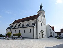
The hohenwart abbey was 1803 secularized and the monastery church to the parish church of St. George rededicated. The monastery buildings have been owned by the Regens-Wagner Foundation in Dillingen since 1878 and house facilities for the hearing impaired.
During the district reform , Hohenwart was assigned to the Pfaffenhofen an der Ilm district on July 1, 1972 by the Schrobenhausen district.
Incorporations
On October 1, 1971, the previously independent community of Deimhausen was incorporated. On January 1, 1972, Seibersdorf and Weichenried were added. Finally, Freinhausen, Klosterberg and Koppenbach followed on January 1, 1978.
Population development
Between 1988 and 2018 the market grew from 3,484 to 4,699 inhabitants or by 34.9%.
- 1970: 3336 inhabitants
- 1987: 3407 inhabitants
- 1991: 3580 inhabitants
- 1995: 3899 inhabitants
- 2000: 4112 inhabitants
- 2005: 4,327 inhabitants
- 2010: 4523 inhabitants
- 2015: 4569 inhabitants
politics
mayor
The first mayor is Jürgen Haindl (Free Voters), his deputy is Thomas Rolnik.
Municipal council
The 2020 local elections resulted in the following distribution of seats:
- Christian Social Union: 8 seats
- Free voters Hohenwart (FW): 8 seats
coat of arms
|
Blazon : "In gold, St. George in blue armor and a silver skirt on a red-bridled black steed that bursts to the left, piercing the green lindworm crouching on the green ground with the red lance."
History of the coat of arms: St. George was the patron saint of the former Benedictine monastery on the Klosterberg and was therefore also the patron saint of the Hohenwart market, which had developed as a settlement around the monastery. The market already had its own seal in the middle of the 14th century, which was first mentioned in a document in 1349 and has been handed down in prints since 1374. Until 1606, the market seal showed St. George standing on a pedestal, nimbly, in chain mail with a short tunic, a lance in his right hand, a cross shield on his left arm, but without a dragon. Since the old seal had been worn out through centuries of use and was no longer legible, the mayor and council asked for their badge to be renewed and improved. A draft for the new coat of arms with the local patron was submitted. Duke Maximilian I gave the market the improved coat of arms, on which St. George is shown riding on horseback above the green Lindwurm in blue armor and red lance. The coat of arms was also found in this form in the following years in seals and in heraldic literature. |
|
Architectural monuments
- Ensemble Kapellenstrasse (Hohenwart)
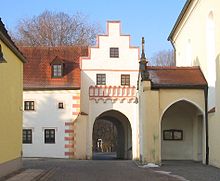
- Ensemble Marktplatz / Unterer Markt (Hohenwart)
- Parish Church of St. George
- Church of St. Johannes Baptist in the hamlet of Englmannszell
Soil monuments
Economy and Infrastructure
Economy including agriculture and forestry
In 1998, according to official statistics in the manufacturing industry 116 and in the trade and transport sector, there were no employees at work subject to social security contributions. There were 693 employees at the place of residence subject to social security contributions. There were none in manufacturing and two in construction. In addition, in 1999 there were 55 farms with an agriculturally used area of 640 hectares (ha), of which 192 hectares were arable land and 445 hectares were permanent green areas.
Kindergartens
- Kindergarten S.Wolfoldus on Schulstrasse, Hohenwart
- Kindergarten St.Johannes, Weichenried
- Richildis day nursery on Schulstrasse, Hohenwart
- School preparatory facility for hearing-impaired children (Regens Wagner)
schools
- Elementary and middle school Hohenwart
- Regens-Wagner-Schule Hohenwart - private support center for the hearing impaired
Web links
Individual evidence
- ↑ "Data 2" sheet, Statistical Report A1200C 202041 Population of the municipalities, districts and administrative districts 1st quarter 2020 (population based on the 2011 census) ( help ).
- ^ Hohenwart community in the local database of the Bavarian State Library Online . Bayerische Staatsbibliothek, accessed on September 12, 2019.
- ^ Wilhelm Volkert (ed.): Handbook of Bavarian offices, communities and courts 1799–1980 . CH Beck, Munich 1983, ISBN 3-406-09669-7 , p. 567 .
- ^ Federal Statistical Office (ed.): Historical municipality directory for the Federal Republic of Germany. Name, border and key number changes in municipalities, counties and administrative districts from May 27, 1970 to December 31, 1982 . W. Kohlhammer, Stuttgart / Mainz 1983, ISBN 3-17-003263-1 , p. 586 .
- ^ Local councils. Hohenwart community, accessed on August 22, 2020 .
- ^ Local councils
- ^ Entry on Hohenwart's coat of arms in the database of the House of Bavarian History


