Icknield Way
The Icknield Way is a historic footpath in southern England. It is located in the year-round dry area above the springs on the chalk - Escarpment of the Berkshire Downs and Chiltern Hills .
history
The Icknield Way is believed to be one of the oldest long-haul routes in Great Britain and was used before the Romans occupied the country, although there is little scientific evidence of this.
The name is of Celtic-British origin and can be traced back to the Iceni tribe who used this route for trade from their base in East Anglia with other parts of the country. The path could also be of even older prehistoric origin. Unlike a Roman road, it is not a single, systematic path, but a group of historically created trails from Berkshire to Oxfordshire , crossing the Thames at Cholsey near Wallingford and dating from the Iron Age (i.e. long before the Roman Invasion 43 AD) were used until Anglo-Saxon times.
route

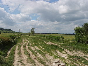
In many places, the Icknield Way consists or consisted of several parallel stretches, particularly along the line of the Chiltern escarpment , probably because of seasonal use and possibly because of the amount of traffic, especially the herds of cattle.
To the west it lies beneath the steep slopes of the Wessex Downs . Near Wantage , the route along the Ridge of the Downs is known as The Ridgeway , and the name Icknield Way is a parallel route in the lowlands above the water sources on the northern edge of the Chalk. Between Lewknor and Ivinghoe Beacon there are two parallel routes known as the Lower Icknield Way and Upper Icknield Way . In Cambridgeshire, Street Way ( Ashwell Street ), Ditch Way and other routes are used as variants, for use in summer or winter.
The Icknield Way forms part of the border between Hertfordshire and Cambridgeshire, and in earlier times Royston was cut in two by this border. In Royston, Icknield Way crosses Ermine Street .
Icknield Way Path
There is now a long distance walking trail called the Icknield Way Path. It runs from Ivinghoe Beacon in Buckinghamshire to Knettishall Heath in Suffolk , where the Peddars Way begins. The trail was designed and maintained in 1992 by the Icknield Way Association with support from the Ramblers Association . Planning, the road along the entire route of the historic footpaths from the south coast up to The Wash the National Trail to confer status, have not been successful so far.
Because parts of the Ridgeway National Trail and the Icknield Way Path are only usable for pedestrians, there is also the Icknield Way Path Riders Route and the Icknield Way Trail , which was created for riders and mountain bikers. The route runs from Bledlow to Roudham Heath , where it merges into the Peddars Way Horseriders Route .
Modern streets

Many modern roads follow the Icknield Way, for example the A505 from Baldock to Royston and the B489 from Aston Clinton to Dunstable . In some places, especially from Luton in Bedfordshire to Ickleford (so named because the Icknield Way crosses a stream there) and near Hitchin in Hertfordshire , several back roads follow the route. In other places you can hardly see the route, with the exception of graves and burial mounds, and trodden paths and ravines that have resulted from frequent use. The Icknield Way can be described as a belt studded with archaeological sites at irregular intervals.
Earliest written mention
The earliest written mention of the Icknield Way is in Anglo-Saxon documents from 903. The oldest surviving copies were made in the 12th and 13th centuries, and these use the spellings Ic (c) enhilde weg, Icenhylte, Icenilde weg, Ycenilde gone and Icenhilde gone . The deeds relate to places at Wanborough , Hardwell in Uffington , Harwell , Blewbury and Risborough , over a distance of 65 km (40 miles) from Wiltshire to Buckinghamshire .
Individual evidence
- ^ A b S. Harrison, "The Icknield Way: some queries", The Archaeological Journal , 160, 1-22, 2003.
- ↑ K. Matthews, Circular Walk (Wilbury Hill, Ickleford, Cadwell, Wilbury Hill) ( Memento of the original from May 13, 2008 in the Internet Archive ) Info: The archive link was automatically inserted and not yet checked. Please check the original and archive link according to the instructions and then remove this notice. (PDF; 325 kB) .
- ^ R. Bradley, Solent Thames Research Assessment - the Neolithic and Early Bronze Age (PDF; 142 kB), 2008.
- ^ Rhiannon, The Icknield Way: Miscellaneous , 2008.
- ↑ Icknield Way Morris Men, Prehistory - Ancient Paths ( Memento of the original from December 27, 2009 in the Internet Archive ) Info: The archive link was automatically inserted and not yet checked. Please check the original and archive link according to the instructions and then remove this notice. .
- ^ E. Thomas, The Icknield Way , Constable, 1916.
- ^ Icknield Way Path
- ↑ Walking pages ( Memento of the original from April 13, 2010 in the Internet Archive ) Info: The archive link was inserted automatically and has not yet been checked. Please check the original and archive link according to the instructions and then remove this notice.
- ^ Icknield Way Path (a series of three leaflets for riders), Countryside Commission, 1992.
- ^ North Chilterns Trust, The Icknield Way Trail: Bedfordshire and West Hertfordshire , c. 2007.
- ^ Long Distance Walkers Association, Icknield Way Trail .
- ^ British Horse Society, Icknield Way, Riders' Way and Peddars Way (National Trail) .
- ^ Buckinghamshire County Council, The Icknield Way ( Memento of the original from June 7, 2011 in the Internet Archive ) Info: The archive link was automatically inserted and has not yet been checked. Please check the original and archive link according to the instructions and then remove this notice. (PDF; 657 kB).
Coordinates: 51 ° 50 ′ 30.6 " N , 0 ° 36 ′ 29.2" W.
